Just a quick post to prove I'm still alive and kicking. Well, alive, anyway.
I think this was June 20, 1972, or thereabouts. I used a Kodak Instamatic back then, and Kodachrome transparency film.
It's Concorde 002, I think. First visit to Australia. Sydney Airport International Terminal, next to a Pan Am 707 and framed by a Qantas 707 in "V-Jet" colours.
Shops and services
Jargon-free PC Help
Quality tech products
Bike gear
Books, games, DVDs
Photography tips and tricks
My Most Popular Blogs
Photography tips and tricks
Alfa Romeo Tipo 116
My Opinion
Business, Opinion and Nonsense
Airliners
Business blogging
My Opinion
More Business blogging
Myths and legends
Photography
Photography tips and tricks
History
Sydney history
Bikes and bike racing
Bike racing
Bike racing for beginners
Bike racing 101
Doper's guide to bike racing
Cars - and Alfa Romeos
Alfa Romeo Tipo 116
GTVeloce Style
Showing posts with label Sydney. Show all posts
Friday, March 8, 2019
Monday, March 20, 2017
A brief look at Melbourne's airports (for comparison?)
Melbourne. It's a city somewhere south-ish of Sydney. And it bears comparison with Sydney, in an instructive sense, because it's like a sister-city, just smaller and somewhat quainter. I like it.
Apparently they - both the Victorian State and some private interests - are thinking ahead and looking at another major airport option for Melbourne. This would be to the south and east. Now this could be a realistic and earnest attempt to reserve some appropriate land and prepare for the future, or equally it could be a political effort driven by other agendas - like making a buck out of hemmed-in Essendon by closing it down and selling off the land. (Mind you it's already privately leased and partly developed.)
Or it could be a bit of both.
Melbourne is blessed with airports, to be honest. Sydney has managed to close off many of its options, like Schofields and Hoxton Park, and has tended to build up Mascot and Bankstown instead. (The RAAF has Richmond, of course.)
(Sydney once had a plethora of post-war, sizeable airstrips scattered all around the Sydney Basin. Check out the list. Only a choice few remain in use.)
I've flown in and out of Melbourne's Tullamarine a few times, and have seen it grow from almost nothing to quite something. But it's still nothing like Sydney's Mascot. Well, it's smaller and more pleasant with a lot less history. For history try Essendon instead.
There's room for growth at Tullamrine and also a case to close - or keep - Essendon, too. Even Tullamarine is getting surrounded. It's what happens - successful airports attract people and businesses. They can be closed and redeveloped but you lose the transport utility, which gets pushed further out. Currently Essendon is a mixed-use zone which retains that utility close to the CBD.
Speaking of 'further out', Sydney struggled to get Badgery's up and running - if indeed it is running. Ambling, perhaps. I remember grabbing a hard-copy of the MANS report back in the 1970s, when it looked like Peat's Ridge would get the nod. And the to-ing and fro-ing that has happened ever since was fascinating to observe. Badgery's is a better site in many ways, a lot flatter and whilst slap-bang in the west of Sydney where lots of people live, still rural enough to put a buffer around the noise. It balances Mascot's extreme easterly location, certainly. Some train links would help, but buses will do for starters. And it will probably spend a few decades handling freight before pax, anyway.
It's far more complicated than that, of course.
Sydney also has Bankstown, just as Melbourne has Moorabbin. Both have a lot of history, although Bankstown probably wins on that score, in case you are keeping score. Both are hemmed in by housing and light industry plus some open space.
Bankstown is almost Sydney's Essendon, but more closely parallels Moorabbin as a GA facility. The scheduled flights that have operated out of Bankstown always fell short by some measure or other and were largely abandoned, despite many efforts over the decades. WWII saw a lot of use fro Bankstown, including aircraft assembly or manufacture. Post-war has seen a gradual loss of such activity but considerable GA traffic. Being too close to Mascot and surrounded by too many vocal voters in their ever-so-local houses makes it an unlikely prospect for growth. If anything it has shrunk.
So back to Melbourne. They also have Avalon, a domestic and sometime international airport with plenty of land for expansion and existing heavy-aircraft maintenance facilities situated close to Geelong.
Plus a host of GA fields dotted around, like Moorabbin but also Lilydale, Bacchus Marsh and Melton.
Do they really need another airport? Traffic-wise, probably not, or at least not yet. For convenience, maybe. For growth, possibly. The south-east makes some sense as the somewhat inconvenient Avalon is to the south and west and Tullamarine is to the north. But it's hardly a pressing need. It's more of a strategic planning initiative, to get the idea out there and to reserve the land now. Which is what Badgery's was, too. Reserve the land ahead of time so that the option is kept open. (Although that was more luck than good planning.)
Conclusions? It's probably too early to say with any certainty, but it looks like a cross between good planning and a bit of 'I wish'. It's certainly a better situation than that of (arguably) under-resourced and ill-planned Sydney. Badgery's may change that, of course.
More reading on Melbourne's "3rd" airport. And a possibly serious proposal, or some self-promotion.
An historical note on aviation at Fishermen's Bend and Monomeith Park.
And a mixture of historical, military and sometime civilian operations from Laverton, Point Cook and Werribee which we'll list under RAAF Williams.
Checkout my list of Sydney and surrounding airstrips and airports.
Apparently they - both the Victorian State and some private interests - are thinking ahead and looking at another major airport option for Melbourne. This would be to the south and east. Now this could be a realistic and earnest attempt to reserve some appropriate land and prepare for the future, or equally it could be a political effort driven by other agendas - like making a buck out of hemmed-in Essendon by closing it down and selling off the land. (Mind you it's already privately leased and partly developed.)
Or it could be a bit of both.
Melbourne is blessed with airports, to be honest. Sydney has managed to close off many of its options, like Schofields and Hoxton Park, and has tended to build up Mascot and Bankstown instead. (The RAAF has Richmond, of course.)
(Sydney once had a plethora of post-war, sizeable airstrips scattered all around the Sydney Basin. Check out the list. Only a choice few remain in use.)
I've flown in and out of Melbourne's Tullamarine a few times, and have seen it grow from almost nothing to quite something. But it's still nothing like Sydney's Mascot. Well, it's smaller and more pleasant with a lot less history. For history try Essendon instead.
There's room for growth at Tullamrine and also a case to close - or keep - Essendon, too. Even Tullamarine is getting surrounded. It's what happens - successful airports attract people and businesses. They can be closed and redeveloped but you lose the transport utility, which gets pushed further out. Currently Essendon is a mixed-use zone which retains that utility close to the CBD.
Speaking of 'further out', Sydney struggled to get Badgery's up and running - if indeed it is running. Ambling, perhaps. I remember grabbing a hard-copy of the MANS report back in the 1970s, when it looked like Peat's Ridge would get the nod. And the to-ing and fro-ing that has happened ever since was fascinating to observe. Badgery's is a better site in many ways, a lot flatter and whilst slap-bang in the west of Sydney where lots of people live, still rural enough to put a buffer around the noise. It balances Mascot's extreme easterly location, certainly. Some train links would help, but buses will do for starters. And it will probably spend a few decades handling freight before pax, anyway.
It's far more complicated than that, of course.
Sydney also has Bankstown, just as Melbourne has Moorabbin. Both have a lot of history, although Bankstown probably wins on that score, in case you are keeping score. Both are hemmed in by housing and light industry plus some open space.
Bankstown is almost Sydney's Essendon, but more closely parallels Moorabbin as a GA facility. The scheduled flights that have operated out of Bankstown always fell short by some measure or other and were largely abandoned, despite many efforts over the decades. WWII saw a lot of use fro Bankstown, including aircraft assembly or manufacture. Post-war has seen a gradual loss of such activity but considerable GA traffic. Being too close to Mascot and surrounded by too many vocal voters in their ever-so-local houses makes it an unlikely prospect for growth. If anything it has shrunk.
So back to Melbourne. They also have Avalon, a domestic and sometime international airport with plenty of land for expansion and existing heavy-aircraft maintenance facilities situated close to Geelong.
Plus a host of GA fields dotted around, like Moorabbin but also Lilydale, Bacchus Marsh and Melton.
Do they really need another airport? Traffic-wise, probably not, or at least not yet. For convenience, maybe. For growth, possibly. The south-east makes some sense as the somewhat inconvenient Avalon is to the south and west and Tullamarine is to the north. But it's hardly a pressing need. It's more of a strategic planning initiative, to get the idea out there and to reserve the land now. Which is what Badgery's was, too. Reserve the land ahead of time so that the option is kept open. (Although that was more luck than good planning.)
Conclusions? It's probably too early to say with any certainty, but it looks like a cross between good planning and a bit of 'I wish'. It's certainly a better situation than that of (arguably) under-resourced and ill-planned Sydney. Badgery's may change that, of course.
More reading on Melbourne's "3rd" airport. And a possibly serious proposal, or some self-promotion.
An historical note on aviation at Fishermen's Bend and Monomeith Park.
And a mixture of historical, military and sometime civilian operations from Laverton, Point Cook and Werribee which we'll list under RAAF Williams.
Checkout my list of Sydney and surrounding airstrips and airports.
Tuesday, October 25, 2016
Sydney's water supply over time
A big topic with much to cover. By necessity - at this stage - I'll simply scratch the surface.
Early Sydney's water supply was largely dependent upon the Tank Stream, so called for the grooves or "tanks" cut into its bed (reputedly an Indian sub-continental loan word as well as a fortuitously imported water storage technique). The stream is now largely buried under Sydney's concreted CBD.
Busby's bore, more or less what we would now call a tunnel, was located in the western corner of today's Centennial Park and ran to Hyde Park. See also the Lachlan Swamps.
Later water supplies were drawn from Botany, near Sydney Airport. Remains of a steam-driven pumping station can still be seen near the eastern boundary of the airport. See also Ascot Racecourse.
With Sydney's growth over time, water was drawn from further afield and major, increasingly elaborate constructions, including reservoirs, tunnels and channels were undertaken. Much of this remains in place, either in use as intended, re-purposed or as a heritage site.
The Prospect reservoir is one such early attempt to capture a larger area of rainfall and move it eastwards.
Another significant part of Sydney's water supply history is the Nepean Dam, the last and the smallest of the four dams finished early in the 20th Century to collect water from the rising lands of the Illawarra Plateau, the major, southern source of the oddly north-westerly flowing Nepean River (which later makes a curving right turn to flow east - as the Hawkesbury River - into the Pacific Ocean north of Sydney).
See also the Cataract, Avon and Cordeaux dams. These and the Nepean Dam were part of the Upper Nepean Scheme, which fed into an earlier set of weirs and other infrastructure, including the 1880's vintage Potts Hill and Prospect reservoirs. A good explanation of how the system expanded and operated may be found here.
The Nepean Dam may possibly also have been a WWII-era emergency alighting area for seaplanes. Checkout my list of Sydney and surrounding airstrips and airports.
Another dam was constructed south of Sydney after the Nepean system, at Woronora, largely serving southern Sydney.
Also worth looking into is Parramatta's water supply.
The far larger Warragamba dam was built largely post WWII on a western tributary of the Nepean River and largely replaces or vastly enhances this earlier system, although all remain important, and in operation.
More can be found at the Dictionary of Sydney.
Early Sydney's water supply was largely dependent upon the Tank Stream, so called for the grooves or "tanks" cut into its bed (reputedly an Indian sub-continental loan word as well as a fortuitously imported water storage technique). The stream is now largely buried under Sydney's concreted CBD.
Busby's bore, more or less what we would now call a tunnel, was located in the western corner of today's Centennial Park and ran to Hyde Park. See also the Lachlan Swamps.
Later water supplies were drawn from Botany, near Sydney Airport. Remains of a steam-driven pumping station can still be seen near the eastern boundary of the airport. See also Ascot Racecourse.
With Sydney's growth over time, water was drawn from further afield and major, increasingly elaborate constructions, including reservoirs, tunnels and channels were undertaken. Much of this remains in place, either in use as intended, re-purposed or as a heritage site.
The Prospect reservoir is one such early attempt to capture a larger area of rainfall and move it eastwards.
Another significant part of Sydney's water supply history is the Nepean Dam, the last and the smallest of the four dams finished early in the 20th Century to collect water from the rising lands of the Illawarra Plateau, the major, southern source of the oddly north-westerly flowing Nepean River (which later makes a curving right turn to flow east - as the Hawkesbury River - into the Pacific Ocean north of Sydney).
See also the Cataract, Avon and Cordeaux dams. These and the Nepean Dam were part of the Upper Nepean Scheme, which fed into an earlier set of weirs and other infrastructure, including the 1880's vintage Potts Hill and Prospect reservoirs. A good explanation of how the system expanded and operated may be found here.
The Nepean Dam may possibly also have been a WWII-era emergency alighting area for seaplanes. Checkout my list of Sydney and surrounding airstrips and airports.
Another dam was constructed south of Sydney after the Nepean system, at Woronora, largely serving southern Sydney.
Also worth looking into is Parramatta's water supply.
The far larger Warragamba dam was built largely post WWII on a western tributary of the Nepean River and largely replaces or vastly enhances this earlier system, although all remain important, and in operation.
More can be found at the Dictionary of Sydney.
Labels:
Avon,
Busby's Bore,
Cataract,
Cordeaux,
Hawkesbury,
history,
Lachlan Swamps,
Nepean,
Prospect,
reservoirs,
Sydney,
Tank Stream,
water,
water supply
Tuesday, December 16, 2014
Not the past - the future, That "new" airport site at Badgery's Creek - Sydney's "2nd" airport
Badgery's Creek. Western Sydney Airport. Or whatever it will be called. Well it's not "new" at all, it's not the first nor the only airport (or perhaps "airstrip") in the immediate area. But if built it will be the biggest. And it is another regular public transport (RPT) airport for Sydney with full allowance for both international and domestic services as well as future capacity increases.
Badgery's (let's call it WSA) in a nutshell:
- It's big, bigger than Sydney (let's call it KSA for "Kingsford-Smith Airport")
- It won't start as big as you probably imagine
- It won't open until at least 2025
- It isn't guaranteed to succeed, or grow, but probably will
- Runway alignment, operational "mode" and noise footprints aren't a done deal and...
- The last EIS we have (courtesy Blacktown City Council) is huge, impressive, and out of date.
A "Western Sydney Airport"? It's not a new idea, being one of several seemingly endless options explored since the end of WWII. It is the one that has been chosen, though. Not that being chosen means much. Badgery's Creek was first "chosen" in 1986. Given the politics played out already, it conceivably may still not go ahead at all. It's not planned to be open for business until 2025, after all.
Badgery's Creek - or Western Sydney Airport (WSA) - is on the lower-centre-left of this Google Map image, Sydney (KSA) on the lower-right. Depending on how you measure it, you are looking at 40 to 50kms between them. Fancy paying for a taxi cab?
Do we need it? The existing Sydney Airport can arguably handle more passengers and aircraft movements, by some accounts to 2025, by others (notably SACL, the airport owners) to 2045. Indeed aircraft movements are constrained more by legislation than by actual capacity. Whilst the legislation is there to protect residents from excessive noise, cold-hearted rationalists could observe that the cost of these restrictions to our community overall is too great. By allowing more flights in a greater spread of the day and night, or by shifting regional and/or freight traffic to existing alternatives such as Bankstown, Richmond and Camden, the "need" for a 2nd major RPT airport in Sydney is removed or at worst pushed further into the future.
Could the money - some $2.4 billion for the airport infrastructure and perhaps $4 billion more for land transport - be better spent elsewhere? Investment of any sort has a varying multiplier effect on the economy and finding the investment sweet spot - the best return - matters. You don't just throw cash away and hope for the best, after all. Mind you, the stakes are high. It is a big investment that impacts the region - and the nation - socially and politically. It will create local jobs - airports do that - and maybe pull some jobs away from the existing Sydney Airport. It opens up regional development more broadly, increases land value and creates opportunity. Of course such opportunities divert us from other possibilites, too. Perhaps better ones. And when land use changes the door opens to the speculators and developers. All well and good, as long as it's transparent and fair, especially to the current owners and residents.
Will it get built, and will it get used? Will the airlines use it? Only if they have to, I suspect. Do existing airline operators really want an alternative Sydney operation, another terminal, more staff on the ground and the extra complication of airport transfers? If you thought it was a hassle getting from the "domestic" side of KSA to the "international", imagine what it will be like if your connecting flight is at another airport some 40 or 50 kilometres away. Hail that taxi!
Existing airline operators may well hesitate; but some - perhaps those without an existing foothold at KSA - may actually want to claim Western Sydney as their own. Perhaps entirely new airlines will want "in". But which ones? Freight? Regional? Low-cost domestic inter-city? International?
Will the existing Sydney airport operators, SACL accept the competition without fuss, or indeed take up their first refusal rights? As far as I know they are still in "discussion". I'm sure they'd like to lock up the whole Sydney market, if only to protect their key asset - KSA.
What about the politics? Frankly, I don't think the political will is strong enough - or the election cycle long enough - to get this one off the ground as intended. With every change of government the policy shifts. In brief we have swayed from "let's do it" to "hang on, let's invest further at KSA" to "let's start small with a GA airport" and back to "no, let's do it"... peppered with the odd "how about we choose a new site?".
Yes, something will get built - if real spade work actually starts in 2016. It may only be a hole in the ground, though, if even that hole gets approved. Badgery's looks and sounds too good, especially when the media spin amps up the positives for the economy of Sydney's west, to just vanish completely. It's dangling there with a lot of other investment: new roads (big orbital ones, too); new rail (well maybe, if all comes to pass); new jobs (certainly in the construction phase and probably later as well). And so on. A lot of people want a slice of this "action".
But who knows exactly when or even if? What about upcoming State and Federal elections? Will the commitment remain, irrespective of result? What if the roads are built but no airport? What if the airport is scaled back in scope? What if it is built but just isn't used? What if it's just a sly way to shift some noise and aviation fuel from the east out west?
Still, let's not be negative. On paper it looks attractive. If it helps build value and jobs in western Sydney, good. If it takes some noise burden away from the current KSA footprint, great. So let's assume that somehow, something good will eventuate.
So what's next? OK, we have a site decision. Sure. We had that exact same decision perhaps 28-odd years ago (Hawke/Keating), except for the subsequent reversal (Howard/Costello), procrastination (everyone) and political second-guessing ever since. But now PM Abbott says "yes". Whilst a split Labor Party says "no", probably, most likely.
Assuming PM Abbott doesn't pull the pin, from here we have further planning and design work to be done. Negotiations with all affected parties. Plus renewed noise and other environmental impact assessments to be done. There's an endangered environment on the site and threatened species to be protected, too. Both the known and the as-yet unknown problems will need to be resolved in order to get traction. Perhaps more land will be required as well. It all takes time. Delays abound. Keep 2025 in mind. It may slip. Probably will.
Location map from the Draft 1997 EIS.
What does experience tell us? As a personal learning note here, let me say that I grew up under the 16 approach at Sydney (Kingsford-Smith) Airport. It wasn't the main runway for most of my early years but it was extended and extended and even duplicated until it became the focus for most of Sydney Airport's air traffic. Interestingly whilst the noise levels and frequency of movements increased substantially over many years, they also fell at times. It wasn't a given that things just got worse.
I won't say that it wasn't unsufferably noisy at times, it was, but I have to admit that 3 things in particular happened: firstly, aircraft engines became measurably quieter; secondly, those engines grew more powerful; and thirdly, on average, aircraft grew much, much larger.
Another thought here is that the flight paths changed over time. Especially so for inbound traffic. Different aircraft with different performance characteristics, coupled with evolving air trafic control procedures and technology meant changes to the areas affected by aircraft noise.
Having said that, what I would suggest now is that aircraft will probably not grow much larger than they are currently. I could be wrong of course but a triple decker seems unlikely. Still, it's possible. There may even be demand for such an unwieldy beast. It's also conceivable that airliners could grow further in length; but you get into all sorts of engineering limits as such elongated designs must rotate to lift off, without tail strike. And loading weights per tyre and wheel combination are a factor, too, both in engineering the aircraft and the concrete it lands or stands upon. New configurations, even twin-fuselage designs, can't be ruled out, of course. But whilst we must consider all of this in our airport design, it remains highly speculative. The problem is, should we guess wrongly with placement and design it's expensive to fix.
Whatever else happens with aircraft engineering, I would expect the noise to continue to fall, if only slightly, and for aircraft engine performance to continue to improve. In this way the noise footprint will continue to shrink, particularly for departures (which require full throttle and "max noise", generally). And with better design and a bigger performance envelope comes the possibility of "sharing" the impact more widely. In theory.
However the other lesson here is that successful airports attract people. If successful, it will get hemmed in by developments. But we all know this. So land will be reserved for "noise mitigation" reasons. And land will be reserved for runway duplication, too. Duplication that will inevitably widen the noise footprint. Just watch as history repeats itself.
At this stage, though, all we can do is "trust" that the currently empowered authorities will do as they say. So what are the plans, as we know them? (Knowing also that they will be changed: what we don't know is by how much.)
Runway alignment. A big question mark here. Given the orientation of the land already purchased, plus the prevailing winds and topography, a north-east by south-west alignment is probably what's on offer. Whilst an additional crosswind runway would aid smaller aircraft operations, particularly in the strong westerly to nor-westerly winds likely from August through to the end of summer, there's no hint as yet of extra land resumption. A shorter crosswnd runway would fit, just. Nevertheless unless it downscales to a GA airport (to ease Bankstown's load, for example) I think a crosswind runway is unlikely, at least at the possible 2025 opening date.
Generic master plan, from the Draft EIS again. Take it with a grain of salt, of course. Tilt it towards the north-east and it's your guess which parallel runway gets built first. Toss a coin with the shorter crosswind strip, too. If more length is added to the cross-strip (or a parallel one built) or more noise abatement required then more land will need to be acquired.
Noise Footprint. Yes, people do live in the area, but far fewer than live around Sydney's current major airport. And the denser population centres are much more distant from the proposed runways than the existing high density population that surrounds all but the Botany Bay-facing runways. WSA is surrounded by paddocks, mostly. Yes, Sydney does have the benefit of Botany Bay, true. But not all traffic can come and go over the water.
That's the good news: "It's not as bad as KSA". Catchy slogan, yes?
Once runway alignment is agreed, which looks decidely NE-SW at this stage, integration with existing flightpaths and other airspace restrictions will have a bearing on which areas are directly under the footprint.
Bear in mind (a) most likely just one runway will be built in the first phase; (b) upon reaching a safe altitude aircraft will most likely turn either left or right after takeoff, depending upon destination and designated standard departure procedures; and (c) approaches will similarly include standard corridors to the left or right of the field as well as to the north and south, allowing safe traffic separation. Altitude and throttle settings are important factors in noise mitigation of course and it is likely that specific noise-limiting procedures would be implemented over residential or other sensitive areas.
The indicative Cox Richardson graphic above shows the standard ANEF noise footprint of the assumed runway alignment overlaid on land use. Most of the affected area has already been rezoned industrial or contains low-density residential, however the underlying assumption is for sound-proofing of affected residences as well. The areas of highest impact are relatively distant from the twin parallel runways shown, certainly so in comparison with existing impact at KSA. Nevertheless when the final alignment and flightpaths are agreed and real-world noise measurement testing is undertaken it's likely that noise-related resumptions would be considered.
So, again, get out your grain of salt and ponder the following...
Above, that's the indicative flight path for option A, airport operation mode 1 from the '97 EIS. Don't get scared. Nothing's decided and the assumptions are both many and largely out of date. Read the full EIS or just take my word for it: it will change. Nevertheless it gives you an idea what approaches from the south west and departures to the north east may look like. But the final runway alignment? Who knows.
Again, to be taken with a grain of salt: from the '97 EIS showing approaches from the north east and departures to the south west.
Note that the airspace over Warragamba will be overflown only at considerable altitude, as will other water catchment areas towards the Illawarra. The '97 EIS certainly assumes that Warragamba airpsace will be used; and I do agree that it makes sense from a noise abatement perspective; however it may raise public debate over water quality and world heritage issues. It shouldn't be an issue as jet aircraft exhaust is "relatively" hot and clean, especially in comparison with internal combustion engines, and modern aircraft climb quickly. Yes, jet fuel - essentially kerosene - differs chemically from unleaded petrol, but studies have shown that aircraft exhaust "mixes" readily and disperses quickly over a wide area, whereas land-borne transportation typically disperses more slowly and creates more readily identifiable particulate deposit zones. Or to put it more clearly, you'd be far worse off beside a main road.
It's unavoidable that areas to the immediate north-east and south-west of the runway(s) will be "in" the affected zones, unless of course in the passage of time the runways are turned 180 degrees. OK, that seems unlikely, but let's not forget that runway alignment is not locked in. The '97 EIS dealt with 3 primary options plus different airport operational modes, and it's worth remembering that anything could change. Nevertheless here is another pretty illustration for you...
Harking back to that Cox-Richardson landuse overlay, this image (above) is the suggested N70 noise contour for Option A, mode 1, from the '97 EIS (N70 being a different methodology from the ANEF standard). The underlying assumptions include runway heading (not locked in), 30 million passengers a year (not really likely, at least from day 1) and a fully loaded 747-300 (not going to happen so much in 2025, it'll hopefully be a mix of newer aircraft).
You need to read and interpret the full EIS in context but if I dared summarise this, if you were living inside the red line you'd have a real problem; if you lived within the orange loop you'd still be upset about it; and the further out you go the less of a nuisance the noise may be. You may still be interrupted in conversation, and you may get disturbed at night. It will be an individual response. It will still matter to you, depending upon the situation. Schools and hospitals are individual cases where it may matter more. It all depends.
And here (above, same source) is option C, similar assumptions (but with the crosswind runway, used sparingly). Look what happens when you rotate the runways towards north. All of what I have written already applies here - don't panic, don't assume the worst. If a runway points directly at you then yes, it's likely that you'll get some aircraft noise. But departing aircraft gain altitude, may throttle back and generally turn towards their destination; which all means that the noise diminishes from point of take off. And arriving aircraft are of course throttled back, join the approach at different points, and are at a greater altitude when at a greater distance from touch down.
They do, however, make a lot of noise and vibration when using reverse thrust, but even this is mitigated by long runways and taxiways designed for faster exits. All of that aside, it's not precise, and it's full of out of date assumptions; but it does give you a rough idea, though.
World Heritage areas will likely also be "out", as will the rising land to the west, except, again, at altitude, and in a designated corridor.
Military airspace too will be "out"; so dodging around Richmond and Holsworthy will be a given, although again the airspace restrictions are governed by altitude (ie there is an upper cap to the restricted military airspace, allowing overflights).
But - like I've said - we don't know for sure about any of this - yet.
Bear in mind too that whilst aviation noise is unique in character it is not alone in affecting quality of life. Road and rail noise impact is real as well. And I haven't even touched on that. And I haven't mentioned air pollution either (it'll probably improve to the east of the field and worsen to the west); or even "odour". Yes, people complain about KSA's smell, although how they can tell it's an airport smell from 10km or more away is beyond me. Personally I can recognise that 'aviation kerosene' smell only up to about 5km away... anyway, it's all in the '97 EIS.
It gets complicated. It's not just noise mitigation that needs to be catered for. Of course you need to separate air traffic safely, too; so the airspace around Sydney, Bankstown and Camden airports will need to be accommodated; as will Albion Park, Wedderburn, Wilton, Warnervale and The Oaks airfields, too. Mixed air traffic would approach and depart these airports via defined corridors, in some cases by special exemption from otherwise strictly controlled airspace, or by curtailed control zones for individual airports. This is done now to separate Bankstown's general aviation traffic from Sydney's control whilst allowing such mixed traffic to flow freely. Of course "layers" of traffic will be separated by altitude, too, as they are now.
It can be done, it's not rocket science - especially when you realise that the aviation world operates in an environment based on airspace stacks, separated not just horizontally but vertically as well.
And in the end all things are possible if enough money is thrown at the problem. If the preferred solution is closure of one or more airports (or conflicting runways) then - presumably - compensation would be required.
Transport integration. A big one. Improved roads and (perhaps) heavy rail are planned but it's roads first (for now). Whilst roads are important, it's worth noting that over-encouragement of private motor vehicle use increases demand for car parking, including "drop off" zones, and may lead to road congestion and capacity "pinch points". Sydney Airport's Domestic terminals are, for example, constrained by the capacity of the loop road that feeds the terminals. Whilst suitable shuttle buses on appropriate routes will ease those problems, light or heavy rail options appear preferable to many. Shuttle buses, after all, are also "traffic".
If the Very Fast Train (VFT - or High Speed Rail) is a goer (and not a white elephant in disguise) then will it run via Sydney Airport or via Badgery's Creek? Neither? Or both? What about compensation for the "losers" in each scenario? Indeed the VFT represents competition for commercial aviation and may seek to navigate between the airports, even if the public good appears to favour connectivity rather than separation. There are huge arguments yet to come.
At least there's the semblance of a NSW Government plan with heavy rail extensions and reservations to service Badgery's. All drawn on a nice chart.
Of course this is all very orbital and north-south, although clearly both the SW and NW rail links eventually head into Sydney or Parramatta or both; and the SW link will get you to the current Sydney Airport if all of the planned connections are put in place. But until that's all done it's the road network that will ferry passengers between the airports, if that's what they want to do. (And if your connection is at the other airport, that's what you'll need to do.)
But with a "roads first" policy in action currently the likelihood is for multiple shuttle bus routes from Badgery's Creek to nearby heavy rail stations, to Parramatta CBD and on to Sydney Airport itself. For now, anyway. Or catch a taxi, of course.
Further land acquisition? The Ernst and Young Economic and Social Impact report (2012) suggested that "the latest footprint of the site will still require additional property (30 lots) to be compulsorily acquired at the southern end of the site. In line with Australian health and safety standards for noise pollution, properties located within Australian Noise Exposure Concept (ANEC) contours 40, 35 and 30 should be acquired by the Commonwealth Government. The analysis undertaken by WorleyParsons found that there could be up to a further 62 allotments that should be considered for compulsory acquisition as a result of noise impacts from the airport".
I doubt that a crosswind runway would eventuate, however if it did it would be constrained within the current site to well under 3000m. If proceeded with, further land acquisitions to the east and/or west may have to be considered. It would be for regional or smaller aircraft, generally, or larger aircraft landings.
Other risk factors. Much (if not all) of the reasoning behind a Western Sydney Airport is predicated on continuing - and expanding - demand for air travel. Underpinning that demand is the rate of world and local economic growth, which is currently subdued by many factors. One big factor is predicted global climate change. If current climate trends continue (as seems likely) then an increasing amount of world economic activity will focus on renewable energy provision and alternative, low-energy transport systems. How aviation - as a high-energy activity, especially on take-off - fits into that scenario is moot. It is likely that commercial aviation will face stiffer competition from alternatives such as high speed rail (HSR) over time. Whilst there are currently no HSR projects underway in Australia there is a groundswell of opinion in favour of it. Such projects would have obvious impact on both major regular public transport (RPT) airports, Sydney and Western Sydney. It is also worth noting that Sydney Airport faces the allied and perhaps more pressing impact of rising sea levels, which ultimately could strongly favour Western Sydney Airport's cost competitiveness.
If world action on climate change continues to grow then the possibility exists for commercial aviation to be identified more negatively and government action taken to dampen demand. This could be by direct-cost imposition of levies or taxes. The least impactful (whilst still effective) method would be via an emissions trading scheme (ETS). Many countries are indeed taking the latter approach. Ironically, of course, Australia has reversed its tactics in this regard, repealing the carbon tax, the precursor to an intended ETS.
So what is likely to change? Everything. The expense is huge and variable, both in dollar terms and the human and environmental cost. The pay-off is big but less certain; but to not act - after decades of indecision - risks hitting some sort of capacity limit with current aviation infrastructure. It's a gamble either way. More to come, I'm sure!
Oh, and someone seems to have their own airport design already in place on the Badgery's site (via Google).
At the end of the day you may weigh it all up - the noise, the traffic, the polution - and think it's a good idea overall. It saves driving to KSA when you need to get to the airport. And you may even get a better paid job out of it. Or maybe you'd just prefer a High Speed Train instead. It's your vote, and I suspect the whole issue will crop up at elections, State and Federal, more than a few times before we reach 2025.
More reading (some key sources):
Blacktown City Council - Draft EIS from 1997
Aboriginal heritage study - Draft EIS
Infrastructure and Transport - Joint Study on Aviation Capacity Sydney Region 2012
Infrastructure and Transport - Ernst and Young report on Economic and Social impact of airports 2012
Transport for NSW - consultation, SW Rail link extension
Bob Meyer, Cox Richardson presentation (including transport, land use and ANEF charts)
Sydney Airport's long term operating plan, including noise mitigation
Infrastructure and Regional development - High Speed Rail Studies
International Transport Forum on expanding airport capacity
An interesting timeline on Sydney's airport planning.
NSW Business Chamber - economic impact of a Western Sydney Airport
James Badgery - was into the ponies.
And for your amusement and edification, how about this impressively obsessive Condell Park site seemingly dedicated to defending the Bankstown community against any expansion of their local General Aviation airport. The detail is amazing (although sometimes colourful, incomplete, out of date and always biased) and they have done a lot of research, especially on runway length. Bankstown, of course, was once paddocks and no-one really complained about its wartime use by a variety of forces (who would dare, of course). But post-war many people (including an aunt and uncle of mine) moved in and hemmed the airport in from several sides - but especially from the eastern, runway-facing Condell Park side - and to the north. It's no one person's fault but it's a classic tale of airports attracting jobs, people and their houses.
Or check out my ever-growing list of Sydney's past and present airfields and airports.
Labels:
analysis,
Badgery's Creek,
EIS,
Sydney,
sydney airport,
Western Sydney Airport
Wednesday, February 20, 2013
Secrets, Sydney's airports and the Central Coast
Yes, I live on the Central Coast, but I grew up in inner western Sydney right under the flightpath to what became the main, longest runway. I loved it. My mother hated it. Of course she had earlier moved from Kogarah (which was under what was then the main runway's flightpath) to Marrickville when it was affected only by the "second", less used runway. And before the jet era, anyway. But they grew that short, secondary runway into the bay, an eminently sensible option in many respects, didn't they?
Of course the noise could be horrendous - and isn't much better now, even if high-bypass engines are demonstrably quieter and cleaner. And back then planes were smaller, so there were more of them at peak times. But now they are larger but quieter, which somehow sounds good on paper but in reality is as bad as ever. But they bought out the worst affected homes and insulated others, too. So "bearable" may suffice, if you like.
Anyway, point is that it's been there - Sydney Airport - since a certain Mr Love turned some distant Sydney swamp into an airfield not long into the 20th century. The runways were grassed and switched around a bit over the years, but it wasn't a problem for the locals, really, as it was just a swampy area fit only for pony racing, golf courses and industry (at least to a developer's eyes). When international air travel began to take off it was from Rose Bay, not Mascot. Flying boats were the long-haul heavy-lifters of their day. What happened next however is that Love's Mascot airfield slowly grew and so did the surrounding suburbs. And when the flying boats boomed then declined after the second world war Sydney's major air traffic needed to shift to the land - and thus the chickens came home to roost.
Traffic of course grew and runways became fixed - and longer. Aircraft now flew in and out over those growing suburbs to the west and the golf courses to the east. Until suddenly 747s arrived with larger payloads and longer runway requirements. Hence the focus shifted to the short north-south runway which was lengthened substantially into the bay. And then a parallel runway to that was built as well. But well before all of that came to pass various plans were put forward for a "second" Sydney Airport. Indeed there were studies galore.
In the 1970's it was proposed that the Central Coast could well be the right site for a second airport (although in truth there have always been many more airfields in Sydney than just one, indeed Bankstown Aiport has regularly exceeded Sydney in air movement volumes) and a lumpy, foggy and expensive Somersby site was seriously considered, amongst others. But political will was weak and impetus was lost until finally the Badgery's Creek site was selected in western Sydney. Or so we thought. In fact it stalled. And we are left here, decades later, with just the one "main" domestic and international airport at Mascot. Which suits the commercial airport operator just fine, of course, and keeps things simple for airlines and passengers, too. (There's no confusion over which airfield is which, for example, and no expensive transfer to distant termials to change flights.)
Of course Sydney AP could stay "as is" for decades, anyway, or even grow further into the bay. But the wheels are still turning on a "second" airport - if slowly - and Badgery's - or is it Wilton? - may one day come to be. But that doesn't stop the odd proposal for a regional airport that could siphon off some Sydney air traffic, just like Newcastle airport does today but moreso. It's not a "second Sydney airport" like the beat-up kings at The Telegraph would have us believe but a serious regional airport that would - if allowed to proceed - attract many northern-dwelling Sydney-siders looking for an easier way to fly within Australia. It would be an economic boon to the Central Coast and make interstate air travel more attractive to many, getting more cars off the roads. But it will get tarred with the usual brush, of course, and is almost certainly doomed.
Council's airport fibs put region in tailspin | thetelegraph.com.au
Of course the noise could be horrendous - and isn't much better now, even if high-bypass engines are demonstrably quieter and cleaner. And back then planes were smaller, so there were more of them at peak times. But now they are larger but quieter, which somehow sounds good on paper but in reality is as bad as ever. But they bought out the worst affected homes and insulated others, too. So "bearable" may suffice, if you like.
Anyway, point is that it's been there - Sydney Airport - since a certain Mr Love turned some distant Sydney swamp into an airfield not long into the 20th century. The runways were grassed and switched around a bit over the years, but it wasn't a problem for the locals, really, as it was just a swampy area fit only for pony racing, golf courses and industry (at least to a developer's eyes). When international air travel began to take off it was from Rose Bay, not Mascot. Flying boats were the long-haul heavy-lifters of their day. What happened next however is that Love's Mascot airfield slowly grew and so did the surrounding suburbs. And when the flying boats boomed then declined after the second world war Sydney's major air traffic needed to shift to the land - and thus the chickens came home to roost.
Traffic of course grew and runways became fixed - and longer. Aircraft now flew in and out over those growing suburbs to the west and the golf courses to the east. Until suddenly 747s arrived with larger payloads and longer runway requirements. Hence the focus shifted to the short north-south runway which was lengthened substantially into the bay. And then a parallel runway to that was built as well. But well before all of that came to pass various plans were put forward for a "second" Sydney Airport. Indeed there were studies galore.
In the 1970's it was proposed that the Central Coast could well be the right site for a second airport (although in truth there have always been many more airfields in Sydney than just one, indeed Bankstown Aiport has regularly exceeded Sydney in air movement volumes) and a lumpy, foggy and expensive Somersby site was seriously considered, amongst others. But political will was weak and impetus was lost until finally the Badgery's Creek site was selected in western Sydney. Or so we thought. In fact it stalled. And we are left here, decades later, with just the one "main" domestic and international airport at Mascot. Which suits the commercial airport operator just fine, of course, and keeps things simple for airlines and passengers, too. (There's no confusion over which airfield is which, for example, and no expensive transfer to distant termials to change flights.)
Of course Sydney AP could stay "as is" for decades, anyway, or even grow further into the bay. But the wheels are still turning on a "second" airport - if slowly - and Badgery's - or is it Wilton? - may one day come to be. But that doesn't stop the odd proposal for a regional airport that could siphon off some Sydney air traffic, just like Newcastle airport does today but moreso. It's not a "second Sydney airport" like the beat-up kings at The Telegraph would have us believe but a serious regional airport that would - if allowed to proceed - attract many northern-dwelling Sydney-siders looking for an easier way to fly within Australia. It would be an economic boon to the Central Coast and make interstate air travel more attractive to many, getting more cars off the roads. But it will get tarred with the usual brush, of course, and is almost certainly doomed.
Council's airport fibs put region in tailspin | thetelegraph.com.au
Wyong mayor Doug Eaton last month accused the media of a beat-up after The Daily Telegraph reported the council's plans for a second Sydney airport. "The key words here are 'regional airport'," he wrote in his weekly local newspaper column.Here is an updated list of Sydney's airports.
"The Sydney media have built it up to be our grab for Sydney's second airport.
"But all we ever proposed was a single runway, type 3 regional airport, similar to Coffs Harbour or Port Macquarie."
Mr Eaton has repeatedly stated it was meant to be a small regional airport despite the proposal featuring a 2600m-long runway, which would make it the second longest runway in NSW behind Sydney's main runway and capable of accommodating international flights.
Yarramalong resident Laurie Eyes, who lodged the GIPA request, said Mr Eaton and the council had been caught out in a "bare-faced lie".
Back-peddling yesterday, Mr Eaton said he strongly refuted claims he or the council misled the public in that the proposal started out as a push for a second airport.
Monday, December 3, 2012
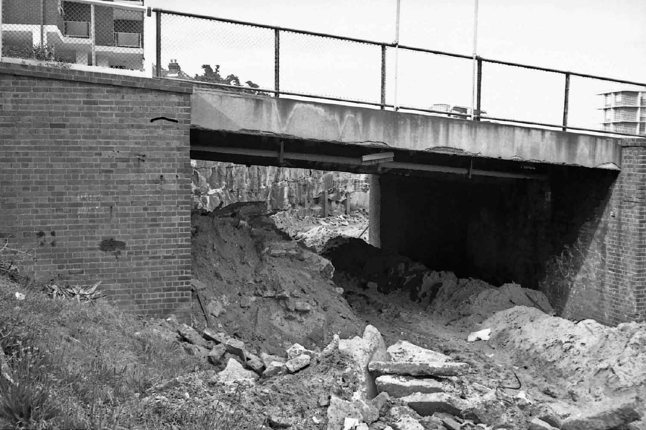
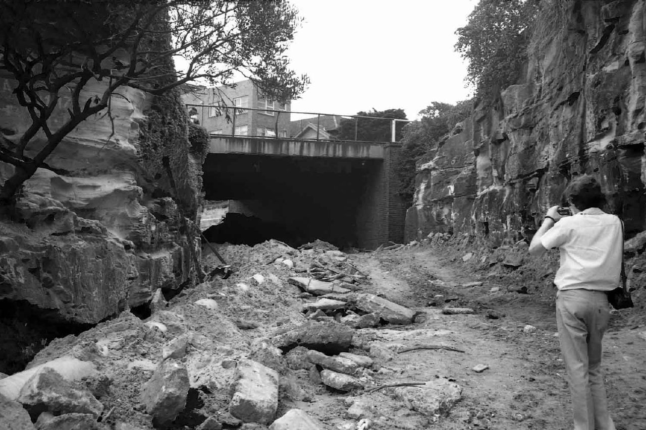
Bondi Beach once had a dedicated tramway...
...with cuttings and bridges and curves.... and now we have buses and cars. Oh well. And the tramway reservation? Gone. Filled in. Some of it became park, some sold off to developers. Like a lot of Sydney's reserved track, just gone.
Here are some snaps I took in the mid-70s when the in-filling was taking place...
Friday, April 20, 2012
Sydney by Street Directory - c. 1920-1940 - a video
This is what happens when I spend some time with my old Sydney street directories, a camera and a video editor... this is the full version, there are shorter ones on my youtube channel.
Monday, June 28, 2010
Some snippets of history: Turramurra, a northern suburb of Sydney
Some varied history and observations about Turramurra, a suburb in the north and west of Sydney, split by the north shore rail line and the Pacific Highway. Anecdotally the northern side of the suburb is the place to be if you happen to like big houses, big cars and expansive lawns and gardens. The Pacific Hwy was variously in parts called either Lane Cove Road or Gordon Road up to Pearces Corner, where Peats Ferry Road began.
Geological Sites - Especially around Sydney

Geological Sites - Especially around Sydney
TURRAMURRATurramurra, New South Wales - Wikipedia, the free encyclopedia
Lovers Jump waterfall. Lovers Jump (locally also known as Lovers Leap) is a waterfall with a significantly large pool at its base, on the northern side of Burns Road between Finchley Place and McRae Place. A pool at the base of the waterfall is not known to have ever dried up, even though the creek may periodically run dry. The relatively deep valley of Lovers Leap (Lovers Jump) Creek below the waterfall has an area of remant Blue Gum High Forest ecological community. Brush turkeys in groups of up to 4 or 5 lives along the creek and the birds are seen in McRae Place where nesting mounds have been built and chicks have emerged in recent years. Also known in the area are lyre birds, owls, lizards like the water dragon, water rat, eels, etc. No particular reason for the waterfall development here is apparent. The creek at the top of the falls is probably close to the top of the Hawkesbury Sandstone. Where McRae Place makes its first bend (to the east) shale has been met with in digging on the northern side of the road, and close downslope from here the sandstone outcrops. This is probably an accurate elevation point for the base of the Mittagong Formation. Opposite the entrance to McCrae Place, on the south side of Burns Road, building excavation in 2007 exposed weathered Ashfield Shale passing down into Mittagong Formation. Near here was Irish Town. For a time this was an isolated community of orchardists who settled after 1850, with frequent intermarriage and picnicing at the Lovers Leap waterhole (fide Ku-ring-gai Historical Society). Irish Town is remembered by the small "Irish Town Grove" creek reserve between Bannockburn Road and Adams Street; although some accounts state that much of North Turramurra was known as Irish Town. The orchards are also remembered by the Orange Green park behind North Turramurra public school. This school was opened in 1914 to serve the community of orchardists, market gardeners and dairy farmers. In 1920 fruit fly proved disastrous to commercial orchardists on the North Shore
Turramurra is a suburb on the Upper North Shore of Sydney, in the state of New South Wales, Australia. Turramurra is located 17 kilometres north of the Sydney central business district, in the local government area of Ku-ring-gai Council. North Turramurra and South Turramurra are separate suburbs.[1]Turramurra, New South Wales - Wikipedia, the free encyclopedia
Early settlers referred to the area as Eastern Road until the name Turramurra was adopted when the railway station was built here in 1890. One of the early local landmarks was Ingleholme, a two-storey Federation home in Boomerang Street. It was designed by John Sulman (1849-1934) as his own home and built circa 1896. The house was part of the Presbyterian Ladies College for some time afterwards and is now on the Register of the National Estate. It is notable as an example of John Sulman's style.[2] The first post office opened in 1890. The Hillview estate was marked for heritage listing.[3] Another humble landmark is St Andrew's in Kissing Point Road, which is an example of the Federation Carpenter Gothic style.Ku-ring-gai Historical Society - Local history - Turramurra
Turramurra is an Aboriginal word meaning ‘high hill’ or ‘big hill’. When the railway was opened on 1 January 1890 the suburb was called Eastern Road after the border of one of the major estates in the area. This was changed to Turramurra on 14 December 1890 as it was thought more appropriate the suburb have an Aboriginal name.
Turramurra is a large suburb, extending from the Lane Cove National Park in the south to Ku-ring-gai Chase National Park in the north. Both these parks govern the boundaries of North and South Turramurra. The township of Turramurra is divided from Wahroonga by Finlay Road, Cherry Street, Brentwood Avenue then east to Eastern Road. From here it continues along Eastern Road to its junction with Burns Road, to swing south to a branch of Cowan Creek. On the Pymble side, the boundary goes south to Pentecost Avenue, west to Bobbin Head Road, then south again to the Pacific Highway. It crosses the highway, runs down along the edge of Rofe Park to end of the Lane Cove River...
In 1822 Thomas Hyndes leased and subsequently purchased 2,000 acres north of Robert Pymble’s grant. Turramurra was part of this lease, known afterwards as The Big Estate Lease.
Labels:
Coastal NSW,
Suburbs of Sydney,
Sydney,
Turramurra
Some snippets of history - lime, mills, dams, silting and sewage : the Cooks River, Sydney
I've previously mentioned that the Riley Street (Surry Hills) indoor board velodrome was shifted holus-bolus to Canterbury - splinters and all - which is remarkable enough, but there's more to Canterbury than just an old velodrome site, a station, a bus terminus and a horse racetrack. There's also a river - the Cooks River - that runs from Botany Bay to Canterbury and further westward. It was of course once a working natural river with meanders but dams, industry and concrete culverts put an end to much of the "natural-ness".
I'll post a map of the Tempe dam soon, but the article quoted below makes the location clear enough. The river was dammed to poor effect at Tempe and at Canterbury. The flood of the late 19th century wiped out much of the market gardening and led to grand schemes of tunnels and canals, of which only Alexandra Canal really came to pass. The river's mouth was also moved to accommodate an enlargement of Sydney's Mascot airport. You can find maps of that elsewhere on this blog.
City of Canterbury - History of Cooks River
I'll post a map of the Tempe dam soon, but the article quoted below makes the location clear enough. The river was dammed to poor effect at Tempe and at Canterbury. The flood of the late 19th century wiped out much of the market gardening and led to grand schemes of tunnels and canals, of which only Alexandra Canal really came to pass. The river's mouth was also moved to accommodate an enlargement of Sydney's Mascot airport. You can find maps of that elsewhere on this blog.
City of Canterbury - History of Cooks River
Descriptions of the country along Cooks River by the early explorers were not optimistic about the land's potential for food production. Captain John Hunter and Lieutenant Bradley both mentioned the shallowness of the water and the large swamps, in place of Cook's 'fine meadow', so it was to the alluvial terraces of the Parramatta and Hawkesbury Rivers that the farmers of the colony went. The Reverend Richard Johnson, however, took time out from his chief mission - first pastor to the settlements in New South Wales - to cultivate his properties, among them being a grant of 250 acres at Canterbury (stretching along the river from present Garnet Street, Hurlstone Park to Croydon Avenue, Ashbury). There is no evidence that he ever lived on his 'Canterbury Vale' farm. But with the help of an overseer, several convicts, and labourers paid by himself, he cleared and planted several acres. Yields were high enough from his estates for him to be described by Watkin Tench as 'the best farmer in the colony'. When the property was sold to William Cox in 1800, it included livestock, two acres of vineyard, and another acre of orchard with orange trees, nectarines, peaches and apricots.City of Canterbury - History of Cooks River
Major industries of the area were fishing and lime burning, especially around the mouth of the river and in Botany Bay. In a new settlement, three basic needs had to be satisfied: the need for food, the need for water, and the need for shelter for the inhabitants. Although brick-making clay was abundant, nothing could be found for a long time to hold these bricks permanently together. Lime, essential in making mortar, was in such a short supply that most brick buildings collapsed in a heap of rubble as soon as the walls were leant on, and Governor Phillip constantly appealed for limestone to be sent out as ballast in the ships from home. Shell middens left by the aborigines on the shores of the Cooks River and Botany Bay proved to be a vital source of lime, and many colonists managed to make a living gathering the remnants from thousands of years of aboriginal meals to supply their kilns.City of Canterbury - History of Cooks River
Cornelius Prout built a punt to give him access to his property, Belle Ombre (along the river from today's Canterbury Road to Clissold Parade, Campsie); a punt also operated somewhere about the same time at Undercliffe, known as Thorpe's Punt. This was a link on one of the roads to the Illawarra district. Fords existed at Tempe and further up the river, but with the spread of settlement and eventually industry, permanent bridges were needed.City of Canterbury - History of Cooks River
A B Spark, Leslie Duguid, and F W Unwin all built country houses beside Cooks River in the late 1830's, and by 1840, three bridge crossings were in use; Unwin's Bridge at Tempe, (to give access from Sydney to his house, Wanstead); Prout's Bridge, replacing the punt, at Canterbury; and the dam at Tempe, continuing the line of Cook's River Road (Princes Highway) past the house of Alexander Brodie Spark.City of Canterbury - History of Cooks River
A second dam was built to serve the river's first manufacturing industry: the Australian Sugar Company's refinery at Canterbury; this location was selected because of the need for ample supplies of water in processing.Cooks River - Wikipedia, the free encyclopedia
The Sugar House is placed within one hundred feet on Cook's River which is shortly expected to be fresh water, the Dam being quite close and is built of beautiful white sandstone. (Sydney Herald, 4 October, 1841)
The Cooks River is a 23 kilometre long urban waterway of south-western Sydney, New South Wales, Australia emptying into Botany Bay. The course of the river has been altered to accommodate various developments along its shore. It serves as part of a stormwater system for the 100 square kilometres of its watershed, and many of the original streams running into it have been turned into concrete lined channels. The tidal sections support significant areas of mangroves, bird, and fish life, and are used for recreational activities.Geological Sites - Especially around Sydney
The river was discovered by Captain James Cook in 1770 but it was not until 1793 that any permanent settlement began to occur along it. The first bridge was erected here in 1810, give access to the southern bank of the river for timber getting. It was then a limit of recreational excursions from Sydney.
With the degradation and growing inadequacy of Sydney's Tank Stream water suppy by 1826 the Cooks River was considered as a possibly fresh water supply. A dam was built across it here for that purpose, in the 1830s. The work was mainly completed in 1839-1841 using convict labour. It was considered that floods might flush out the saline water and give allow a fresh supply behind the dam (cf. in a flood of 1889 the river flowed 10 above the dam at Tempe). However, the dam was unsuccessful, as the water remained saline and the main effect of the dam, because of the increase of upstream polluting industries, was to generate a cesspool. Most of the fresh water remained dammed behind the later dam at the Sugar House at Canterbury, but that dam water too was often in a very offensive condition. There was an outbreak of typhoid fever affecting swimmers in 1896. The Tempe dam was lowered to improve flushing, and eventually demolished entirely.
My list of Sydney's race tracks and circuits.
or checkout my list of Sydney and surrounding airstrips and airports.
Labels:
Canterbury,
Coastal NSW,
Cooks River,
Marrickville,
Sydney,
sydney airport,
velodromes
Tuesday, June 22, 2010
Where was....
Where was Amaroo Park? North west of Sydney, in Annangrove. Now redeveloped.
Where was Oran Park? South west of Sydney, now redeveloped. Near Camden and Narellan.
Where was Catalina Park?The track remains but is unusable for motorsport (and unsafe anyway!). Was used for rallycross but looks abandoned now. The track can be ridden (bicycles) or walked.
Where was Maroubra Speedway? On the hills above the beach, to the east of Anzac Pde.
More to come....
Here is an updated list of Sydney's airports.
Where was Oran Park? South west of Sydney, now redeveloped. Near Camden and Narellan.
Where was Catalina Park?The track remains but is unusable for motorsport (and unsafe anyway!). Was used for rallycross but looks abandoned now. The track can be ridden (bicycles) or walked.
Where was Maroubra Speedway? On the hills above the beach, to the east of Anzac Pde.
More to come....
Here is an updated list of Sydney's airports.
Tuesday, June 15, 2010
The type of emotional rhetoric used to close an airport - in this case Hoxton Park but today's events will lead to more calls for Bankstown to close
It's obviously a traumatic and sad event when an aircraft crashes with a loss of life - and we don't need local agitators jumping on the bandwagon. But they will. Of course aircraft don't crash on approach or departure from Bankstown as regularly as cars and trucks crash on our roads - far from it - yet the fear campaign will be all about the unsuitability of having an airport adjacent to houses, schools and offices. It may be a statistically low risk but it's an emotive issue, especially so immediately after a crash occurs. It's ghoulish and sad that people will use this event in a manipulative way, but it will add to the aircraft noise debate (arguably the real issue) and may eventually cause Bankstown to be reduced in scope, or to close. Perhaps.
Sometimes issues just mount up and force a hand. Further to the west of Sydney Hoxton Park has closed, at least partly because of the fear campaigns of elected parliamentary members just "doing their job", and partly in aid of a bigger transport picture involving airport privatisation and development. The end result is another airport closure, putting more pressure on existing facilities - like Bankstown.
Now Bankstown airport has been around a long time (planned in 1929 but built during WWII) and pre-dates much of the industrial and residential development that now surrounds it. Indeed it is hemmed in and further growth is impeded. And as Sydney's airfields have closed - many of the WWII airfields such as Castlereagh or Fleurs lasting only into the '50s or at best early '60s - others have taken up the slack, like Bankstown, Camden, Wedderburn and The Oaks (despite the quote below very much an active field) . Be they the late lamented Naval Air Station at Schofields or the more recent closure of Hoxton Park the loss of landing strips forces light to medium aircraft users, owners and operators into either more distant airfields like Wedderburn or The Oaks or into busier ones like Bankstown. And we aren't actually opening any new ones, are we?
By the way I'm hardly a silvertail (read below for the bald faced rhetoric), having grown up in Marrickville in the 60's. I don't fly any more but the point is that private pilots can come from any socio-economic background. That's what our egalitarian society is all about - opportunity coupled with fairness and social mobility. Or is that just rhetoric as well?
Hoxton Park Airport - 07/05/2002 - NSW Parliament

Sometimes issues just mount up and force a hand. Further to the west of Sydney Hoxton Park has closed, at least partly because of the fear campaigns of elected parliamentary members just "doing their job", and partly in aid of a bigger transport picture involving airport privatisation and development. The end result is another airport closure, putting more pressure on existing facilities - like Bankstown.
Now Bankstown airport has been around a long time (planned in 1929 but built during WWII) and pre-dates much of the industrial and residential development that now surrounds it. Indeed it is hemmed in and further growth is impeded. And as Sydney's airfields have closed - many of the WWII airfields such as Castlereagh or Fleurs lasting only into the '50s or at best early '60s - others have taken up the slack, like Bankstown, Camden, Wedderburn and The Oaks (despite the quote below very much an active field) . Be they the late lamented Naval Air Station at Schofields or the more recent closure of Hoxton Park the loss of landing strips forces light to medium aircraft users, owners and operators into either more distant airfields like Wedderburn or The Oaks or into busier ones like Bankstown. And we aren't actually opening any new ones, are we?
By the way I'm hardly a silvertail (read below for the bald faced rhetoric), having grown up in Marrickville in the 60's. I don't fly any more but the point is that private pilots can come from any socio-economic background. That's what our egalitarian society is all about - opportunity coupled with fairness and social mobility. Or is that just rhetoric as well?
Hoxton Park Airport - 07/05/2002 - NSW Parliament
Mr LYNCH (Liverpool) [4.41 p.m.]: I ask the House to note as a matter of public importance Hoxton Park Airport and the surrounding suburbs. Hoxton Park Airport is located within my electorate and it is the subject of considerable controversy. Both in terms of the safety of residents living around it and in the amenity of their neighbourhoods, a substantial number of people have been calling for the airport's closure. The suburbs surrounding the airport include Cecil Hills, Green Valley, Hinchinbrook, Hoxton Park and West Hoxton. I have called for the closure of the airport on previous occasions, and I restate that call today. I have raised this matter on a number of occasions in this House. Indeed, I debated an urgent motion on the matter in 1999. It is appropriate to raise the matter again today because only several weeks ago there was a further accident at the airport.
Hoxton Park Airport is a general aviation airport. It covers 85 hectares and has one sealed runway that is 1,098 metres in length. It is open 24 hours a day, seven days a week. However, circuit training is restricted to between 6.00 a.m. and 11.00 p.m. on Mondays to Fridays, 6.00 a.m. to 10.00 p.m. on Saturdays, and 6.00 a.m. to one hour after last light on Sundays. It caters to both fixed-wing and rotary-wing aircraft, that is, planes and helicopters. It is usually busier on weekends than on weekdays, which says something about the people who are using the airport to train. As I understand the evidence, an average of about six or seven planes are in the air around the vicinity of the airport at any given time.
The airport was originally constructed in about 1942 as part of a group of airfields to be used as aircraft dispersal fields in anticipation of a Japanese air attack. Others included Menangle, Bargo, the Oaks, Wallgrove, Fleurs, St Marys, Castlereagh, Pitt Town and Ettalong. Interestingly enough, none of those airfields is currently operating as an airport. RAAF pilots also used Hoxton Park Airport for training purposes and the like. After the war the airport was leased to the Hardy Rubber Company for use as a tyre test track. Eventually its use as an airport was resumed, but its current use is very different to what it was then. It is now used overwhelmingly for training purposes.
Monday, June 14, 2010
Wedderburn, Wallacia, Wilton: the hidden airfields of Sydney starting with "W"
I've become a bit obsessed with the subject of the airports, airfields and landing strips that either exist now or existed once in the greater Sydney region. You may have noticed a few posts on this subject recently... well here's another one!
I have previously mentioned Wedderburn. Wedderburn airfield has a single runway, 17/35 measuring approximately 950 m (3,120 ft) long. There are some interesting historical pics in the Sport Aircraft Club's gallery from the Campbelltown City Council collection. It's a post-war private field that has grown somewhat since closure of Hoxton Park.
I should mention Wallacia. Wallacia airstrip was on Park Rd, Wallacia. It is no longer in use, indeed it's not really visible to me at all - not a trace! I also have found little historical information on ownership or use. I do know that it was adjacent to a Wildlife Park (Bullen's Animal World) and was used as carparking during a music festival in 1971.
Wikipedia says this about Bullen's Animal World:
Bullen's Animal World was a circus style theme park located at Wallacia on the outskirts of Sydney. Its address was 11 Park Road, Wallacia. It was opened in 1969 by Stafford Bullen, the son of circus founder Alfred Percival Bullen, and operated until 1985.
And there's Wilton, of course, an active former WWII "dispersal strip" with 3 crossing runways in a triangular arrangement. At least 2 runways are visibly operational. Wilton is a skydiving centre with some growth occuring since the closure of Hoxton Park airstrip. Wilton is located along the Hume Motorway, south-west of Sydney.
Wilton was considered as the site for the "2nd" major airport for Sydney but after much opposition and consternation plus decades of indecision Badgery's Creek is the current formally selected and 'semi-funded' site. We'll see what happens, I guess!
I have previously mentioned Wedderburn. Wedderburn airfield has a single runway, 17/35 measuring approximately 950 m (3,120 ft) long. There are some interesting historical pics in the Sport Aircraft Club's gallery from the Campbelltown City Council collection. It's a post-war private field that has grown somewhat since closure of Hoxton Park.
I should mention Wallacia. Wallacia airstrip was on Park Rd, Wallacia. It is no longer in use, indeed it's not really visible to me at all - not a trace! I also have found little historical information on ownership or use. I do know that it was adjacent to a Wildlife Park (Bullen's Animal World) and was used as carparking during a music festival in 1971.
Wikipedia says this about Bullen's Animal World:
Bullen's Animal World was a circus style theme park located at Wallacia on the outskirts of Sydney. Its address was 11 Park Road, Wallacia. It was opened in 1969 by Stafford Bullen, the son of circus founder Alfred Percival Bullen, and operated until 1985.
And there's Wilton, of course, an active former WWII "dispersal strip" with 3 crossing runways in a triangular arrangement. At least 2 runways are visibly operational. Wilton is a skydiving centre with some growth occuring since the closure of Hoxton Park airstrip. Wilton is located along the Hume Motorway, south-west of Sydney.
Wilton was considered as the site for the "2nd" major airport for Sydney but after much opposition and consternation plus decades of indecision Badgery's Creek is the current formally selected and 'semi-funded' site. We'll see what happens, I guess!
My list of Sydney's race tracks and circuits.
or checkout my list of Sydney and surrounding airstrips and airports.
Labels:
airfields,
airstrips,
Campbelltown,
dispersal,
landing grounds,
Sport Aircraft Club,
suburbs,
Sydney,
W,
Wallacia,
wedderburn,
Wilton,
WWII
Last post on this for a while - gliding out of Camden - a potted history of that airport
Camden Airport is roughly 50km (by air) south and west of Sydney. Originally a private airfield, or perhaps paddock, it was seconded for RAAF use as No 13 Operational Base, Camden, early in WWII.
Camden airfield was constructed circa 1935 on what had become the Macarthur-Onslow family property. The actual original settlers in this area were indigenous, of course. Likely there were populations of Gandangara to the south, Darug to the north and Tharawal people to the east. Some evidence probably remains on the site.
Post-invasion and before the Macarthur-Onslow family moved in, circa 1812 around 400 acres of land beside the Nepean River was granted to Rowland Hassall. The property was named “Macquarie Grove” in honour of Governor Macquarie (who had of course granted Hassall the land). In 1877 however the land passed on, into the hands of the Hon. H.C. Dangar MLC (the Dangars were prominent players in the Colony). Dangar may have introduced a rifle range into the southern end of the property and may - possibly, by at least one account - also have established a racecourse (isn't there always a racecourse involved somewhere?) which remained on the site until the flying school began operations c.1938.
After Dangar the property passed through several hands until purchased by F.A. Macarthur-Onslow in 1916 - in his wife Lucy’s name - or was it Sylvia? (2 sources, 2 wives - hmmm.) So we should say Lucy/Sylvia bought it, but that's not how these things worked, is it?
Anyway, circa 1921 a remarkable Australian aviator of aircraft design fame, Edgar Percival returned home after service with the Royal Flying Corps and opened a small commercial aircraft business. Percival landed on the Macarthur-Onslow property in 1924, and proceeded to inspire the three Macarthur-Onslow sons, Denzil, Edward and Andrew to pursue aviation careers. A film was also shot on the property, involving horse racing and an AVRO 504 (piloted by Percival, apparently!)
With the help of H.E. Broadsmith they designed and built their own aircraft, the B4. Broadsmith was one of the partners (with Nigel Love) in an A.V. Roe (Avro) agency under the name of the Australian Aircraft and Engineering Company Ltd, based at Mascot.
Edward Macarthur-Onslow, a member of the Camden troop of the 1st Light Horse which used the pastures of Macquarie Grove as a parade ground bought his first plane, a Hornet Moth, in 1935 and this and the Comper Swift owned by brother Denzil were housed in a garage on the property. The family also established the Macquarie Grove Flying School in 1938.
Of cousre we all can guess what happened next. In 1939 the newly-christened Macquarie Grove Aerodrome (and hangars) were seconded - happily handed over, really, although the family expected it back - by the Commonwealth for war purposes. Work began on the airfield to clear approaches and install about 50 prefabricated huts. The 1st Light Horse Garrison moved in to patrol the aerodrome. Camden became home to perhaps seven squadrons that undertook training, anti-submarine, convoy escort, reconnaissance, general air and meteorological tasks. The squadrons included No 457 Spitfire Squadron which arrived in November 1942 and No 15 General Reconaissance Bomber Squadron (equipped with Beauforts), formed at Camden in January 1944. A substantial US Army Air Corp contingent was based at the airport as well.
Camden airfield was constructed circa 1935 on what had become the Macarthur-Onslow family property. The actual original settlers in this area were indigenous, of course. Likely there were populations of Gandangara to the south, Darug to the north and Tharawal people to the east. Some evidence probably remains on the site.
Post-invasion and before the Macarthur-Onslow family moved in, circa 1812 around 400 acres of land beside the Nepean River was granted to Rowland Hassall. The property was named “Macquarie Grove” in honour of Governor Macquarie (who had of course granted Hassall the land). In 1877 however the land passed on, into the hands of the Hon. H.C. Dangar MLC (the Dangars were prominent players in the Colony). Dangar may have introduced a rifle range into the southern end of the property and may - possibly, by at least one account - also have established a racecourse (isn't there always a racecourse involved somewhere?) which remained on the site until the flying school began operations c.1938.
After Dangar the property passed through several hands until purchased by F.A. Macarthur-Onslow in 1916 - in his wife Lucy’s name - or was it Sylvia? (2 sources, 2 wives - hmmm.) So we should say Lucy/Sylvia bought it, but that's not how these things worked, is it?
Anyway, circa 1921 a remarkable Australian aviator of aircraft design fame, Edgar Percival returned home after service with the Royal Flying Corps and opened a small commercial aircraft business. Percival landed on the Macarthur-Onslow property in 1924, and proceeded to inspire the three Macarthur-Onslow sons, Denzil, Edward and Andrew to pursue aviation careers. A film was also shot on the property, involving horse racing and an AVRO 504 (piloted by Percival, apparently!)
With the help of H.E. Broadsmith they designed and built their own aircraft, the B4. Broadsmith was one of the partners (with Nigel Love) in an A.V. Roe (Avro) agency under the name of the Australian Aircraft and Engineering Company Ltd, based at Mascot.
Edward Macarthur-Onslow, a member of the Camden troop of the 1st Light Horse which used the pastures of Macquarie Grove as a parade ground bought his first plane, a Hornet Moth, in 1935 and this and the Comper Swift owned by brother Denzil were housed in a garage on the property. The family also established the Macquarie Grove Flying School in 1938.
Of cousre we all can guess what happened next. In 1939 the newly-christened Macquarie Grove Aerodrome (and hangars) were seconded - happily handed over, really, although the family expected it back - by the Commonwealth for war purposes. Work began on the airfield to clear approaches and install about 50 prefabricated huts. The 1st Light Horse Garrison moved in to patrol the aerodrome. Camden became home to perhaps seven squadrons that undertook training, anti-submarine, convoy escort, reconnaissance, general air and meteorological tasks. The squadrons included No 457 Spitfire Squadron which arrived in November 1942 and No 15 General Reconaissance Bomber Squadron (equipped with Beauforts), formed at Camden in January 1944. A substantial US Army Air Corp contingent was based at the airport as well.
RAAF Station, Camden was handed to the Department of Civil Aviation (note - not the Macarthur-Onslow family, who remain a bit taken aback at this move) on 15 September 1946. Ownership subsequently transferred to the new, more commercially-driven Federal Airports Corporation in 1988. That's when the "user pays" principle really kicked in and pressure was put on existing users to make the most of their presence on the airport. Or move.
Further paper-based 'ownership' changes occurred in 1998 to Sydney Airports Corporation Ltd and then division of that body into a separate Camden Airport Ltd in 2001, pending privatisation (by long-term commercial lease) in 2003.
Here's a useful location map which may be found in the 2010 Camden Airport Master Plan (see link at end, if you must).
My first experience of Camden was as an aircraft-mad Marrickville kid growing up in the mid 1960s - and my recollection is much as the 1953 description below. Very much a "WWII RAAF airfield" feel with the gate house and raised gate, the house on the hill and the buildings on the hillside, the twisting road down to the hangars and so on.
Of course there was also the Camden Museum of Aviation, an absolute must-see at the time. Sadly the museum, like other hangar-based museums at the time, was "moved on" in recent years to make way for "real" aviation activity. I guess it was cheaper than building another hangar but the museum really hasn't re-opened since.
That's probably a Camden Aero Club DH Tiger Moth, circa 1969, right there.
My next recollection would be around 1976 or so, flying into Camden in a Cessna 150 and a Cherokee, practising touch-and-goes. I did taxi there, too, and the WWII-era RAAF Kittyhawk-width grooves were certainly for real.
And then again in the very late '70s or possibly early '80s (I really can't remember!) I took off and landed a German-built sailplane there, on a grass strip. As a powered-flying pilot I found a long, shallow and quite fast approach somewhat harrowing, especially given a successful go-around was unlikely!
Finally the airport had a complete revamp, new tower, the museum was booted out and eventually new private owners took charge. I haven't been there since.
Here's an historical gliding snippet. Click on the link to read it in full.
Southern Cross Gliding Club, Sydney
The aerodrome area was originally a race track owned by Arthur Macarthur-Onslow. In 1919 a film called "Silks and Saddles" was being made which required a race between a horse and an Avro 504K, and the Camden track was ideal for shooting this sequence... ...Camden became Australia's first private aerodrome. Edward Macarthur-Onslow became a great personality in aviation and formed the Macquarie Grove Flying School which by 1939 employed more than thirty people in the workshops at Camden Aerodrome servicing about a dozen aircraft at all levels, including engine overhauls and propeller manufacture.Camden still looked much like that in the late '60s and early '70s, sentry box, boom gate - the lot. However things changed as a new control tower was built and the old museum was (im)politelty moved on.
When World War 2 came, Edward Macarthur-Onslow made the aerodrome available to the Commonwealth Government "for the training of Australian war pilots". Then the RAAF moved in, and then the Americans, the elegant Macquarie Grove House on the aerodrome was turned into an officer's mess and the sergeants made even more of a "mess" of Hassell Cottage at the top of the hill... ...What the gliding people saw in 1953 was an almost intact example of a WW2 Air Force training base. Near the top of the hill at the bend in the road was a sentry box with boom gate and khaki painted wooden huts stretched in rows right down the hill to the hangers which were full of unwanted aircraft, mainly Avro Ansons... ...That so much should have remained in 1953 was remarkable. But no one else visited the place and it was like an old movie set of WW2. The gliding people were even given the use of a few wooden huts.
Currently there are 17 hangar buildings and 100-150 movements per day, peaking at about 200 (2010 figures). There are 2 main runways, 06/24 (main, lit, 1464m) and 10/28 (grass, unlit, 723m) plus 2 grass gliding strips in parallel (or almost!) to the main runways. Most aircraft movements are single-engined but the glider movements are not counted so who knows for sure?
I have some more Camden pics on Flickr (account: gtveloce).
An extra note here is the training status of Camden:
Camden, NSW is recorded as being the only Central Flying School (CFS) in the
country as at December 1941.34 This seems to be the case as sources claim the
CFS moved to Tamworth RAAF Base.35 Table 1 therefore lists the CFS as the
principal function at Tamworth.
There's even a master plan with more maps and a wealth of detail.
My list of Sydney's race tracks and circuits.
or checkout my list of Sydney and surrounding airstrips and airports. 
Subscribe to:
Posts (Atom)