Monday, June 27, 2011

Kensington Racecourse: Wilson's 1926 directory

Kensington_Wilsons 1926_287 by gtveloce
Kensington_Wilsons 1926_287, a photo by gtveloce on Flickr.
Last one on Kenso, and it's the racecourse that became a university - of NSW, to be precise. Kensington racetrack was a pony course adjacent - probably too close - to the Randwick horse racing track. Randwick won out politically and the Kensington ponies were shifted south to Ascot (or Mascot, if you like). The Old Tote building became a theatre under NIDA and the rest of the land became the UNSW.

There are also some interesting tram formations on this 1926 map, including the Dacey Ave line and the loop on the other side of Anzac Parade from the racetracks.


View Larger Map

or checkout my list of Sydney and surrounding airstrips and airports

Kensington, Heffron and Randwick: Wilson's 1926

Kensington_Wilsons 1926_288 by gtveloce
Kensington_Wilsons 1926_288, a photo by gtveloce on Flickr.
Lots of changes here since 1926. Long Bay Road becomes today's Malabar Road and the trams have gone, of course. What is now Heffron Park is not yet split by Fitzgerald Ave and plenty of houses are missing. Also the old Randwick rifle range has yet to shrink or lose its tram link (along Araluen Street, below).


View Larger Map

Sunday, June 26, 2011

Long Bay: Wilson's 1926 street directory

Long Bay_Wilsons 1926_289 by gtveloce
Long Bay_Wilsons 1926_289, a photo by gtveloce on Flickr.
Nice advert for a dream home in Randwick... wonder if that house still exists?

Also noted is the tram line up Perry Street, right onto Bunnerong Road, keeping well to the left before crossing the road onto the right side and finally enjoying some reserved track. I guess the road traffic was fairly light in any case but it seems odd to cross sides like that....

St Peters: Wilson's 1926 street directory

St Peters_Wilsons 1926_290 by gtveloce
St Peters_Wilsons 1926_290, a photo by gtveloce on Flickr.
Note 'King Street' for today's Princes Highway, the dam at the Cooks River and the cricket ground on King St near Station Street. Also the advert for lime from kilns on Canal Rd is interesting.

Thursday, June 9, 2011

An interesting historical note about Narara, the sunken steamer off Barrenjoey - not the suburb. Or is it?

A snaky tale of ships and sea... well, in part, anyway. In summary, "Narara" appears to mean "black snake" in local Aboriginal language and it is a name that has adorned a ship that sank off Barrenjoey as well as the Gosford suburb. I note that Wikipedia hasn't updated its spelling of Barrenjoey since 1909... perhaps that is the preferred spelling? 

Narara (ship) - Wikipedia, the free encyclopedia
The Narara was a wooden carvel screw steamer built in 1900 at Jervis Bay, that was wrecked when it sprang a leak whilst carrying general cargo between Sydney and the Hawkesbury River and was lost at 2 ml SE off Little Reef Newport near, Barranjoey, New South Wales on the 29 May 1909. The vessel commenced her runs from Sydney Harbour to the Hawkesbury River in January 1900 and continued on this run till the time of her final 1909 sinking. During 1903 the vessel was burned to the water line and sank at its mooring only to be refloated and rebuilt and started back on the same run.

Narara, New South Wales - Wikipedia, the free encyclopedia
The name 'Narara' can be traced back to the local Aboriginal term for 'black snake', which appears on the official emblem of Narara Valley High School and the scarf of 1st Narara Scout Group.[1][2]

Narara, New South Wales - Wikipedia, the free encyclopedia
Narara largely consisted of orchards and small mixed farms. Water from the small dams that used to be accessible from Narara Creek Road was piped in wooden piping across Narara Creek to the Railway station to supply steam trains. The dams were also a popular swimming spot especially when the ladder and walkway still existed on the lower dam wall.

Sunday, May 8, 2011

Bo Diddley plays Henson Park, 1976

The legendary Bo Diddley once played Henson Park in Marrickville, NSW using a local backing band (whose name escapes me..! ). Support was Jeff St John and the Silver Studs, MC was Donnie Sutherland. I believe it was 1976. Luckily enough I was there to take these blurry pics...

FYI Henson Park was a rugby league football ground and before that a cycling velodrome and key venue for the 1938 Empire Games. It wasn't usually a rock venue....

Wednesday, April 27, 2011

Where Qantas hid its DC4 fleet

QF DC4 EDB Sydney 75_245 by gtveloce
QF DC4 EDB Sydney 75_245, a photo by gtveloce on Flickr.
It must have been a tad embarrassing as well as expensive (and arguably romantic, in a way) for Qantas to have to maintain such old aircraft well into the jet age.

Between trips to Norfolk Island's short grass strip the old birds were maintained in the hangars furthest from any passenger terminal but plainly visible to anyone driving from the domestic terminals to the "new" international terminal on the far side of the airfield. It was semi-hidden but by far the most interesting part of Sydney Airport in the 1970s...

Air transport in the 70s: QF DC4, 1977

QF DC4 1977_229 by gtveloce
QF DC4 1977_229, a photo by gtveloce on Flickr.
Perhaps even more surprising than seeing big 4-engined turbo-prop L188 Electras flying into Sydney Airport in the 1970s was seeing (and hearing!) these 4-engined piston and prop-driven Douglas DC4 airliners in regular service from Sydney to Norfolk island!

They would often appear on the distant horizon to the east and north of where I was at Marrickville and lumber their way onto a short final approach to runway 16, making a left turn late over Sydenham. Presumably they were a slow-moving nuisance for the faster jets and were "hurried up" by air traffic control.

Air transport in the 1970s - Ansett L188 Electra

Ansett L188 Electra 76_918 by gtveloce
Ansett L188 Electra 76_918, a photo by gtveloce on Flickr.
Excuse the blur but it was hand-held after dusk!! Point is that it's an L188 Electra, one-time workhorse for TAA and Ansett, forced to serve out its days carrying cargo at night. Sydney then (as now) had a curfew on jets so "quieter" prop-driven aircraft did the night-time shifts. It extended the life of this Ansett Electra, which was retired from passenger duties in the early 1970s.

I remember both TAA and Ansett Electras swooping in from the south, joining the 16 approach quite late, over Marrickville or even Sydenham in order to 'nip in' before a bigger jet. They often soared over my head, one following the other in the 2-airline parallel timetable days.

This particular shot was taken in 1976, close to final retirement from the fleet.

A wet Coogee Crit, 1987

Coogee Crit 1987_040 by gtveloce
Coogee Crit 1987_040, a photo by gtveloce on Flickr.
Well I think it was '87. It's the Coogee crit stage of the Bank Race, anyway, which held criteriums and road stages in and between various towns in Queensland and NSW. Some promising guy named Jan Ullrich won it overall one year...

or checkout my list of Sydney and surrounding airstrips and airports

Austin in a Marrickville Street circa 1948

Austin 02 by gtveloce
Austin 02, a photo by gtveloce on Flickr.
Snazzy Austin caught in a Marrickville Street around 1948 or thereabouts.

Sunday, January 23, 2011

Some notes on Camperdown and its Town Hall

Camperdown Municipality went insolvent to the extent that its Town Hall was sold off by the Sheriff in 1909. The Town Hall itself was (seemingly) in "George Street" according to public notices of that time in the Sydney Morning Herald - but there is no George Street in Camperdown these days. There is one in nearby Erskineville, though. Or maybe 'George St' has been renamed? Other records suggest that the Town Hall was between King and Bishopgate Streets, and that's entirely on the other side of Newtown, towards Parramatta Road - where we actually expect to find Camperdown nowadays. Otherwise I'll just keep looking...

UPDATE: Found it! George Street was (of course!) renamed - it's now Parramatta Road. The Camperdown Town Hall was beside the primary school, corner of Mallet Street and Parramatta Road.

Records of Councils Absorbed by Sydney City Council - City of Sydney
1909
Sydney City Council (known as the Municipal Council of Sydney until 1949) took over the small and struggling Municipality of Camperdown.
Records of Councils Absorbed by Sydney City Council - City of Sydney
1968
The City lost most of the areas it had acquired.
Part of Camperdown (west of about Church Street/Mallett Street north) and part of Newtown (west of King Street) were transferred to the Municipality of Marrickville.
ARCHIVE - CAMPERDOWN
On 9th August, 1803 an area of land was granted to Thomas Rowley. Part of that grant later became the Kingston estate. Australia Street is marked on subdivision maps for the 1860s in the huge area known as North Kingston estate. Part of the street was in the Camperdown Estate. However, there would have been people residing where Australia Street now is before the street existed. A few streets south there was a very large land grant and there were people living in scattered cottages around this area.
ARCHIVE - CAMPERDOWN
The Municipality of Camperdown was formed in 1862, taking in the Parramatta Road end of Australia St. It was dissolved in 1908, at which time the area was absorbed by the City of Sydney. Newtown Council was formed in 1863, taking in the King Street end of Australia St. Newtown Council held their first meeting in 1865, one of the councillors appears to be a property owner (but not occupant) in Australia Street - Conley (or Connelly, who later became chairman). It was abolished in 1949 and the area was also absorbed by the Sydney City Council. In 1968 the area was carved up between Marrickville Council and (South) Sydney Council. In 1988 the area came fully under Marrickville.
Marrickville Council - History of Suburbs
Camperdown was named in 1806 by Governor William Bligh, who was granted an estate there of 97.1 ha (240 acres). Bligh was decorated for his role in the British naval victory against the Dutch at the Battle of Camperdown (Kamperduin) in 1797. Kamperduin, literally the Dunes of Kamp, is the name of a north Holland village, near the North Sea.

Camperdown was a separate municipality from 1862 to 1908.

Camperdown Cemetery, established in 1848, is one of the oldest European burial sites in New South Wales. The first interment was Sir Maurice O"Connell, son in law of Governor Bligh. The vault also contains the remains of his grandson, Richard Murray O'Connell.
Victoria Park, Camperdown - City of Sydney
Victoria Park, Camperdown

Victoria Park is at the junction of City Road and Parramatta Road adjacent to the University of Sydney. Both roads began as walking tracks in the 1790s, leading from Sydney to Botany Bay and Parramatta. This was the site of some of the earliest land grants in the colony in 1789 when 1000 acres was reserved to provide farmlands and pasture to support church, government and school officials. Early names for the area included the Kangaroo Grounds and Parakeet Hill.


Wednesday, September 8, 2010

Secrets of Mann Street, Gosford. The old waterfront, the Regal theatre site and more

Not exactly Sydney but close enough and inextricably linked both now and in the past... there's an excellent heritage walk on the Gosford Council website but it lacks a few current maps and images... so here are some excerpts with Google Maps and Streetview images added.... and remember to check out the GCC site for additional detail (including some marvellous old photos).

Mann Street South Heritage Walk — Gosford City Council
Gosford Park was dedicated on 15th January 1886. At that time the Park was a bare paddock. A rotunda for band recitals was added much later. This Park sat directly above Brisbane Water in the early days. The land immediately below the Park is all reclaimed from Brisbane Water. The practice ovals at the rear of the 1954 Gosford Public School were once all part of Brisbane Water. Georgiana Terrace marks the northernmost place Brisbane Water once reached. Around 1911, spoil from dredges was piled up on the water's edge, to create "Waterside Park". Later projects led to further reclamation and the building of Dane Drive. Vaughan Avenue was once named Wharf Street.
Mann Street South Heritage Walk — Gosford City Council
This part of Mann Street was once comparatively busy, with a conveniently located pub and General Store waiting for travellers to and from Sydney, and a Post and Telegraph Office. Steamship travel was the fastest and most comfortable means of getting to Gosford prior to the coming of the railway in 1887. George Watt sold tickets for the Parramatta River Steam Company from his two-storey weatherboard building. Watt's Gosford Emporium sold boots and shoes, ironmongery and crockery, groceries, drapery, meat safes and scrubbing boards amongst other things. With the railway station being built further north along Mann Street, during the 1880s, the businesses began to gravitate towards it.
Mann Street South Heritage Walk — Gosford City Council
A casual look at the front of this building (which a late friend described as " late 20th century brutalist!) would lead you might think that there was nothing historic about it at all. Walk to the northern end, and look east. You will see that the awful red brick front of the building hides a largely intact Victorian building. Along Mann Street there are some lovely old buildings hidden behind very unflattering 1950s & 60s facades.

The Post and Telegraph Office, and adjacent residence, were originally long and low single storey structures designed by James Barnet. In 1891 a second storey was added to the main Post Office. The building has had further alterations from 1908 to 1953, culminating in the building you see before you.
Mann Street South Heritage Walk — Gosford City Council
looking west directly across the street is the site of the Old Gosford School of Arts. Built in 1888, the Gosford community was very proud of this building. It featured a library, reading room, large meeting room, Municipal Chambers and a hall capable of seating 250 people. Travelling theatrical companies, magicians, illusionists and a blind concert group gave concerts in the hall. Travelling picture showmen would bring their wares to the people before the establishment of permanent cinemas in town. In 1927 the School of Arts burnt down. The hall was rebuilt on the old foundations. On the northern side facing Georgiana Terrace can be seen remnants of the old painted signage for Council offices. It is now used as a teachers' resource centre.
Mann Street South Heritage Walk — Gosford City Council
The original Gosford watch-house was built in Donnison Street in 1827, near today's Workcover building site. It was a three-roomed shingle-roofed slab timber structure that quickly became inadequate for its purpose. Around 1833 the first Gosford courthouse was added.

In 1849 the "new' Gosford Court and Police Station was built in Mann Street. It cost 345 pounds, and consisted of a courthouse, clerk's room, magistrate's room, two cells, a constable's room, and a yard. By the mid 1860s the building was in need of major repair. The northern end of the complex was extended in 1892. A brick charge room and offices were added in 1928 to the southern end. If you look closely you can see evidence of the various additions. From Georgiana Terrace you can see the original gaol cells. Over the front entrance you can still see the wrought-iron gas lamp holder. In the 1970s, police working in the old station were fed up with outdated facilities. Plans for the demolition of the building were halted, and a variety of historical and arts groups put their hands up to occupy the site. The new Gosford Police Centre was opened in June 1983. The new courthouse in Donnison Street opened in August 1987.
Mann Street South Heritage Walk — Gosford City Council
Henry Helman designed the Brisbane Water County Council building that was completed in 1957. The town was very proud of the project, and it featured local sandstone fascia provided by Gosford Quarries, and many fittings and furnishings from local companies. The meeting rooms were wood panelled, and the mechanism for operating the clock tower was controlled from a bookcase shaped to reflect the design of the outer building and clock tower. The old County Council building was briefly the home of the Northern Eagles football team in the late 1990s. The Spurbest proposal for the site includes the retention of the County Council facade.
Mann Street South Heritage Walk — Gosford City Council
The number and longevity of cafes in town reflect the passing trade in tourists and travellers who used to be directed through Gosford along the old Pacific Highway. PNA House stands on Jephson's Corner. Horace Jephson was a tobacconist and hairdresser who built his store on the site in 1907. A later extension was added in 1913. Walter Buscombe was an early occupant of the site before Jephson. Fred Cohen had a drapery and grocery store next door in the early 1910s. Old photos show that these two buildings were rather lovely in their time.
Mann Street South Heritage Walk — Gosford City Council
the Imperial Centre now stands on Sterland's Corner.
Mann Street South Heritage Walk — Gosford City Council
Shepherd's Corner was where William Street meets Mann Street
Mann Street South Heritage Walk — Gosford City Council
Where the Commonwealth Bank stands today was known as Hill's Corner. The corner was previously known as Campbell's Corner, after the owner of shops in the 1910s. Campbell's shops were destroyed by fire in November 1914. Campbell rebuilt on the site, and soon after sold to Hill. Hill's Corner Chambers were notable as the first "modern" mix of shops, businesses and professional rooms, with three-way garage. Fire destroyed the building in November 1933.
Mann Street South Heritage Walk — Gosford City Council
In 1937 a new and luxurious theatre, the Regal, was opened. It was designed in the Art Deco/Moderne style, and was as good as any city cinema of the period. The opening programme was the Janet Gaynor and Frederic March movie A Star is Born. Local workmen were used on the theatre that featured "plate glass and polished maple doors", "a foyer of terrazzo", 20,000 pounds worth of RCA sound equipment, and a "crying room" where mothers and infants could enjoy films without disturbing other patrons.
or checkout my list of Sydney and surrounding airstrips and airports

Wednesday, September 1, 2010

Diggin' history: quarry railway from Fairfield to Prospect, 1940

Well it's back to the maps for me. I knew there was a private railway from Fairfield station to the blue metal quarries at Prospect, I just couldn't put my finger on where I had seen reference to it. And here it is in the 1940 Robinson's Street Directory, showing it starting at Fairfield and running as a tram line beside the roadway for most of the distance to Windemere under the name of "Sydney And Suburbs Blue Metal Company". Of course another private railway - or tramway if you prefer - ran to the northern side of the same area from Toongabbie.

(And yes, I have corrected "1926" to "1940".)


The Toongabbie tramway is here.

Monday, July 19, 2010

My take on maps and copyright law in Australia - just for the historical record of course

This is a blog that dwells somewhat on local Sydney history - you may have noticed! And this post is partly an explanation and a disclaimer. In short: I do my best to respect copyright. That doesn't mean I agree with it - too often copyright hinders the creation of new material. Historically it has been important that new material reference and build on the past, and I remain in favour of that "fair use" principle. I don't believe in plagiarism or blatant misuse. Thus I respect the law as it stands, applied sensibly.

The longer explanation: wherever possible I cite sources for my material and avoid knowingly breaching copyright. Please let me know if I have stepped on your toes in that regard - it wasn't intentional.

Where I "sample" and mark recent material (with notes or circles) I do so for historical research purposes (ie 'study') only in accord with fair use under the act. I also believe that in all such cases I have only reproduced what is needed to obtain historical context and clarity, and that remains only up to or less than 
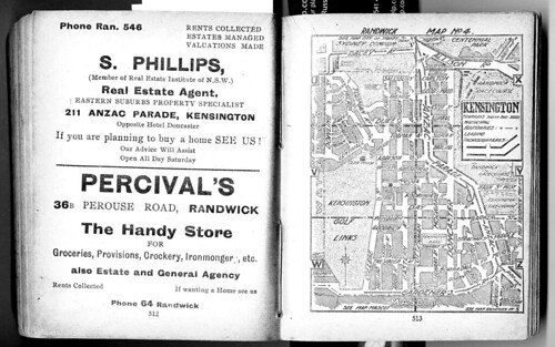
10% of the original work. This is achieved by cropping or blurring the remainder. Where I have overlayed one map upon another I have not in my view altered or added to the original material, rather I have simply layered one image over another. Where I have reproduced a full page of a street directory or other map either I consider it to be no longer covered by copyright, or to be less than 10% of the original (and complete) work. In that way I do distinguish between a complete work, being a whole publication, and sampled pages of  a complete work. I have not copied any street directory published after 1954 in its entirety, nor do I intend to do so. Again, if I have stepped on any individual copyright owner's toes please let me know. 

And here are some copyright snippets from other sites for comparison... 

The Australian Copyright Council site. A great source of up to date material.

National Library Of Australia | Copyright in maps
Maps published in or before 1954 are free of copyright. For maps published in 1955 or later by a government publisher, copyright lasts for 50 years after the end of the year the map was published. For maps published in 1955 or later by a non government publisher, copyright lasts for 70 years after the end of the year the map was published.
National Library Of Australia | Copyright in maps
Maps still in copyright can be copied for you in libraries under "fair dealing" exemptions of the Copyright Act 1968 for the purposes of research and study. However, you will need to demonstrate that you have followed your obligations under the Copyright Act. For a map in copyright a 10% portion of the map may be copied for research or study purposes only. In practice this usually means one A4 size portion (21cm x 30cm) of the map only. You do not need permission from the copyright owner to obtain a copy of a portion of a map as long as it is used for the purposes of research or study only. Permission is needed if you wish to copy the entire map, or if you intend to reproduce, display, publish or sell the copy.


Sunday, July 4, 2010

I can't resist some relic tunnels, railways and whatnot from NSW shale mines, can you?

Well I find it interesting, anyway. Been there twice, once staying overnight near Newnes. Shale oil mining was big business in the late 19th Century until the early 20th and a raft of mines sprung up in NSW. Tunnels, railway relics, oil refinery equipment - you name it, it's all there to be seen. This post is (you guessed it) about that shale mining. Follow the links to more detailed sites with pics.

Brian Ayling's Airly relics
From 1883 to about 1913, Kerosene shale or torbanite was mined in the vicinity of Airly, a small village near Capertee about 120 miles from Sydney. Transport of shale to the nearby railway was initially handled by a system of roads and horse tramways, but with increased production and the establishment of an oil works at Torbane, some spectacular cable haulage inclines were employed to cross Airly Mountain.

The Airly mines closed after shale production was concentrated in Newnes, and today just a few remarkable relics remain, in fairly secluded bushland.
Brian Ayling's Airly relics
Hidden cottages
Small stone dwellings can be found adjacent to the route of a horse tramway that served shale mines along the eastern slopes of Airly Mountain. Careful exploration either side of the tramway formation reveals numerous hidden gems like these, the example at right being neatly concealed beneath an overhanging rock.
Brian Ayling's Airly relics
Oil works site
Reward for a climb to the crest of Airly Mountain is this spectacular view overlooking the Torbane oil works site. Farm house is the original works manager's residence, and the access road approaching from right uses an abandoned standard gauge railway formation.
Dingo Gap Gallery | Airly Cave Houses and Village
When Oil Shale Mining started in 1883 at Mt Airly and Torbane, a small village named Airly sprang up in the valley immediately to the east of Mt Airly.

There was no town planning. Small ramshackle huts were built wherever there was a level bit of ground large enough to support foundations and the chimney.

A tramway for hauling shale from the mines to the refinery at Torbane ran through the village.

Some miners took advantage of rock overhangs and built cave houses, filling in gaps with stones. These houses were very small and cramped.

Not much is left of the village today. There are large open spaces in the valley. Along the old tramway there are the remains of several stone or brick houses and several some cave houses.

A couple of the cave houses are in remarkably good condition.

Mining had ceased by 1914 and most of the population moved away soon after.
Capertee
The road turns north towards Glen Alice at the intersection with the Glen Davis Road, or you can penetrate even further into the valley by going on into Glen Davis.

This now sleepy village, named after the Davis Gelatine Company was originally known as Green Gully. It was developed as the site of a shale oil industry during WWII which lasted 12 years before closing.
Glen Davis (Photo - Bruce Upton)

The site of the refinery is on private land is only accessible by guided tour starting at the gates at 2pm on a Sunday.
Capertee - New South Wales - Australia - Travel - smh.com.au
The railway arrived from Wallerawang in 1882. Consequently Capertee acquired a school; albeit in the form of a tent, which was replaced by a pre-fab building in 1883.

More importantly, the railway enabled the exploitation of the area's known mineral resources - coal, limestone and oil shale. The latter was discovered on the future site of Glen Davis in 1873. The first mining tunnel at that site was established in 1881 and other mines began to open around Capertee in the 1890s, including one on Blackman's Crown.

Capertee naturally benefited from the economic activity although there was little development other than the opening of a police station, lock-up and courthouse.

Two other small villages soon sprang up around the new mines - Airly Village, about 8km east of Capertee and Torbane which acquired a railway siding. By 1898, about 200 men were working on the Torbane project. It is thought that between 1896 and 1903, 140 000 tons of oil shale were extracted. For shelter the miners used caves formed by erosion in the sandstone cliffs.

However, shale production went into decline around 1903 as it is the nature of oil shale seams to narrow out rapidly from the section of greatest thickness and hence to soon become uneconomical to pursue.

By 1913 work at the mines had virtually ceased. A new company did build an aerial railway to the Torbane siding and established a retort in 1924 but it was a short-lived venture.
Capertee - New South Wales - Australia - Travel - smh.com.au
After the works at Newnes closed down in the early 1920s agitation increased for a reopening of the Capertee works as it was the only source of oil in Australia. A committee was set up in 1933 to investigate the feasibility. Its report in 1934 led to the formation of National Oil Proprietary Ltd (NOP) in 1937. Although the committee recommended re-establishing the Newnes works, the other option was eventually chosen - that being the old oil shale tunnel established in 1881 at the eastern rim of the Capertee Valley (i.e., Glen Davis).

The degree of government assistance and concessions indicate that the enterprise was to be of no great commercial success. Looming war may have increased desire for independent fuel resources but the proposed production levels were not that significant. Nonetheless the works were opened in 1938 and a town of about 2500 people quickly developed around the works which employed 1600 people at their peak in the 1940s. It was named Glen Davis after the Davis Gelatine interests who headed NOP.

Supplies were already running out by 1949 and the end of Chifley's Labor Government meant the end of heavy and on-going assistance from the government. Costs were high, output was low and cheap crude oil was available from the Middle East. Consequently the works closed in 1952. The machinery was stripped in 1953, leaving the ruins which remain today.
Geological Sites - Especially around Sydney
It's off the beaten path a bit, but don't forget to visit Glen Davis - say the tourism promoters. And those who take the trip usually find it an interesting place. The former oil shale mining town lies at the end of the spectacular escarpments of the Capertee Valley, stated to be the largest enclosed valley in the southern hemisphere. Glen Davis has perhaps the largest seam of high grade oil shale in the world. In its heyday about 2,500 people lived in the township. Vertical sandstone cliffs now stand guard over the crumbling vegetation-covered structures lending a surreal impression.

Glen Davis is one of the many known oil shale areas (Torbane, Mt Airly, Glen Alice, Glen Davis, Newnes, Marangaroo, Hartley Vale, Joadja, etc.) that have been exploited for oil distillation from the mineral (torbanite). Glen Davis was the latest and greatest of these limited life enterprises. The shale-to-liquids industry has operated in numerous countries around the world, and its beginnings go back as far as 1694 when shale oil was first produced in Scotland. Today, commercial oil shale industries are active in China, Estonia and Brazil.

In the Sydney Basin, oil shale occurs as high grade torbanite beds. The torbanite yields approximately 300 litres of oil per tonne. Torbanite deposits in the upper part of the Late Permian coal measures have been exploited along the western margin of the Sydney Basin, in the Illawara area, and also in the Gunnedah Basin. The best-known deposits are Joadja in the south, Newnes and Glen Davis in the central west, and Baerami in the southern Gunnedah Basin. Some deposits have also been recorded in the Greta Coal Measures of the Hunter Valley.
Geological Sites - Especially around Sydney
Glen Davis was a follow-on from Newnes. Newnes was one of the larger and more successful of the early oil shale mines and refineries, and it operated from 1906 to 1934. The Newnes oil distillation works was very much an on-off operation. The Newnes works opened and closed repeatedly due to competition from imports, mining difficulties and capital shortages.

After the works at Newnes closed down in the early 1920s agitation increased for a reopening of the Capertee works as it was the only source of oil in Australia. The Federal Government undertook support for the Newnes works from 1931, as both an employment creation measure and as encouragement for domestic oil production. The government supported the new owners, the Shale Oil Development Committee Limited, but by March 1932 this company had failed. A committee was set up in 1933 to investigate the feasibility of continuing operations in the area. The government then called for new tenders in April 1932 but nothing eventuated. Then in May 1936 the Federal Government announced it would take over the Newnes operation and, together with the New South Wales state government, inject new capital into a joint enterprise with private industry. To that end Sir Herbert Gepp, as a consultant acting for the government, approached many industrialists about the scheme, including Mr George Davis (the founder of Davis Gelatine Pty Ltd. Davis).


Saturday, July 3, 2010

More oral history of Sydney - horse trainers in Glebe - and brief history of the Penrith trotting track

I'm getting drawn into Bill Whittaker's oral history of Sydney's race tracks even though I have no interest at all in horse racing of any sort. What interests me is the changing land use, the transport infrastructure that was built and the people - the characters - who pushed and pulled for all of this to happen. There was certainly contention - racing was not always seen as a proper use of resources like land and electricity (especially for night racing) when people were suffering under depression or war. But it was popular outdoor entertainment, at least until television and the pokies drew people inside. The same fate awaited the track cyclists on Sydney's velodromes, so it's all intertwined, related and just plain interesting.

Anyway, there was a track at Forest Lodge called Lillie Bridge for teyh ponies that became Harold Park. And the horses were stabled nearby in Glebe and Newtown...

Where were they stabled, those horses? All through the Glebe district, through streets like Wigram Road, Hereford – Hereford Street, that’s where the great Sutton McMillan had his stables – and Arundel Street. Arundel Street was where Seymour Stables they were called in my time but in the 1920s and ‘30s a great trainer who was killed called Jack Eddie, E-D-D-I-E had those stables in Arundel Street, which is now a motel, I think, is it not? It’s just near the university, where the university students stay. Well, Jack Eddie, one morning in 1938, he was the leading – or one of the leading drivers - at Harold Park for years, was driving his horse home. He was sitting in the sulky behind a mare and leading two others and the mare reared, tossed him out of the sulky, smashed his head and he was killed in – I think it was in Ross Street, as he went up the hill to Arundel Street. It was a great tragedy. It’s a wonder it didn’t happen more often because there were hundreds of horses walking around those streets of Glebe – you couldn’t imagine; you’d have to have a vivid imagination to think that so many horses could have been in such a small area on the side of that hill, going down into the Glebe Hollow. Even in my time, I remember Jack Lewis - who had a great horse called Jack Hope at the time – he had his horses stabled on the corner of Ross Street and Parramatta Road; there was a livery stable there even – that was into the 1950s. So, I think it’s a service station now - it’s opposite the University of Sydney.


But it's not just about inner Sydney, is it? There were race tracks wherever there were people, basically...

Penrith City Council
As early as September 1900, mention is made in the local press of the plans to build a trotting track of half a mile in length with posts erected every 60 yards. Mr. T.R. Smith was to provide the funds to build it and was to be repaid from the training fees as they came in.

The trotters of the early days were generally saddle horses and professional trotting trainers often approached local owners, especially those with show horses with proven trotting abilities, to lease them for the trotting races.

The competition from galloping and pony racing clubs in daytime meetings saw the gradual demise of trotting as a popular sport and it wasn’t until the closure of pony tracks and the introduction of night racing in the post-war era, that trotting began to regain popularity. It was now known as harness racing acknowledging the fact that although all the horses wore harness, many paced rather than trotted.

The modern history of harness racing in Penrith began on 16th April, 1964 when night racing began in Penrith. The crowd packed into the brand new $80,000 grandstand to watch a first class program, with horses of a high calibre racing. The opening marked a milsestone in trotting history as the Nepean District Agricultural and Industrial Society became, that night, the first of the new night clubs in Sydney to conduct a registered race meeting.

The high standard of entries has continued till the present day, with the Penrith Paceway rated as one on Sydney’s leading provincial clubs. In 1999 the club closed for some months while it underwent a major upgrade, but it re-opened on 25th November to loud acclaim. The Penrith Paceway track circumference is 804.64 metres with a home straight of 130 metres.
or checkout my list of Sydney and surrounding airstrips and airports

A bit more history on the Victoria Park racecourse, now Green Square

More from the oral history transcript of an interview with Bill Whittaker provided by the City of Sydney. This time on Victoria Park racecourse, which became the Leyland factory, Naval Stores and finally (so far) housing.

Oh, yes, well, daytime trotting, it prospered at times and, you know, the Depression came in 1929 in the first years after they’d renamed it and things were tough, there was very little money, and daytime trotting had big disadvantages. They couldn’t race Saturday because it would have been in opposition to the galloping - which had been going for a hundred years, they were relatively used to it - and they couldn’t really compete for the patronage from the punters when the races would have been that Saturday because every Saturday afternoon racing in Sydney, so they had to race Monday afternoons. There were two tracks, Harold Park and Victoria Park. Victoria Park was established in 1911 by Sir James Joynton Smith and Sir James Joynton Smith played a very active and prominent role in the establishment of daytime trotting at Victoria Park, which he owned. Sir Joynton Smith was one of the most interesting characters in Sydney history. He was Lord Mayor of Sydney for several years, I think he was second president of the New South Wales Rugby League, the organisation which has flourished so much. He actually supported the rugby league when they broke away from the rugby union. Sir Joynton Smith established Smith’s weekly, the newspaper - very prominent newspaper - and he also built the Carrington Hotel at Katoomba and he also built a beautiful arcade – I think it was called the Victoria Arcade – down near the Australia Hotel and the Prince Edward Theatre in the old days in Sydney. It was a beautiful arcade that sadly has been demolished. So,
you can see he was very prominent and he lifted the image of trotting in Sydney. He was also chairman of the South Sydney Hospital and when Victoria Park was established from the proceeds of the first meeting he in fact donated five hundred pounds – a lot of money then – to the South Sydney Hospital charity to help improve it and establish the place.


or checkout my list of Sydney and surrounding airstrips and airports

History of Sydney - where was Lillie Bridge? Apparently it was at Forest Lodge...

Lillie Bridge was a pony racecourse in the 1890s as well as an athletics track holding professional athletics races. Reference has been made to a Forest Lodge location at several sites and the SMH records it as being now called Harold Park. After being known as Lillie Bridge it became "Epping" but was renamed Harold Park to avoid confusion with the Sydney suburb of the same name.

Here's part of an oral history transcript from the City of Sydney records where Bill Whittaker recalls the early history of Lillie Bridge and other tracks:

Oh, yes, yes. Harold Park’s got a very stormy and interesting history - it was originally called Lillie Bridge. As you know, Margo, it’s situated in the Glebe Hollow, reclaimed land. It was a swamp and about 1880 it was still a swamp adjacent to, you know, the Glebe – there were Glebe abattoirs and things like that down there but the Harold Park or the area where Harold Park now is was a swamp and even to this day when it rains heavily there’s a lot ‘o’ water in the middle. But anyway, it was called Lillie Bridge and in the 1890s there was pony racing. They had a track, a little, a very small track - it was about two and a half furlongs around; that’s about less than six hundred metres – and they had pony racing and trotting, a proprietary body that was a bit shadowy, a bit shady, but they had bookmakers there, no tote, but they had bookmakers and in actual fact they had night racing. They lit it up in – I think the year was 1895 or 1896 and it was popular for a while but oh, the skulduggery was considerable and it didn’t last, so it was then sold. The property was sold and developed by the New South Wales Rugby Union, football, and they owned it and then the trotting, a group of men formed what they called the ‘New South Wales Trotting Club’, and they were interested in having trotting meetings. They’d previously raced in Sydney along – they called it Moore Park Road, it’s now Anzac Parade, and they used to have Saturday afternoon meetings there, just stake money with the others, many of them very wealthy, including one of the Horderns - the original Anthony Hordern actually raced along the Moore Park Road - but there was no betting or very little, only side wagering. But anyway, they formed the New South Wales Trotting Club and the trotting club at first leased Lillie – oh, it was called Lillie Bridge and when the Rugby Union took it over it was called Forest Lodge - and the trotting club leased it from the Union and for six or seven years they raced there at the Forest Lodge track. It was an eight hundred metre, half mile track, and they had meetings there and they also – there was a problem with the lease and they went to Kensington Racecourse -where the New South Wales University is now - there was a racecourse there and the New South Wales Trotting Club held, oh, eight or nine meetings at Kensington - a place of great learning now, of course - and then they came back to Harold Park in about 1904 or 1905. It was then called – it was Lillie Bridge first, then Forest Lodge and then they renamed it Epping and they raced there regularly. They had, I think they had twelve meetings a year at first and then twenty until 1929 when due to the confusion with the suburb of Epping, out in the Eastwood/Epping area, they renamed it Harold Park. It was renamed Harold Park because Andrew Town - who was one of the great trotting horse breeders and thoroughbred breeder of Hobartville Stud near Richmond - Andrew Town had imported a great stallion - American bred, but he imported it from Scotland - it was named ‘Childe Harold’, H-A-R-O-L-D, the man’s name, and so the name was changed from Epping to Harold Park as late as 1929, and of course it’s been Harold Park ever since.

Friday night fever proves a hit with the southerners - www.smh.com.au
Ever since the days of Lillie Bridge in the 1890s, racing has been trying to find a second best day to Saturday. Sure, there is the odd exception, such as the first Tuesday in November, but just about every other alternative has been tried in Sydney without success.

Lillie Bridge, now known as Harold Park, was the first to use electric lighting, then a new-fangled invention. While trotting, too, was held on the course, pony racing was a major attraction and one that did better than the present gallopers at Canterbury.

or checkout my list of Sydney and surrounding airstrips and airports

SMH reference to pony racing at Kensington, the old tote building and NIDA

Although the Kensington pony track is long gone, the old tote building is still there on the Uni of NSW grounds. NIDA was based there for a long time and there's still a theatre there (or was, last time I checked).

Harry shone back when ponies were almost main event - Horseracing - Sport
The painting of jockey Harry Reed, a kindly old man in civvies, on a wall at Belmore Road, Randwick, is fading. Words say he rode "countless winners" and helped build the University of NSW on the site of the old Kensington racecourse, a pony track much favoured by him. He later worked as a patrolman and gatekeeper at the uni.

Harry Reed? The name never rang a bell. Mind you, growing up around Kensington, having used the lake in the centre of the defunct track for swimming and the old tote building, later to become a nursery for great actors, as a playground, the mystique of pony racing was always strong.
or checkout my list of Sydney and surrounding airstrips and airports