Tuesday, May 19, 2009

Shooting through like a Bondi Tram...

My old bike racing club (yes, I have subsequently joined a new one, up on the Central Coast) is based at Heffron Park, Maroubra, and has (with the essential help of the local council) linked together old sections of concrete road with new sections of tar. The completed loop is 2.1km long and quite a testing criterium track. But why were those concrete roads there in the first place? Well Heffron Park (named after a NSW State Premier) was an Army base, like the Addison Road Community Centre in inner-west Marrickville was once an Army base, including a Light Horse stables (amongst many other possible examples, the Addison Road base is famous for some of the "save our sons" demos during the Vietnam War). It's recycling in action, isn't it? Anyway, when the bike club put in some toilets in the clubhouse they had to cut the concrete - and the stories about tanks in Heffron Park suddenly made sense. That concrete was thick.


But not as thick as the successive NSW State governments that oversaw the dismantling of the tramway system, though. (OK, another cheap shot - hindsight is a wonderful thing.) As I mentioned yesterday, some parts of the network remain and are worth re-visiting, if only for the memories. So what features of the inner-west and eastern suburban tramway system can still be discerned?

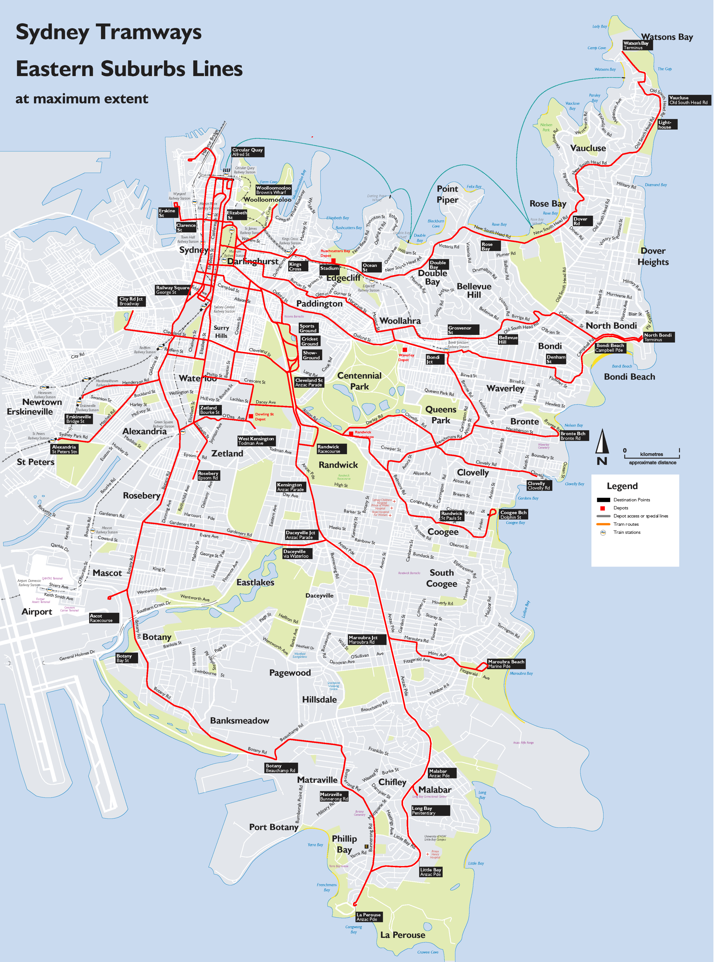
Well Bondi Beach is a prime example. The trams that famously "shot through" to Bondi terminated at North Bondi where Military Road meets Campbell Parade (AKA 'Scarborough Crescent'). The terminus can still be clearly seen, as can much of the route along Campbell Pde, although cars and buses have tended to take over the trampath for parking. Interestingly, bicycle races were also held on the Campbell Parade "hot-dog", before they too were driven out by the car traffic, firstly to road races along semi-deserted Bunnerong Road and finally into the fully-enclosed Heffron Park.

The tram route to Bondi is well documented with the most interesting deviation from the obvious being where the track took a graceful curve to the right (from Bondi Rd, heading down the hill) into Denham Street, then along Fletcher and onto reserved track just past Dudley Street. (The reserved track later became Rowland Ave.) The track crossed under Wilga Street in a cutting that continued on to also pass under Bondi Road, rejoining the main drag (southern end of Campbell Parade) on the other side of Bondi Road (at the Francis Street intersection). It's hard to imagine now, but yes there was a cutting and 2 overbridges involved in keeping the track at the desired gradient, all subsequently filled in. I witnessed the start of the filling-in in the mid 1970s.

or checkout my list of Sydney and surrounding airstrips and airports

Monday, May 18, 2009

Sydney's real infrastructure debacle... ditching the extensive tram network by 1961

Sydney has suffered many planning misfortunes and missteps, including the lack of a heavy rail connection to the northern beaches, despite long-standing plans to do so, and the seemingly endless indecision over the location of a "second" major airport (although some may argue that Bankstown airport already fills that role). My personal favourite though would have to be the dismantling of what was the 2nd-most extensive tram system in the British Commonwealth - second only to the London network and many times larger that Melbourne's. This startling removal of track, electric catenary and associated tram sheds was largely "achieved" by 1961. Tracks were ripped up or submerged under tar; tramcars were sold for scrap or burned; and land and buildings were reused as bus depots or sold.

Why oh why did we ditch light rail? Wikipedia says this: The overcrowded and heaving trams running at a high frequency, in competition with growing private motor car and bus use, created congestion. Competition from the private car, private bus operators and the perception of traffic congestion led to the gradual closure of lines from the 1940s.

Buses, you see, were more flexible in their routing and interfered less with other vehicular traffic. Which was good in theory, but the government-run bus routes largely replicated the tram routes anyway; and as both bus and car traffic grew the road network hit its natural limit as well - stopping everything in its peak-hour tracks.

Now this infrastructure planning miracle was achieved after seeking the input of overseas "experts" and largely executed by Labor governments. Interestingly, again quoting Wikipedia, closure was supported by the NRMA, but generally went against public opinion. Thank you once again, National Roads and Motoring Association. Nothing ever really changes, does it?

All that aside, some tantalising remnants of Sydney's trams exist, to remind us of our folly. For instance there are tramway remnants along Anzac Parade, through Randwick and Kensington, including reserved track and "bus stops" facing the "wrong way" (ie towards the trams, not the buses) towards La Perouse. There is a tram bridge at Annandale and sheds at Rozelle, Tempe and Newtown, plus recycled tram depots like Randwick bus workshops and a shopping centre at North Sydney. And plenty more, if you look closely enough.