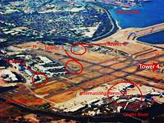
I'm not sure where Tower number 1 was, but I guess it was fairly close to Tower 2. Tower 2 became quite substantial over time and morphed into the TAA and East West Airlines terminal by the 1970s. It's still there, embedded into the Qantas domestic terminal.
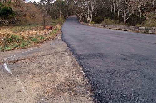
Tower 3 is also still there, near the intersection of 16/34 and 07/25, and is a fire station.
Tower 4 is still there, near the (relocated) Cooks River mouth.
And Tower 5 is the active current tower.
Saturday, November 15, 2008
Friday, November 14, 2008
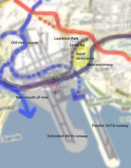
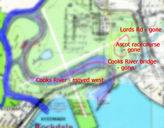
Sydney Airport - Part 6 - Cooks River 2008 vs 1940
History of Sydney Airport in pictures, number 6 in the series. This overview shows the lot. We have the old river course (dotted blue) and the new (solid blue). The original railway is dotted orange and the deviated line is solid. The original Cooks River bridge and associated roadway to Kyeemagh (including Lord's Rd) is dotted purple, the current motorway solid. Ascot Racecourse is in yellow. You can see all of the current runways and how they are placed against these changes.
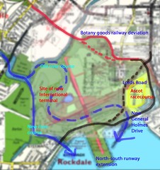
Sydney Airport - Part 5 - Cooks River 1966 vs 1940
History of Sydney Airport in pictures, number 5 in the series. In this overview of changes apparent between 1940 and 1966 we see the Botany Goods Railway deviation (red line, original route dotted) and the Cooks River in its original course (dotted blue) and altered course (solid blue). Ascot racecourse is shown in yellow but was of course closed and overlaid in the mid-50s by the 07/25 runway, shown here faintly in pink.
Also shown in pink is the slightly-extended 16/34 runway, yet to be taken fully out into the bay. That extension as shown caused General Holmes Drive to be laid into a cutting where it went under the runway. General Holmes Drive (in solid black) replaced the Lords Road/Government Rd combination (dotted black) that was also cut in the mid-50s by the east-west runway.
The International or Overseas terminal was still sited at Lauriston Park, near the TAA terminal (later to become Australian Airlines and then Qantas domestic).
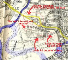
Sydney Airport - part 3- 1954 vs 1965
History of Sydney Airport in pictures, number 3. Some detail that appears when you compare a 1954 map with a '65 one. You can see that the new runways - short 16/34 and main 07/25 are in place and the remaining roadways renamed. There's a tram balloon loop on Lords Road in 1954 that used to serve the Ascot racecourse. The railway has deviated to the north, leaving room for Qantas to expand.
Sydney Airport - Part 4 - 1966 vs 1940
History of Sydney Airport in pictures, number 4. Big changes. Cooks River was shifted west, with the roadway to Kyeemagh largely removed or relocated. Polo and cricket grounds and the golf links to the west and south were also removed or relocated. Ascot Racecourse was absorbed.
Sydney Airport - part 2 - 1940 vs 1954
My potted history of Sydney Airport in pictures, part 2. Comparing and contrasting street directories by Premier, Robinson and Gregory's, here we are looking at what happened between 1940 and 1954. Please forgive me if you disagree, oh map-makers and publishers, but I think this is "fair use" - or re-use - of your art.
Starting from the north, Ricketty Street bridge is just such a great name that I have to include it. It spans one of only 3 industrial canals in Australia, and is still worth a visit today.
The original goods railway line is shown in yellow, with the northward diversion in pink and orange. I have shown where the suburb of Lauriston Park was, and Ascot racecourse in relation to the concrete (main) east-west runway (in pink) that was laid by 1954. To build that and the new but then-shorter north-south runway involved diverting and filling the course of the Cooks River (in blue). That was quite a project. Imagine trying to move a river now - you'd need to be pretty sure about how the changes would impact the local ecology, for starters.
Anyway, the Bonnie Doon Golf links in the north-west corner were replaced with what later became the International terminal and the cargo precinct. More recreation grounds were lost - a polo field, a cricket ground and another golf links to the south. And the main runway now ended where Ascot racecourse was in 1940. Muddy creek was also shortened in the whole process of moving the Cooks River.
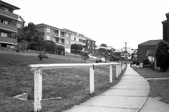
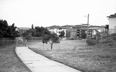
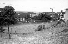
The dotted black line shows the new General Holmes Drive, replacing the old road, the bridge and Government Rd, all marked in brown. Some residences were left stranded by these changes, particularly those near the southern end of the short 16/34 runway. These houses were "on" General Holmes Drive until the mid-1960s, when the road was diverted into a cutting to the south and bridged-over with the extended north/south runway.

Starting from the north, Ricketty Street bridge is just such a great name that I have to include it. It spans one of only 3 industrial canals in Australia, and is still worth a visit today.
The original goods railway line is shown in yellow, with the northward diversion in pink and orange. I have shown where the suburb of Lauriston Park was, and Ascot racecourse in relation to the concrete (main) east-west runway (in pink) that was laid by 1954. To build that and the new but then-shorter north-south runway involved diverting and filling the course of the Cooks River (in blue). That was quite a project. Imagine trying to move a river now - you'd need to be pretty sure about how the changes would impact the local ecology, for starters.
Anyway, the Bonnie Doon Golf links in the north-west corner were replaced with what later became the International terminal and the cargo precinct. More recreation grounds were lost - a polo field, a cricket ground and another golf links to the south. And the main runway now ended where Ascot racecourse was in 1940. Muddy creek was also shortened in the whole process of moving the Cooks River.
The dotted black line shows the new General Holmes Drive, replacing the old road, the bridge and Government Rd, all marked in brown. Some residences were left stranded by these changes, particularly those near the southern end of the short 16/34 runway. These houses were "on" General Holmes Drive until the mid-1960s, when the road was diverted into a cutting to the south and bridged-over with the extended north/south runway.
Sydney Airport - part 1 - 1926 vs 1940
I think it's extraordinary what we did to create Sydney Airport at Mascot and it's worth revisiting the story occasionally to remind ourselves of both what we have created and what we have lost.
Thus begins my potted history of Sydney Airport, in pictures. It really started in the early 1920s with Nigel Love leasing land from the Ascot Racecourse and Recreation club, to the west of the racecourse, immediately west of the suburb of Lauriston Park, shaded green here. It was flat but boggy ground, bordered by Shea's Creek to the west and Cook's River to the south.
I have shaded the Ascot track in blue. It's shown on both the 1926 and 1940 Premier and Robinson street directories, but disappears by the 1950s. That racecourse area became, variously, vacant land to the east of the threshold of runway 07/25; the Flight Facilities or GA area to the northeast; the east-west runway threshold itself; and what is now long-term parking. You can see that Lord's Rd and the Cooks River bridge (in yellow) were still around in 1940, but disappeared when the river was diverted and the new concrete runways built (in the mid-1950s).
To the north is the Botany Goods Railway. You can see it is a straight line here, both in 1926 and 1940, but was later diverted to the north. Grass and gravel runways pointed roughly north-east to the south-west, and east-west during this period. The northeast threshold was cut by the railway line and one incident occurred when a DC3 collided famously with a goods train!
The streets to the north were subsumed into the airport after the railway diversion, later becoming part of what Qantas called its "Jet Base" with the advent of the 707. To the south are recreation grounds.
Thursday, September 11, 2008
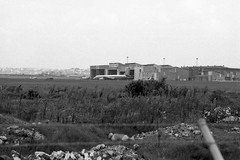
Sydney AP Tower c1930s
Sydney Airport goes back a long way, like aviation in Australia in general. Whilst early aviators tended to fly out of Penrith, Parramatta or Richmond (Clarendon) at first, a site closer to Sydney itself was selected near the Ascot race course, on flat marshland adjoining the Cooks River. To the east was extensive swampland and a mill, to the north was a brickworks. To the west was market gardens. To the south was the river, more swamp and Botany Bay, of course.
I'm unsure exactly when this tower was built but sometime in the 1930s would be close.

I'm unsure exactly when this tower was built but sometime in the 1930s would be close.
Friday, July 25, 2008
The ramp from bridge to tunnel

The Sydney Harbour bridge carries train (and bicycle) traffic on its western side. This is a shot of a mixed suburban electric set on the ramp from bridge to tunnel, just short of the tunnel itself. Next stop Wynyard station.
What is less well known is that the eastern side was designed for the same purpose, but for a heavy rail line that was never built. The line would have gone from Wynyard to the northern beaches, however the tide of public opinion (or perhaps political will) turned against infrastructure investment and plans for the line were filed away. However a somewhat less costly option was taken up: trams. As Sydney had an extensive tramway network on both sides of the harbour, it made sense to connect the 2 'halves' as it were and thereby avoid avoid maintenance facility duplication, tram/rail interchanges or even truck transport, whilst also providing a service to commuters.
Of course this impacted ferry use, but not as much as a heavy rail line would have. Manly's tram network was an isolated one, cut at the Spit, so whilst some commuters would not mind a short (mostly covered) walk over the Spit bridge, many more would still choose the ferry.
So the compromise bought a cheaper but less useful light-rail line but at the price of a 'proper' straight-through heavy rail line. A compromise that may still have paid dividends today, except we tore up the tram system by 1961. Which leaves us with buses and extra roadlanes on the bridge.
The tramline (whilst it lasted) paralleled the rail in many ways, with a tunnel to platforms at Wynyard (now deserted and partially used as car parking), a station at the Milson's Point side and a flyover bridge to North Sydney. The approach to that bridge is used (again) as car parking .
Thursday, July 24, 2008
Honey, I've shrunk the tram network

Oops. We lost a few lines between 1921 and 1950. Still, it's better than what we ended up with after 1961 - ie nothing. (Nothing but buses, anyway.)
So what disappeared? The Manly line went. Narrabeen went as well. Parramatta to Rosehill and Parramatta to Castle Hill, gone. Sutherland to Cronulla, gone. Kogarah to Sans Souci, gone. Rockdale to Brighton, gone.
And then in 1961 we pulled the plug on the whole Sydney system.
Whilst we may blame our current governments for lack of investment in public infrastructure we must remember that this "trend" really dates back some 50 years or more. And it's hard to turn these things around.
So how did it happen? After the mad rush to build infrastucture and create a backbone for Sydney's development a few sums were quietly done. Whilst many tram lines were opened to win political favour as well as to profit developers, the actual patronage revealed was quite poor on the outer lines, whilst costs were absurdly high. These outer suburban lines were also isolated from the main network or were using outdated technology. So the low-hanging fruit (as we say) was plucked - the worst returns in the least politically sensitive areas went first. Light and heavy rail plans were quietly scrapped (like heavy rail to the northern beaches), scaled back or slowed down (like the eastern suburbs railway) and investment switched to cheaper, more flexible but oil-dependent buses instead.
Of course buses use roads, and cars also need roads. So it all seemed to make sense in a world of cheap oil and post-war wealth. People liked cars after all. And it benefited the increasingly important - and powerful - automobile industry. It seems amazing that the trams stopped less than 50 years ago - and that here we are now facing a growing shortage of public transport infrastructure, in a world where trams could have played a wonderfully effective role.
Rally cars on roof of Bankstown Square shopping centre
In the '70s we could even start car rallies from the roof of a major suburban shopping centre. Imagine that.
Did you say 'trams'? Have a look at this...

You wanna see a tram network? THIS is a tram network... alas it's all gone, bar one newish and oh-so-short light rail system that runs briefly over some of the same territory.
Wednesday, July 23, 2008
Sydney's airports, aerodromes and airstrips
It's list time again! (Updated several times now, including fresh links. Note also multiple posts on some of these airfields. Use Ctrl-F to search the list.)
Apologies for the broken links. My domain name was 'pinched' when I wasn't looking! Please use the search box until I fix it (sadly it will take a long time).
There is also an excellent heritage study available from NSW Environment and Heritage on the subject of "World War II Aerodromes and Associated Structures in NSW". It's well worth a look.
Apologies for the broken links. My domain name was 'pinched' when I wasn't looking! Please use the search box until I fix it (sadly it will take a long time).
- Sydney Airport, established circa 1920 on land leased from the nearby Ascot Pony Racing club (the north-eastern corner of the airport, more recently known for general aviation and "flight facilities" use). Access via tram to the Ascot race course, and by road from Botany Road. Initially just a relatively flat paddock of grass and sand. Gravel runways added from 1932, first such strip 450 metres long. 2 additional gravel strips added by 1938. Freight railway in north diverted after accident between train and DC3. Cooks River and Alexandria canal diverted and new, concrete runways aligned 07/25 (main) and a shorter 16/34 constructed by 1954. The latter extended into Botany Bay from 1969, with a parallel strip added in late 1990s
- Rose Bay, the flying boat base from 1938 and chief international airport until circa 1950. Closed in 1974. Seaplanes still fly from several locations in the Sydney area including Rose Bay.
- Bankstown Airport, now only 4th busiest by movements in Australia, apparently. Used to be number 1. Multi-runway parallel strips, some crossing (but disused). Bankstown has three main parallel east-west runways, a long centre runway for high-performance aircraft, a northern runway for arrivals and departures, and a southern runway for circuit training. Originally planned in 1929, not established until 1940 as an RAAF facility. Subsequently taken over by the USAAF and established as a key strategic air base to support the war effort, circa 1942. It transferred from US to British Fleet Air Arm operations in 1945, and was known as Royal Naval Air Station Bankstown, or HMS Nabberley, until handed back to the RAAF in 1946. Interestingly, several "dummy houses" were built to make Bankstown Airport appear as a farm, with disguised hangers and fake roads. There was an underground command post on Black Charlie's Hill with gun pits located within and around the airport to protect it from air attack. Another anti-aircraft battery was situated on high land on the corner of Bexley Road and Homer Street, Clemton Park. De Havilland and successors have been located at this airport since 1942, occupying the area south of the main runway. RAAF Mosquito bombers were built there. The primary (centre) runway (11C/29C) is 1,415m x 30m, limited to 50 tonnes MTOW. Marshall Airways and Sid Marshall's museum was based here, too. I undertook flying training here at Illawarra Airways, so it's of some personal interest!
- Hargrave Park, Liverpool, an historic airfield (circa 1920s) now part of the residential suburb of Warwick Farm. Closed circa 1945. Was used for public housing thereafter with complaints about squalor.
- Camden, ex-WWII RAAF Kittyhawk base in current civilian use. AKA 'Macquarie Grove', initial development was private and the airfield was 'loaned' to the government, a deal which became permanent after the war. RAAF Camden housed squadrons 15, 32 (Hudsons, Beauforts) and 78 (Kitthawk). Camden was also the first RAAF Central Flying School (CFS), before being moved to RAAF Tamworth. I flew light training aircraft into Camden in the mid 1970s and can attest to "Kittyhawk-sized" ruts in the grass/gravel taxiways then in use
- Richmond, current RAAF base, has been so since c.1937. Supplemental airport for Sydney from circa 1914, perhaps 1912. Home base for Sir Charles Kingsford Smith and Charles Ulm and their Fokker Trimotor 'Southern Cross' during the late 1920s. Possibly (one account) originally called...
- Clarendon (see Richmond), as per the nearby railway station (railway now ends at Richmond but used to cross the Hawkesbury/Nepean and climb to Kurrajong) was the original airfield (perhaps slightly south of current site) and pre-dates Sydney Airport. This area and Richmond also known as Ham Common. William Ewart Hart attempted to start a flying school from this site, circa 1912, as well as his Penrith site at...
- Belmore Park, an historic airfield circa 1911 or earlier in Penrith (now a housing development). Was used as a base by William Ewart Hart for flights such as his 1911 journey from Penrith to Parramatta and return, and as a training site. First recorded aircraft crash in Australia was by art and passenger, near Rooty Hill/Seven Hills. Also site of Penrith Speedway and historic Thornton Hall. North of railway. See also Jamison Park, south of railway
- Parramatta - actual site of Hart's first and subsequent landings uncertain to me but probably within what is now Parramatta Park
- Menangle, 'dispersal' airstrip, a WWII runway built circa 1942 in case of Japanese attack on Sydney. Basically aircraft would fly to these dispersed sites and hide in the forest. Later used as an overflow for Schofields
- Bargo 'dispersal' airstrip, another WWII runway, as per Menangle
- Cordeaux 'dispersal' airstrip, another WWII runway, as per Menangle
- The Oaks 'dispersal' airstrip, another WWII runway, as per Menangle and others. The Oaks airfield was constructed circa 1942 as a satellite aerodrome to RAAF Camden. There was a 5000 foot x 150 foot sealed runway aligned 36/18 and split by Burragorang Road (complete with gates to stop stray cars!). Operations probably included Hudsons, B24 Liberator bombers and Kittyhawks. Not required post-war by the RAAF, it was offered for sale in 1946. The current strip is a private field, roughly the southern half of the wartime area. The original runway was removed but a 950m 18/36 main grass strip (perhaps wartime taxiway) was left and a new grass strip of just 400m added (aligned 09/27)
- Ettalong/Woy Woy 'dispersal' airstrip, another WWII runway, as per Menangle. Believed to have been largely converted into a residential street running north/south
- Marsden Park airstrip, a WWII runway and later motorsport venue. There's an interesting link between this airstrip and Australian F1 motorsport engineer Ron Tauranac, too
- Pitt Town 'dispersal' airstrip, a WWII runway and later motorsport venue
- Schofields aerodrome, a WWII RAAF base and Royal Navy Pacific operation for a few years thereafter; 3 intersecting runways; a motorsport venue 1950-59 (possibly conflicts with the RAN records of operation there in 1953); a Naval base (HMAS Nirimba) from 1959-circa 1974. Closed since 1994, although operations were reported up to 1998. Now a housing and educational site, with aerodrome land, including a 'blimp hangar' and remaining portions of runway) on sale from 2008
- Mt Druitt airstrip, 690 acres in area, circa 1942-1951; a WWII runway approx 1520m long, 2 hangars; later a motorsport venue (1950-53?). The race track was 3.6 kms long and situated on what is now Whalan Reserve, the Mt Druitt Industrial Area and Madang Avenue Primary School.
- Holsworthy airstrip, a current Army airstrip dating to WWII. (AKA Luscombe airfield). Main strip for army in Sydney, plus 2 smaller strips due South...called...
- 'Mackel' and
- 'Complete'
- Hoxton Park airstrip, Cowpastures Road, 1098m long, oriented 16/34. Closed, redeveloped. A WWII 'dispersal strip' runway (in case of Japanese attack) Hoxton closed circa 2008. It did retain features from the war, including gravelled aircraft hide-outs and wartime drainage, taxiways and markings. At the northern end of the runway could be seen 2 earlier forms of surface, one bitumen and the other gravel, and wartime drainage works were found under the runway. There wass also a wartime taxiway leading off to the north-west, beyond what was the airport perimeter and evidence of aircraft 'hideouts' in the neighbouring eucalyptus forest. There were 2 surviving taxiway bridges across gullies or drainage lines prior to redevelopment. There was further evidence of taxiways and hideouts to the east of the current runway. The original airstrip was 5000ft (1524m) long and 172ft (52m) wide. The runway has been shortened since World War II and the former runway extension is noticeable at the northern end of the runway. The aircraft revetments or hideaways to the west of the aerodrome may have been removed or destroyed during the construction of the M7 motorway and building of a large suupermarket distribution centre.
- Warnervale aerodrome, about 100km north of Sydney, which is my local strip. It's big enough for a DC-3 but is increasingly hemmed in by development. There are "plans" for a new strip in the region.
- Katoomba airstrip, about 100km west of Sydney (closed in 2016)
- Wedderburn airstrip, southwest of Sydney. Active. Single runway. Increased growth since closure of Hoxton Park.
- Albion Park aerodrome, about 100km south of Sydney
- Bringelly emergency WWII strip, Not exactly sure where that one was...
- Fleurs WWII strip and previous CSIRO radiophysics site.
- Calwalla WWII strip in the southern highlands
- Nepean Dam airstrip... or was it? It may have been an EAA, an emergency alighting area for seaplanes rather than an "airstrip". See also Cordeaux Dam dispersal strip and another possible alighting area on the Nepean River near the Jamison Park airfield
- Ravenswood airstrip - a WWII dispersal strip attached to Fleurs but apparently not proceeded with...
- Wallgrove Aerodrome - built in 1942, the runway was 5000ft (1524m) long and 50ft (15.24m) wide, running roughly NW-SE. Wallgrove closed in 1946 and reverted back to farmland (historic "Bungarribee"). A number of former hideouts or aircraft revetments are still visible, as is most of the runway. However an industrial area has been built over what was the southern end of the airstrip. AKA "Doonside" airfield
- Badgery's Creek - or Kemps Creek or possibly RAAF Fleurs - west of Liverpool, a planner's dream for the last 30 years - or is it?
- Somersby - Lackersteen's Road - a private strip near Gosford on the Central Coast
- Cooranbong - now sadly closed, formerly an extensive flying school base south west of Newcastle
- Wamberal - another Central Coast airstrip that's been mentioned but I've never actually confirmed where exactly it was... on the beach? Or on the ridge above the beach?
- The Entrance/Bateau Bay - an airstrip that became a high school (Central Coast, again)
- RAAF Base Rathmines - although not an airstrip of course is also worth noting (Lake Macquarie, south and south west of Newcastle). Think flying boats, Catalinas, that sort of thing!
- Tuggerah - another Central Coast airstrip of wartime vintage, east of the railway, south of the lake.
- Wallacia - west of Sydney. Single strip near Bullen's Animal World. Both no longer operational!
- Wilton - existing field south west of Sydney, used for skydiving. WWII dispersal airstrip. 3 triangulated runways
- Centennial Park - at least one early flight in and out
- Ascot Racecourse - Maurice Guillaux flew demonstrations there in 1914 and crashed badly. He recovered and flew from Ham Common, or Richmond if you prefer (go up the list!)
- Jamison Park, Penrith - from perhaps 1930s into the 1950s the home of Penrith Aero Club. Worth noting the discussion (with Russ Adams) in the comments below about a possible adjacent emergency alighting area (EAA) for seaplanes on the Nepean River. Alternatively this EAA was located at the relatively remote Nepean Dam, part of Sydney's water supply history. It may be that this EAA replaces number 30 on the list, "Nepean Dam airstrip". See also Cordeaux Dam airstrip (number 12 on this list, a confirmed dispersal landing ground)
- Victoria Park racecourse - another creative use of a horse racing track by early aviators
- Llandilo - may have been a dispersal airstrip or simply another name for Marsden Park. Was/is certainly a DCA HF Transmitter site
- Londonderry - the RAAF's HF Transmission site. Castlereagh was probably the nearest dispersal strip
- Castlereagh - dispersal airstrip and dragway
- Erskine Park Quarry airstrip
- Kennett's Field, or Luddenham airstrip
- Wyong Airstrip - as reported by Chromedoctor in comments below: "1970-1990 originally a 2'000 strip but direction was changed and a 3'000 strip was made This airstrip was made on an original landing site used by Reg Ansett c1936.. the airstrip was closed due to contaminated ground from chemical fire rendering more development unviable...Site is now Mercure Kooindah Waters Resort.." See also Tuggerah and Warnervale above.
- Asquith or Mount Colah airstrip. Described as gravel, and being located on part of Asquith Golf course, and cut by the F3 roadworks in the 1980s. No other details, I'm afraid.
- Hat Hill Rd airstrip, Blackheath. Closed in 1955
- Kulnura airfield. Or is it Mangrove?
- I'm sure there are more!
There is also an excellent heritage study available from NSW Environment and Heritage on the subject of "World War II Aerodromes and Associated Structures in NSW". It's well worth a look.
My list of Sydney's race tracks and circuits.
or checkout my list of Sydney and surrounding airstrips and airports. Interesting recreation of Amaroo Park
Did you blink and miss racing at Amaroo? I was lucky enough to drive the track a few times and can confirm that this is an awesome recreation.. just add terror as you crest the hill at around 160kmh (in a road car) approaching the Loop... ever so slightly sideways.
Catalina Park in use - 2000 - lap dash
Obviously the track was intact in 2000... eight years later and there are significant washaways and overgrown sections. Frankly I wouldn't want to run a lapdash on such a narrow circuit with so few run-off options...
Catalina Park Rallycross Track in the '70's... and now
Interesting set of stills showing Catalina then and now...
Monday, July 21, 2008
Sydney's race tracks - bikes, cars - even horses
Generalisations are a funny thing, and here are 4: humans are (a) attracted by and somewhat fond of following tracks and paths; (b) competitive critters who like playing "chasings"; (c) social animals that like to gather in mobs around a focal point; and (d) quite happy to sit in those "mobs" just watching other humans playing chasings, often for hours at a time.
I could also add 2 geeky addenda, that (a) humans like to document what the other humans are doing, even if they don't do it themselves; and (b) humans like lists of stuff.
Do you see where this is heading?
Now I'll miss a few I'm sure, but for the record here's my take on a list of Sydney's race tracks, especially focused on those that hosted documented races of the wheeled variety but also ponies and horses, greyhounds or whatever springs to mind... in no particular order! (Use Ctrl-F to find or just read the lot.)
- Sydney Sports ground - pushbikes (ie real bikes) raced here on a large, shallowly banked outdoor velodrome until about WW2; also speedway cars and motorbikes after that date (until noise complaints outnumbered followers of the sport, who moved west to...
- Liverpool Speedway - from 1967 to 1989, a banked dolomite surface; pretty much a short dirt oval track for car and motorbike racing, out Casula way
- Liverpool 'Collingwood' racecourse - circa 1832 the 'Sydney Turf Club' (not the STC formed in 1943 then!) opened a course near Liverpool, probably the one referred to elsewhere as the Collingwood racecourse, used until 1900
- Liverpool Woodlands racecourse - circa 1890s the Liverpool Turf Club had been formed and was holding races at a course near O'Brien Parade off Orange Grove Road. By 1892 this venture was known as the Liverpool Horse and Galloway Racing Club
- Centennial Park - a great training Mecca for cyclists, used for road cycle racing on a variety of circuits over the years, it featured also in the 2000 Olympics with both road cycling and the individual road time trial. It was also briefly a landing ground for early aircraft
- Parramatta Park, another excellent road course for cycle racing, was also used for car racing in the 1950s, until common sense presumably prevailed. Another park used as a landing ground by early aviators. Was also the place to see preserved steam trams for a while, now you have to go to Valley Heights
- Henson Park, Marrickville - an old quarry converted into a large outdoor velodrome around 1930, regularly hosting 30,000 spectators on a Saturday night. Replaced in the early 1970s with a steeply-sided (45 degree, 250m) concrete velodrome at...
- Camperdown, built in or around 1970 in an old quarry/tip, now residential, semi-replaced (how could it truly be replaced?) by...
- Tempe Velodrome, a 330m concrete track for track racing, built around 1983 in twinship with the Chandler velodrome in Brisbane to replace...
- Wiley Park, a decent sort of banked bike track that fell victim to road widening (King George's Rd) in the early 1980s. Remnant banking still exists. But all of these velodromes are overshadowed by the...
- Dunc Gray Olympic Indoor Velodrome, Bass Hill, a timber track purpose built for the 2000 Olympics
- Complete with a criterium track next door, added post-Olympics. Just a shame it's in Bass Hill (no offence meant, it's just plain hard to get a crowd there)
- Not too far away is Hurstville Oval, a well-maintained saucer-type velodrome for track-bike racing that quaintly encircles a cricket pitch
- Several criterium tracks also exist in Hurstville, notably one around Oatley Park (used by St George club for many years)
- and the purpose-built cycling tracks in Kempt Field
- and Olds Park, both used for the sadly-defunct Commonwealth Bank Cycle Classic
- Not far away from Hurstville is another purpose-built criterium track for bike racing at Waratah Park, Sutherland, used by the Sutherland Cycling Club. Watch out for the big dipper on the long circuit, it's a hairy turn at the bottom
- And yet another excellent crit track exists at Lansdowne Park, near Bankstown, a fast and twisty track with a steepish rise to the downhill finish
- Merrylands Oval, a slightly-less-picturesque but functional saucer velodrome that was home for the McGee brothers for many years
- Lidcombe Oval, even-less-picturesque saucer velodrome with a sharper than expected left turn after the finish. Or was that before the finish? It catches you out, anyway!
- Blacktown Oval - a crit course for bicycle racing with a big tree to dodge on the left and a short and hard-braking area immediately after the sprint. If you don't brake hard you end up in the street...
- Bondi promenade, yes that Bondi, was used as a bicycle racing venue (from the 1940s, or earlier?) until increasing traffic pushed the racing out to Bunnerong Road in the 1960s, until finally a dedicated circuit was built in the 1970s at...
- Heffron Park, Maroubra. An old military base complete with Nissen huts/Bellman hangars and long strips of hardstanding concrete (said to be for tanks), Heffron is spiritual home to the Randwick Botany and Eastern Suburbs Cycling Clubs
- There's also an Olympic rowing course at Penrith with an access road that's now used for road cycling and time trials
- Penrith's other speedway, Brooklands
- And an Olympic Mountain bike course at Fairfield
- And Penrith Paceway, harness racing at Penrith Showground
- And Penrith's late 19th century racecourse at Jamison Park (later an airstrip)
- Moving back east, there's Randwick racecourse - horses, rock bands and more recently the Pope (who obviously doesn't mind the horse racing and betting connection). Noteworthy for the massive multi-platform tram station (now sadly a car park)
- Victoria Park, Zetland - ponies, probably cars as well. Then it became a Nuffield (later Leyland) car factory, Naval stores and finally a residential development
- Ascot - at Mascot. In the far northeastern corner of today's Sydney Airport it was a pony race track with tram access (a balloon loop). Not much remains to be seen
- Warwick Farm - horses (still) and previously cars (until maybe the late 70s? I did a driver training course there in about 1978 on just a segment of the track - 'Creek Corner' - it was seriously narrow with plenty of trees and the aforementioned creek to miss - or hit!). William Long circa early 1880s bought J.H Stroud's 'Warwick park' grant north and east of Liverpool and by 1884 had also developed his property across the river, building stables and tracks there. He called this estate 'Chipping Norton'. In 1922 the racecourse was sold to the Australian Jockey Club (AJC) and in 1923 it was closed for redevelopment. The new Warwick Farm course opened 2 years later. A spur line off the main rail line led directly to the racecourse, being subsequently electrified in 1929. Used for military purposes in WWII, Hargrave Park airfield was nearby, to the west
- Campbellfield estate, Campbelltown, along Bow Bowing Creek; circa 1840s. The Campbelltown Turf Club leased 60 acres (24ha) from a John Keighran for a racecourse
- Narellan - a racecourse was built at Studley Park, Narellan and meetings were regularly held there in the 1890s. Accessible by train to Campbelltown and then by steam tram to Narellan (a long closed line, however embankments remain)
- Menangle Park - south of Campbelltown, a horse racing track in use since the 1870s. Railway sidings were built to bring people to the track. It was a WWII RAAF dispersal airstrip, too
- Rosehill racecourse, near Parramatta - horse racing, interesting for its access via a wharf on the Parramatta River and a steam tram from there to Parramatta itself. The steam trams also ran from Parramatta up to Castle Hill. The first race meeting in Parramatta was held in 1810. In 1885 Rosehill Racecourse itself was built on what had been John Macarthur's estate
- Rosebery - just off Gardeners Road,bordered by Florence Ave, a pony training track. Not much left, it became housing in the 1960s. Plenty of sand hills and lakes in this area, and the trams went right past. In fact the tramways used an area nearby to source sand and gravel for track laying
- Kensington - right next door to Randwick on High Street, just off Anzac Parade with plentiful tram access; now part of the Uinversity of NSW. At least one old building is still standing and was used to house 'the Old Tote' theatre company for a while, and NIDA
- Kogarah - pony track, corner of President Ave and Princes Highway, now a TAFE College; served by steam tram of course. AKA Moorefield.
- Sydney Sports Arena, Surry Hills - a steeply-sided wooden velodrome in the area of Devonshire Street (a mural exists depicting this, off Elizabeth Street). Moved to Canterbury
- Canterbury racecourse - still a horse racing track, the south-eastern corner housed the old indoor timber Sydney Sports Arena velodrome for bike races (which was moved holus-bolus from Surry Hills in the 1950s). Watch the splinters!
- Maroubra - the Olympia motor racing oval - in the general area of Mons Ave, served by trams. Site was chosen for its remoteness, in the sandhills overlooking the beach and was sadly quite deadly with the occasional car flung out of the track, launched into mid air...
- Belmore Park, Penrith - Circa 1920s Belmore Park was used as the Penrith Speedway, a dirt track, one mile in circumference. Car, motor cycle and aircraft races were held. Belmore Park was also used for aviation circa 1911 onwards
- Marsden Park - a disused WWII airstrip put to good if brief use as a car racing facility in the early 50s
- Pitt Town, near Windsor - another old WWII airstrip put to limited use for motor racing in the 50s, up to early 70s perhaps later. Also part used as Hardie Ferodo vehicle braking test track
- Schofields, near Blacktown - a disused RAAF aerodrome (3 intersecting runways!) that was used for motor sport from about 1950 until '59, when the airstrip was reactivated as a Naval Air Station. Being so close to Richmond RAAF base was a problem (as a trainee pilot I did touch-and-goes here in the early/mid 70s - it was v. easy to stray into the RAAF prohibited zone and get a verbal caning!). The aerodrome was deactivated once more in the late 1970s with a fence put across the main runway, stranding a DC-3 in situ. Sadly now used for housing... (the land, not the DC-3)
- and Mt Druitt - yet another old airstrip converted and connected to access roads to form a makeshift (and potholed) racetrack for cars and motor bikes. Closed in the late 50s, it got more use than other disused airfields - but now gone
- Castlereagh - another airstrip converted to Sydney's premier dragstrip and closed with the advent of Eastern Creek
- Catalina Park, complete with PBY-5A Catalina Flying boat in a lake, was a car racing circuit at Katoomba, 100km west of Sydney during the 1960s. It got a reprieve via Rallycross in the 70s and continued with occasional car club use (lap dashes mostly) until "final" closure in the 90s due to growing noise complaints and the fact that it is an incompatible use (being in a national park and draining into Sydney's water supply as it does). It still exists however and is mostly complete - but the Catalina itself is long gone
- Amaroo Park, Annangrove: a twisty, hilly car racing circuit opened in the 60s, closed in the 90s. Noise problems again. Now housing
- Oran Park, Narellan: a combination of 2 tracks (north and south) that could be combined to form a single, scary-fast "GP" circuit. Closed circa 2008 and is becoming (yawn) more housing
- Eastern Creek, a "newish" track in western Sydney that comprises a car circuit and a dragstrip. The circuit itself and connecting roads and car parks are also used for bicycle racing
- Moving back towards the coast, there are 2 historically interesting venues - firstly Wentworth Park, Ultimo, a multisport park complete with a railway viaduct through the middle. Greyhounds, trotting, pacers - I have no idea really. Something to do with horses and dogs, I believe, with bets placed
- And Harold Park at Glebe with much the same mix of animals raced around an oval of sorts nestled up against the old Rozelle Tram depot. There must be a good reason to house seemingly similar venues so close together but I haven't explored why it is so... yet
- Luddenham - a suburb with an airstrip, a new motor racing circuit and a quarter-scale speedway, as well as the base for a society of model engineers!
- Kulnura, a private loop of a road, purpose built to exercise supercars and the like
- And Pratten Park at Ashfield with a rich history of mixed sporting facilities was once home to a wooden velodrome (in the 1930s). More details may be found here
- I'm sure I've missed a few... please insert them here!
My list of Sydney's race tracks and circuits.
or checkout my list of Sydney and surrounding airstrips and airports. Steam at Clarence Station, Zig Zag
The Great Zig Zag, indeed.
It's a bit out of Sydney but hey, this is part of Sydney's history too. There was a zig-zag section on both sides of the Blue Mountains in the 19th Century. Whilst this was slow - it required engines to stop, decouple and 'run around' to drive the train up or down the next section, it was cheaper and easier to build at the time.
There was also a zig-zag railway at Thornleigh in Sydney that went from the station area down to a mine.
Old and new lines detail shot
A close up. You can also see the mining railway to Newnes on this map.

Lithgow Zig Zag: old and new lines compared
It's a bit out of Sydney but hey, this is part of Sydney's history too. There was a zig-zag section on both sides of the Blue Mountains in the 19th Century. Whilst this was slow - it required engines to stop, decouple and 'run around' to drive the train up or down the next section, it was cheaper and easier to build at the time.
There was also a zig-zag railway at Thornleigh in Sydney that went from the station area down to a mine.
There was also a zig-zag railway at Thornleigh in Sydney that went from the station area down to a mine.
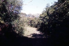
Catalina Park_0052
I love these old tracks... disused, derelict but full of memories. Alas this track was built over an aboriginal site of significance, and motor racing is not in keeping with the National Park ethos of the area. Check out the wooden guard rails...

Catalina Park Katoomba
Technically it's west of Sydney, but it's so close and so much a part of Sydney life that it gets a guernsey here.
Would you believe this was originallly a privately-funded amusement park with an ornamental (and actual bathing) lake? Later to include a Catalina flying boat (in the centre of the lake, hence the name) that was presumably trucked in?
Later still (around 1950) a motor racing circuit was built around the edge of what was known as "the Gully" north and west of this shot, to the dismay of residents, many indigenous. Thousands of years of aboriginal Australian culture was disturbed or destroyed in the process of creating a track for car racing. Great work, guys. Mind you, that was how things were done - with fewer regulations, less concern for the past (or for safety!) and a very different understanding of our shared history, development just "happened" and the consequences were dealt with much later. Sadly we all pay for this loss of history; even motor sport pays the price because they lose a track that, if better placed, could have remained viable.
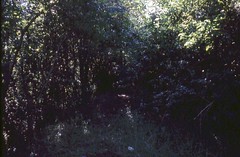
Mind you, if you take a walk around the old track you can't help but be amazed. It's still walkable, even rideable by bicycle. In many places it's walled by wooden safety railings with little or no safety run offs for cars.
It was still in occasional use when I was lap-dashing with a car club in the early '80s and whilst I didn't give it a go myself I can say that margin for error was close to zero. Brave. Dangerous. Exciting. Take your pick. The inner mudbath/dust bowl was also used for rally cross.
 A shale and coal railway line also passed on the western edge of the park, providing a link from the main railway on the plateau down to the mines in the beautiful, otherwise unspoilt valleys. That was the 19th century in action I guess.
More info and another pic here.
My list of tracks.
Would you believe this was originallly a privately-funded amusement park with an ornamental (and actual bathing) lake? Later to include a Catalina flying boat (in the centre of the lake, hence the name) that was presumably trucked in?
Later still (around 1950) a motor racing circuit was built around the edge of what was known as "the Gully" north and west of this shot, to the dismay of residents, many indigenous. Thousands of years of aboriginal Australian culture was disturbed or destroyed in the process of creating a track for car racing. Great work, guys. Mind you, that was how things were done - with fewer regulations, less concern for the past (or for safety!) and a very different understanding of our shared history, development just "happened" and the consequences were dealt with much later. Sadly we all pay for this loss of history; even motor sport pays the price because they lose a track that, if better placed, could have remained viable.
Mind you, if you take a walk around the old track you can't help but be amazed. It's still walkable, even rideable by bicycle. In many places it's walled by wooden safety railings with little or no safety run offs for cars.
It was still in occasional use when I was lap-dashing with a car club in the early '80s and whilst I didn't give it a go myself I can say that margin for error was close to zero. Brave. Dangerous. Exciting. Take your pick. The inner mudbath/dust bowl was also used for rally cross.
More info and another pic here.
My list of tracks.
Monday, June 16, 2008
QF DC4 1977
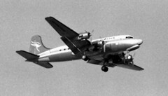
In 1977 there were 2 ways to get to Norflok Island - by sea, or by air. I guess little has changed in that regard, however the type of aircraft used certainly has changed. This is a Qantas DC-4. Yes, it really is the famous flying kangaroo adorning the tail of an elderly Douglas Commercial airliner, just one step up from the illustrious DC-3. And it's 1977. Why this blast-from-the-past? Because Qantas was obliged to provide a service to the remote Pacific Island (and Australian territory), it retained its fleet of DC-4s until the airstrip was upgraded and the work passed onto smaller but more modern aircraft. The DC-4s had the range and payload to do the job, plus the reliability and safety-over-water of 4 engines, as well as being surprsingly easy on the old grass field at Norfolk.
Tuesday, June 3, 2008
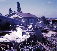
Convair 990 N8357C Sydney Airport
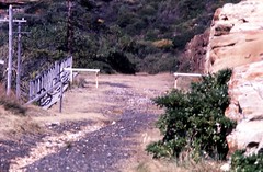
It's as close as I could get. The fence is the airport boundary, the rubble is probably just fill from anywhere. This part of the airport (essentially the eastern end, near the 07/25 runway) is just south of what was Ascot Racecourse, a pony racing track up until the 1930s. Behind me is the main airport access road from the east and south and the freight railway to Botany.
The hangars are for Ansett and TAA maintenance. The Convair was a visitor, parked in possibly the worst place for someone to get to, unless you simply walked through the hangars themselves (possible on the right day - it was 1976 after all. I think that's a CSIRO DC3 on the left.
The hangars are for Ansett and TAA maintenance. The Convair was a visitor, parked in possibly the worst place for someone to get to, unless you simply walked through the hangars themselves (possible on the right day - it was 1976 after all. I think that's a CSIRO DC3 on the left.
Sunday, June 1, 2008
Rose Bay flying boat base
Rose Bay flying boat base - Sydney's forgotten international - and domestic - airport. Convcniently located on Sydney Harbour!
I can remember visiting the base in the 60s and 70s, when Ansett ran 2 Short S25 Sandringhams (one a converted Sunderland) on trips to Lord Howe Island. Being young at the time and a bit short of cash I was hesitant to actually fly in the darn things (regrettably!) but I watched them land and take off and sitting beached on wheels outside the hangar. I should have at least gone on a charter to Lake Macquarie, to the old RAAF base Rathmines, but I didn't. Oh well. That's life I guess.
There's not much left to investigate at Rose Bay, sadly - but enough to get a feel for it. There's actually a lot more at Rathmines. Worth a visit!
And worth a read:
- Interesting and relevant site: http://www.airwaysmuseum.com/
- "Golden Age of Flying Boats"
- RAAF Rathmines - flying boats on Lake Macquarie
- One of my other Rose Bay posts
- Short Sandringham at Rose Bay
- Another Short Sandringham shot!
- Another post by me
- And my Flickr images of the Rose Bay site.
- Or here is an updated list of Sydney's airports.
Alexandra canal and Sydney Airport
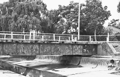
Alexandra Canal is a relic of our past that shouldn't be forgotten. Check this out for its immense detail: http://www.aussieheritage.com.au/listings/nsw/Sydney%20Airport/AlexandraCanal/2551Many's the time in my misbegotten youth I wandered along stretches of Alexandra Canal and wondered "why is it so?". I could see that it was meant to be an industrial canal, like you may find in Europe, but why did it so obviously fail to, umm, "take off"?
If you follow that link you'll get the full story. But here's my take on it... with my own recollections and observations thrown in. Yes, it is a relic of a 19th Century NSW Government initiative to create water transport, one of just 2 in that state and 3 total in Australia; and yes, it was based upon the English canal system. It partly used unemployed labour in its construction. The canal itself played its part in the draining and in-filling of large areas of low-lying in the Alexandria and Botany area, opening it up for development.
It's worth a look. Intact original sections of the "fascine-dyke sandstone construction" are apparently rare examples of late 19th century coastal engineering works. They certainly look it, too. My favourite views of this barely-navigable canal were from the Ricketty Street bridge (love that name) and along Airport Drive (where I spent many hours watching and photographing aircraft landing, of course). Some parts of the Cooks River are lined in the same way.
Alexandra Canal is also known as Shea`s Creek, a tributary of the Cooks River, and it begins in what were once the sandy hills of the present Surry Hills, north of Redfern. The sand hills themselves are long gone but stretched east to South Dowling Street (where Australian Glass Manufacturers set up a factory, strangely enough) and south to Botany and the marshes that surrounded northern Botany Bay. Dredging commenced in 1887 to adapt Shea`s Creek to a canal, starting with a junction with the Cooks River, south-west of the existing Sydenham-to-Botany railway bridge. It extended north only so far as the Canal Road Bridge - and had to be re-aligned somewhat as the airport expanded.
However plans were afoot to extend to Buckland Street, Redfern - which would have been interesting indeed, had it happened. Apparently that extension only got as far as Huntley Street, Alexandria (in about 1897) before political will died away. We all know what that's like.
Other interesting bits from that URL above:
Enough about the canal, what of the Airport? Again drawing heaving from that link, but with my observations added, the airport was significantly expanded from 1947. The airport land was expanded to include much of what had been Sydney's water supply reservation (near the old Mill Pond, ie the south-east corner of the field, now variously helicopter and car parking as well as roadway) as well as former Rockdale Sewage Farm land (near Muddy Creek), the F. T. Wimble and Co. Ltd Ink Factory (unsure where that was), the Mascot Granite Works (or that) and the whole of the suburb of Lauriston Park (which of course is pretty much the core street scape of the "domestic" terminal area - severed from surrounding suburbs by the Botany Goods railway line.
Much of the "new" east-west (07/25) runway was constructed along the centre of the existing Cooks River, requiring a major diversion. The diverted river was placed on the western boundary of the airport, with a hard turm to the south instead of a gentle meander across the airfield. Whereas it once flowed out to the Bay near the Mill Pond, it now exited next to what became the site of the 1970s Control Tower. Some houses in that area were also marooned when the river moved.
The excavated material and sand went to the aerodrome to raise the level of the runways and to fill the old Cooks River alignment. You can see a swampy area created by the removal of the river in maps and photos of the time, to the north of the intersection of the 2 main runways. Later, after the new runways were operating, the Alexandra Canal south of the railway bridge, including a surviving stretch of what was the Cooks River, were realigned, the original Canal and riverbed filled and a new channel cut through further to the west. This work created some more space for airport buildings to the north, including the international terminal, and was complete to my recollection by 1969. A new road bridge over the Canal was built during construction of the terminal, later becoming restricted to pedestrian and cycle traffic only. That of course was my favoured way to get to the International Terminal - a bus to Tempe bus (formerly tram) depot, then a stroll over the old construction bridge to the new terminal.
Also in this general area is a rail/tram interchange at Arncliffe, from whence ballast and sand was also transported across the tram network. Just thought you should know that.
If you follow that link you'll get the full story. But here's my take on it... with my own recollections and observations thrown in. Yes, it is a relic of a 19th Century NSW Government initiative to create water transport, one of just 2 in that state and 3 total in Australia; and yes, it was based upon the English canal system. It partly used unemployed labour in its construction. The canal itself played its part in the draining and in-filling of large areas of low-lying in the Alexandria and Botany area, opening it up for development.
It's worth a look. Intact original sections of the "fascine-dyke sandstone construction" are apparently rare examples of late 19th century coastal engineering works. They certainly look it, too. My favourite views of this barely-navigable canal were from the Ricketty Street bridge (love that name) and along Airport Drive (where I spent many hours watching and photographing aircraft landing, of course). Some parts of the Cooks River are lined in the same way.
Alexandra Canal is also known as Shea`s Creek, a tributary of the Cooks River, and it begins in what were once the sandy hills of the present Surry Hills, north of Redfern. The sand hills themselves are long gone but stretched east to South Dowling Street (where Australian Glass Manufacturers set up a factory, strangely enough) and south to Botany and the marshes that surrounded northern Botany Bay. Dredging commenced in 1887 to adapt Shea`s Creek to a canal, starting with a junction with the Cooks River, south-west of the existing Sydenham-to-Botany railway bridge. It extended north only so far as the Canal Road Bridge - and had to be re-aligned somewhat as the airport expanded.
However plans were afoot to extend to Buckland Street, Redfern - which would have been interesting indeed, had it happened. Apparently that extension only got as far as Huntley Street, Alexandria (in about 1897) before political will died away. We all know what that's like.
Other interesting bits from that URL above:
- During construction, scientists were called in to record the finding of dugong bones displaying butchery marks, aboriginal stone axes and remnants of an ancient forest
- Wharves were constructed along the canal to encourage its use
- A similar development occurred on the south side of the Cooks River, with Muddy Creek reconstructed as a canal as far south as Bestic Street between 1893 and 1895
- Development of the Alexandra Canal ceased in 1912.
Enough about the canal, what of the Airport? Again drawing heaving from that link, but with my observations added, the airport was significantly expanded from 1947. The airport land was expanded to include much of what had been Sydney's water supply reservation (near the old Mill Pond, ie the south-east corner of the field, now variously helicopter and car parking as well as roadway) as well as former Rockdale Sewage Farm land (near Muddy Creek), the F. T. Wimble and Co. Ltd Ink Factory (unsure where that was), the Mascot Granite Works (or that) and the whole of the suburb of Lauriston Park (which of course is pretty much the core street scape of the "domestic" terminal area - severed from surrounding suburbs by the Botany Goods railway line.
Much of the "new" east-west (07/25) runway was constructed along the centre of the existing Cooks River, requiring a major diversion. The diverted river was placed on the western boundary of the airport, with a hard turm to the south instead of a gentle meander across the airfield. Whereas it once flowed out to the Bay near the Mill Pond, it now exited next to what became the site of the 1970s Control Tower. Some houses in that area were also marooned when the river moved.
The excavated material and sand went to the aerodrome to raise the level of the runways and to fill the old Cooks River alignment. You can see a swampy area created by the removal of the river in maps and photos of the time, to the north of the intersection of the 2 main runways. Later, after the new runways were operating, the Alexandra Canal south of the railway bridge, including a surviving stretch of what was the Cooks River, were realigned, the original Canal and riverbed filled and a new channel cut through further to the west. This work created some more space for airport buildings to the north, including the international terminal, and was complete to my recollection by 1969. A new road bridge over the Canal was built during construction of the terminal, later becoming restricted to pedestrian and cycle traffic only. That of course was my favoured way to get to the International Terminal - a bus to Tempe bus (formerly tram) depot, then a stroll over the old construction bridge to the new terminal.
Also in this general area is a rail/tram interchange at Arncliffe, from whence ballast and sand was also transported across the tram network. Just thought you should know that.
Saturday, May 31, 2008
Randwick tram route - last pic
Last in this series from 1976. The Randwick park that was a tram track.
Randwick tram route
A view (in 1976) of what was left of the extensive tram reservation that ran from Randwick tram workshops up to the main shops.
Trams were also on reserved track along Anzac Parade, and alongside Alison Road and Centennial Park. Whilst some of this reservation was belatedly used for buses, other parts have been lost forever. What a short-sighted waste (IMHO).
Trams were also on reserved track along Anzac Parade, and alongside Alison Road and Centennial Park. Whilst some of this reservation was belatedly used for buses, other parts have been lost forever. What a short-sighted waste (IMHO).
Sydney tram route Annandale - again
Another view of that neglected tram bridge in 1976. Has it been restored since?
Sydney tram route Annandale
There was reserved track including bridges for the Annandale and Glebe trams. Rozelle depot is nearby. This is how it looked - neglected - in 1976.
Sydney Harbour Bridge 1976
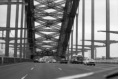
Heavy traffic on the Harbour Bridge, 1976... yeah, right. This is heading north on the main roadway. It was intended to carry trains on the left (and it does) as well as the right (which it doesn't, and didn't, except on "maximum load test" day back in 1932). It did carry trams, however, with an extensive system on the north shore and an underground platform at Wynyard. All gone, replaced with cars, cars, cars and the odd bus.
More trampath near Manly, 1976
Sydney had one of the world's largest tram networks prior to about 1950... but it progressively got pulled apart in favour of buses, finally closing in 1961. We were left with trampaths in bushland settings, or weird reservations in the middle of roads... and the odd bit of steel in the road surface.
This is the climb from the Spit. The trams ran from here to Manly, and on to Narrabeen. What a useful service that would be today...
This is the climb from the Spit. The trams ran from here to Manly, and on to Narrabeen. What a useful service that would be today...
Trampath Manly 1976
I'm guessing this is the trampath from the Spit to Manly, as it was in 1976: overgrown. It could be the path to Balmoral (similarly overgrown) but I'm going with Manly.
From a small clearing on the Manly side of the Spit Bridge the trams went up a twisting climb on the eastern side, joining up with the equally interesting old road up on Sydney Road. It was reserved track here in this pic, and again when it dropped down into Manly proper, leaving the road in an arc to the east (now home units) as the descent steepened, then west into the parkland surrounding the oval before joining Raglan Street.
There's a small monument at the Spit clearing and you can see the old bridge remains on the western side of the "new" bridge (ha, ha - I write "new" in an ironic sense). The old road goes west and climbs in a scenic fashion up to Sydney Road.
Trampath Watson's Bay - 1976
It was a long and winding reservation for trams up (and then down) to Watson's Bay. Plenty remains, including some interesting cuttings and tight curves that can be explored on foot... this is how the terminus looked in 1976.
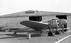
DC2 - Sid Marshall's collection - Bankstown
A view of what appeared to me at the time to be Sid Marshall's "outdoor" collection on a smallish block of land next to Bankstown Airport. You don't find this sort of treasure trove these days. It's circa 1974 I guess, give or take.
Marshall Airways Lockheed Electra Bankstown 1976
The sort of thing you went to Bankstown to see in 1976... The ex-Ansett Marshall Airways L10A Electra VH-ASM. Your typical sort of late 1930s airliner, really.
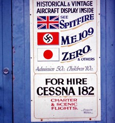
Museum door - Bankstown
The sign on the door to the Marshall Airways hangar says it all really. It's sometime in the 1970s I guess and you can see a Spitfire, an Me109 and a Mitsubishi Zero for 50 cents (adult). That's good value, eh?
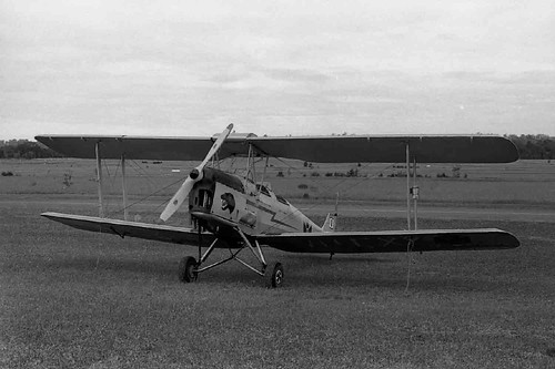
Tiger Moth VH-GWG Bankstown 1976
A DH Tiger Moth, at least 6 DHC Beavers, a DC-3 over near the Hawker de Havilland factory... and a Mobil fuel tanker. It has to be Bankstown Airport in 1976, surely?
The de Havilland factory at Bankstown churned out Mosquito bombers during WWII, but had resorted to making recreational boats to keep, umm, afloat. They also maintained and restored some interesting aircraft over the years. These days they make parts for companies like Boeing.
The de Havilland factory at Bankstown churned out Mosquito bombers during WWII, but had resorted to making recreational boats to keep, umm, afloat. They also maintained and restored some interesting aircraft over the years. These days they make parts for companies like Boeing.
Tiger Moths at RAAF Schofields Sept '76 - or was that HMAS Nirimba?
An Air Show at where? Schofields? Well yes. It was a Naval Air Station (HMAS Nirimba) for many years, boasting an intersecting set of 3 runways in a triangle formation. This is a shot from 1976, showing Tiger Moths in formation during one such air display - before we lost yet another airport.
Of course it wasn't always HMAS Nirimba. First of all it was land occupied and managed by the Darug peoples for thousands of years.
Post-invasion, 2 land grants were made in 1814 and 1816, to Major West and John Pye respectively, forming the essential extent of the future Schofields Aerodrome, Quakers Hill, site. The land was duly acquired in 1941 as a satellite field to RAAF Richmond. Construction commenced in 1942 but with the formation of the British Pacific Fleet in November 1944 it was decided to allocate the airbase to the Royal Navy (RN) as a MONAB (Mobile Naval Air Base). MONAB III arrived and the base became the RN's HMS Nabthorpe on 5 February 1945. However just a few months later, in November 1945, the RN shut down Brisbane-based MONAB VI, or HMS Nabstock, and transferred most of its personnel and equipment to Schofields. Thus Nabthorpe morphed into Nabstock.
Following the war's end the Royal Navy vacated the base (c.1946). It duly reverted to the RAAF and once again became known as RAAF Schofields. But not for long!
In 1952 the RAN moved in, re-establishing a naval atmosphere. The base was duly commissioned HMAS Nirimba, RANAS Schofields, on 1 April 1953. Or maybe that was Royal Australian Naval Air Repair Yard (RANARY) Schofields. No, it wasn't an April Fool's Day prank. Whilst the plan was to make it an aircraft repair facility as well as an aircraft technical training school, it was the training function that umm, took off.
Why Nirimba? Naval air stations were traditionally assigned the names of sea birds, and the name 'Nirimba' is derived from an Eora Aboriginal word meaning 'pelican'; thus the pelican became the main theme for the HMAS Nirimba crest.
Sadly, according to one source, the responsible Federal politicians and adminstrators were heavily lobbied by the local aviation industry to get out of the aircraft repair and maintenance side of things and, of course let private industry do that instead. And the RAN being about ships not planes (at least in the eyes of some) it came to pass that on January 4, 1956 RANAS Schofields (or was that Royal Australian Naval Air Repair Yard (RANARY) Schofields?) was decommissioned. And on the following day the Royal Australian Navy Apprentice Training Establishment (RANATE) was commissioned instead. To complete the bureaucratic/administrative side of things and lend an air of gentle farce to it all the name Nirimba was also decommissioned on 4 January; but like a Phoenix rising from the ashes, it was recommissioned the very next day.
Of course it didn't last, but it had a good run. Nirimba finally decommissioned - for good, in an RAN sense - on 25 February 1994. In time most of the land, well the southern or building-side of the base, anyway, passed into the hands of the University of Western Sydney and other educational institutions. The name 'Nirimba' thus lives on as an educational precinct.
A good source of naval-era pics here.
When it was operational, both as Nirimba and as a civil airfield, it was probably just a bit too close to RAAF Richmond: big brother was always watching. Although it was a nice, quiet and well-designed place to do touch-and-goes, as I did as a student pilot during the late '70s, you had to be precise. As long as you kept clear of Richmond's airspace and its all-seeing radar, all was fine. But should you cross that invisible line - watch out!
 There was an aero club building in the north-east corner and the HMAS Nirimba facility itself to the south. One day in - I think - the early or mid 1970s a DC-3 landed at the strip and parked near the aero club. Before it flew away a fence was erected to cut the long strip somewhat shorter. No, I don't know how it left the field - presumably by truck?
Another Tiger Moth at Schofields, 1976.
Schofields aerodrome was also a motorsport venue from 1950-59 (possibly that conflicts with the RAN records of operation there in 1953, though - shared use?).
The RAAF airfield data c.1944 describes three intersecting, graveled runways with "flight strips" (cleared, grassed and semi-prepared runway) either side. The graveled runways were 150ft wide and measured 3965, 4575 and 5030ft each in length, respectively. The adjacent flight strips were also all 150ft wide but measured 4400, 4975 and 5380ft respectively. In 1944 dispersal was incomplete (no confirmation on completion) and partially constructed hideouts were situated in "sparsely timbered" sections of Quakers Hill. The pre-existing roads of the town were widened and cleared to give enough width to taxi aircraft (to the hideouts!). The graveling of these taxiways was incomplete in 1944. A few huts and old farm houses reportedly occupied the western side of the intersection of two of the flight strips. By 1944 three hideouts were cleared, two were wire meshed and five others were cleared and formed.

Schofields has been closed since c.1994, although some operations were reported up to 1998. Now a housing and educational site, with aerodrome land, including a 'blimp hangar' and remaining portions of runway on sale from 2008. Grab yourself a bit of history.
Selected sources/further reading:
Some more detail available at There's a War On!
Some RAN seabird history
More detail on RN MONABs.
Checkout my list of Sydney and surrounding airstrips and airports.
Of course it wasn't always HMAS Nirimba. First of all it was land occupied and managed by the Darug peoples for thousands of years.
Post-invasion, 2 land grants were made in 1814 and 1816, to Major West and John Pye respectively, forming the essential extent of the future Schofields Aerodrome, Quakers Hill, site. The land was duly acquired in 1941 as a satellite field to RAAF Richmond. Construction commenced in 1942 but with the formation of the British Pacific Fleet in November 1944 it was decided to allocate the airbase to the Royal Navy (RN) as a MONAB (Mobile Naval Air Base). MONAB III arrived and the base became the RN's HMS Nabthorpe on 5 February 1945. However just a few months later, in November 1945, the RN shut down Brisbane-based MONAB VI, or HMS Nabstock, and transferred most of its personnel and equipment to Schofields. Thus Nabthorpe morphed into Nabstock.
Following the war's end the Royal Navy vacated the base (c.1946). It duly reverted to the RAAF and once again became known as RAAF Schofields. But not for long!
In 1952 the RAN moved in, re-establishing a naval atmosphere. The base was duly commissioned HMAS Nirimba, RANAS Schofields, on 1 April 1953. Or maybe that was Royal Australian Naval Air Repair Yard (RANARY) Schofields. No, it wasn't an April Fool's Day prank. Whilst the plan was to make it an aircraft repair facility as well as an aircraft technical training school, it was the training function that umm, took off.
Why Nirimba? Naval air stations were traditionally assigned the names of sea birds, and the name 'Nirimba' is derived from an Eora Aboriginal word meaning 'pelican'; thus the pelican became the main theme for the HMAS Nirimba crest.
Sadly, according to one source, the responsible Federal politicians and adminstrators were heavily lobbied by the local aviation industry to get out of the aircraft repair and maintenance side of things and, of course let private industry do that instead. And the RAN being about ships not planes (at least in the eyes of some) it came to pass that on January 4, 1956 RANAS Schofields (or was that Royal Australian Naval Air Repair Yard (RANARY) Schofields?) was decommissioned. And on the following day the Royal Australian Navy Apprentice Training Establishment (RANATE) was commissioned instead. To complete the bureaucratic/administrative side of things and lend an air of gentle farce to it all the name Nirimba was also decommissioned on 4 January; but like a Phoenix rising from the ashes, it was recommissioned the very next day.
Of course it didn't last, but it had a good run. Nirimba finally decommissioned - for good, in an RAN sense - on 25 February 1994. In time most of the land, well the southern or building-side of the base, anyway, passed into the hands of the University of Western Sydney and other educational institutions. The name 'Nirimba' thus lives on as an educational precinct.
A good source of naval-era pics here.
When it was operational, both as Nirimba and as a civil airfield, it was probably just a bit too close to RAAF Richmond: big brother was always watching. Although it was a nice, quiet and well-designed place to do touch-and-goes, as I did as a student pilot during the late '70s, you had to be precise. As long as you kept clear of Richmond's airspace and its all-seeing radar, all was fine. But should you cross that invisible line - watch out!
Another Tiger Moth at Schofields, 1976.
Schofields aerodrome was also a motorsport venue from 1950-59 (possibly that conflicts with the RAN records of operation there in 1953, though - shared use?).
The RAAF airfield data c.1944 describes three intersecting, graveled runways with "flight strips" (cleared, grassed and semi-prepared runway) either side. The graveled runways were 150ft wide and measured 3965, 4575 and 5030ft each in length, respectively. The adjacent flight strips were also all 150ft wide but measured 4400, 4975 and 5380ft respectively. In 1944 dispersal was incomplete (no confirmation on completion) and partially constructed hideouts were situated in "sparsely timbered" sections of Quakers Hill. The pre-existing roads of the town were widened and cleared to give enough width to taxi aircraft (to the hideouts!). The graveling of these taxiways was incomplete in 1944. A few huts and old farm houses reportedly occupied the western side of the intersection of two of the flight strips. By 1944 three hideouts were cleared, two were wire meshed and five others were cleared and formed.
Schofields has been closed since c.1994, although some operations were reported up to 1998. Now a housing and educational site, with aerodrome land, including a 'blimp hangar' and remaining portions of runway on sale from 2008. Grab yourself a bit of history.
Selected sources/further reading:
Some more detail available at There's a War On!
Some RAN seabird history
More detail on RN MONABs.
Checkout my list of Sydney and surrounding airstrips and airports.
Friday, May 30, 2008
Sydney Airport rwy 16 departures 1976
It's a queue for takeoff. Looks like a DC8 lined up on runway 16, with a waiting gaggle consisting of a TAA 727, an EWA F27 and a couple of Ansett DC9s. And look in the background for Sydney to the north and east, including the Sydney Harbour Bridge on the right. This is 1976 and I'm guessing that is a very early shot of an incomplete Centrepoint Tower, far right.
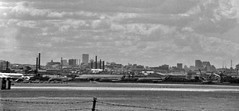
Almost finished - Centrepoint Tower
Another view of Sydney's skyline, including a much more complete Centrepoint tower... this is looking north from near the crossing of the (then) 2 runways at Sydney Airport (1979). That's a Malaysian DC10 of course.
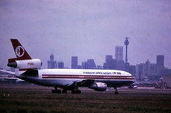
F27 VH-EWL Crash-salvage at Bankstown
Ouch, that hurt. If I remember rightly VH-EWL came down outside of Bathurst, the victim of windshear during a storm. It hit high ground on approach (or was it departure?) and basically landed, ummm, prematurely. No-one was seriously injured (to my knowledge) but the airframe was flattened on the bottom as it skidded along... it ended up here on the Condell Park side of Bankstown, up against a low fence. Whilst the markings were clumsily obscured it was pretty obviously the F27 "Friendship" in question!
"PROBABLE CAUSE: "During the climb performance of the aircraft was adversely affected by an unpredictable encounter with a large change in the horizontal wind component, and an associated downdraft, at a height too low to effect recovery." (Dept. of Transport Australia Accident Investigation Report 76-2) "
Worth a mention: there was a WWII military bunker nearby to this site, on the hill behind this shot. I'll post more on that later but it was a seriously large and well hidden centre.
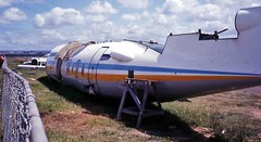
Trans International DC8 Sydney 76_933
Sydney Airport was a great place to visit in the 70s. You could move around with ease and no-one really cared what you did. So there I was one day sitting atop a shipping container near the Adastra hangar when this TIA DC-8 Super 63 thundered past my lens. It's runway 25.
This was the most interesting part of Sydney Airport in many ways, with a great view of the "short" runway plus the old Lincoln fuselage to look at across the swamp (used for firefighting practice). Behind those trees is the burned out wreck, with 2 tailplanes just visible (if you have enough imagination). A Pan Am 707 once over-ran the runway whilst taking off on the reciprocal (ie 07, not 25). Apparently a victim of bird-strike, it ended up in the mud at the end of the strip. That was about 1970 or so. A few years later a Pan Am 747 landed long on 25 and did a hard-right turn to just miss the main sewer outfall (and Cook's River).
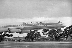
This was the most interesting part of Sydney Airport in many ways, with a great view of the "short" runway plus the old Lincoln fuselage to look at across the swamp (used for firefighting practice). Behind those trees is the burned out wreck, with 2 tailplanes just visible (if you have enough imagination). A Pan Am 707 once over-ran the runway whilst taking off on the reciprocal (ie 07, not 25). Apparently a victim of bird-strike, it ended up in the mud at the end of the strip. That was about 1970 or so. A few years later a Pan Am 747 landed long on 25 and did a hard-right turn to just miss the main sewer outfall (and Cook's River).
TAA aircraft maintenance Sydney 1976
A moody shot of the TAA maintenance hangers in 1976. Sydney Airport still had some rustic charm away from the 2 main domestic terminals, including some old residences that had been taken over, undeveloped grassy blocks and easy all-day parking.
Out of shot behind me is the Adastra hangar where a Lockheed Hudson could be found lurking, as well as some remains of the old Pony Racecourse and Lord's Rd "Balloon Loop" for the trams.
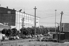
Out of shot behind me is the Adastra hangar where a Lockheed Hudson could be found lurking, as well as some remains of the old Pony Racecourse and Lord's Rd "Balloon Loop" for the trams.
The day a JAT 707 tried to land at Bankstown
Telling tales out of school now, but...It may be my fading memory at fault but I seem to recall one JAT proving flight into Sydney (possibly in 1974 or so) where the tower asked the 707's captain to confirm altitude. The conversation was along the lines of "you are too low" and "you are below the glideslope". The approach was from the west over Bankstown and indeed the pilot had mistaken Bankstown Airport for Sydney. Or so the story goes! (No harm done, they found runway 07 eventually.)
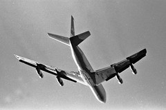
Subscribe to:
Posts (Atom)