Thursday, December 31, 2009


NSW Premier J J Cahill: railwayman, unionist with strong Marrickville links
CAHILL, JOHN JOSEPH (1891-1959), railway fitter, trade unionist and premier, was born on 21 January 1891 at Redfern, Sydney, son of Irish-born parents Thomas Cahill, labourer, and his wife Ellen, née Glynn. The family was part of the tightly-knit community of railway workers that had grown up around the Eveleigh railway workshops. Educated at St Brigid's convent school, Marrickville, and Patrician Brothers' School, Redfern, on 2 July 1907 Joe was apprenticed as a fitter at Eveleigh. He joined the Workers' Educational Association, regularly attended lectures and developed his public-speaking skills in debating societies.
An officer of Marrickville branch of the Amalgamated Society of Engineers (Amalgamated Engineering Union from 1920), Cahill went as a delegate to union conferences. He was dismissed from his job on 14 August 1917 for his part in a railway strike and his personal file was annotated 'agitator'. There followed a lean period in which Cahill found it difficult to obtain regular employment. At one stage he was reduced to selling insurance. Prominent in the early 1920s in an unsuccessful revolt by a group of activists against the A.E.U.'s governing body, he was banned from holding office in the union until mid-1925. In May 1922 he was re-employed by the railways. At St Brigid's Church, Marrickville, on 11 November that year he married Esmey Mary Kelly; they were to have a long and happy family life.

Addison Rd Centre - or Barracks - linked to Gumbramorra Swamp and farming
The site of the Addison Road Centre (ARC) in the suburb of Marrickville was once natural wetlands known as the Gumbramorra Swamp which was drained in 1890. The original residents of this area were the Cadigal Wangal People who lived in the area for more than 40,000 years. The Cadigal were a clan of the Darug people and spoke the coastal Eora language. Clans of the area included the Wangal, the Kameygal and the Bediagal. More information can be found here and especially the Cadigal Wangal website here also.
Incredibly despite massive disruption to the First Australians through colonisation we believe there are still descendants of the Cadigal alive today living in this area.
Local farmland for market gardens
There is evidence of a stables and hayloft on the site (which is now the main office, gallery and studios) possibly related to farming or army barracks

Interesting cycling item in the Powerhouse Museum collection, with Marrickville connections
Fred's wife Hylda was born Hilda Williams on 9 March 1887 at Goulburn. When she was young they lived in a tent by Cooks River at Earlwood. They built a home in Garners Ave Marrickville. She and her sister Mabel formed the Trevena Sisters, a singing/dancing vaudeville act. The sisters learnt to dance and joined a travelling show, and experienced the excitement of being 11 year-old girls travelling in a covered wagon. They eventually became well-known vaudeville entertainers.
Hylda and Fred married in 1909 at St Clements Church Marrickville. The donor was born Fay Trevena Klimo in 1922, one of six children. Her name contained the stage names of both parents. She married Ray 'Bud' Abbott. When Bullen's Circus first came to Sydney, Fred got Ray a job there as the drummer and panotroper (responsible for operating the panotrope, a sound system that provided mechanical music).

"Norwood township", Petersham and Henson Park: a resident blogger
The position of NORWOOD for a Township, is one of the
MOST ELIGIBLE
To be found in the COLONY. It occupies that picturesque and
Splendid Site,
PETERSHAM HILL,
Immediately over the
RAILWAY STATION,
Any portion of the Town being within FI VE MINUTES WALK
of the Station. The TRAINS to and from Sydney will not oc-
cupy more than TEN MINUTES, thus affording a
PLEASANT, ECONOMICAL, AND EXPEDITIOUS
MODE OF TRAVELLING
To the Metropolis, the distance being only
THREE AND A HALF MILES.
NORWOOD is also accessibly either by the
PARRAMATTA ROAD,
By which it is about Twenty Minutes drive to Sydney or
THE NEW TOWN ROAD,
passing by Enmore. From the great elevation of the town, it
commands views of EXCEEDING BEAUTY: towards the
north-east there is a most
MAGNIFICENT LANDSCAPE,
Including
BOTANY HEADS,
THE BAY,
THE PACIFIC OCEAN,
NEWTOWN, and all the adjacent country, several GENTLE
MEN’S SEATS diversifying the scene. Also a most picturesque
view of NEWTOWN CHURCH.
Towards the south-west there is altogether a different character
of landscape and equally as pleasing in the immediate foreground,
is the Railway Station.
[...]
The auctioneers could dwell much longer on the pleasing duty
of illustrating the splendid site selected for Norwood, but they
think enough has been said to awaken the desire of intending
purchasers to see themselves the beauties of nature displayed to
such advantage.

Sydney's first fire station - at Marrickville
All fire stations were given a number as they were built, starting with Headquarters or No 1, but City of Sydney was not actually the first fire station built for the MFB, the honour going to Marrickville which was opened in 1886.

Silent star Annette Kellerman, born in Marrickville, 1886
Born in 1886 in Marrickville, Sydney, Kellerman was a NSW swimming champion who left for England aged 18 to help her cash-strapped family. In Europe, she built a name for herself in long distance swimming and exotic swimming and diving demonstrations. By 1906 she had moved to vaudeville theatre in America as 'Australia's Mermaid' and quickly progressed to the big screen. Kellerman enjoyed tremendous success as a silent movie star in mythological underwater films, including Neptune's Daughter.

Suffrage, the Wolstenholmes and Maybanke House, Marrickville
Maybanke Susannah Anderson also known as Maybanke Wolstenholme (February 17, 1845 - 1927) was a Sydney reformer involved in women's suffrage and federation.
Maybanke Susannah Selfe was born at Kingston-upon-Thames, Surrey. Her family emigrated to Australia as free settlers when she was nine years old. Twelve years later in September 1867 she married Edmund Kay Wolstenholme, a timber merchant. The couple had seven children between 1868 and 1879, four of them died form a heart condition before the age of five. The Wolstenholmes built a large house called ‘Maybanke' in Marrickville. The later years of the marriage were unhappy, Edmund had a number of business failures and became and alcoholic, leaving the family in 1884. Maybanke has to wait for the passage of the Divorce Amendment and Extension Act in 1892 before she could divorce Edmund on the grounds of desertion, the divorce was finalised in 1893.

Webster - Marrickville quarryman
WEBSTER, WILLIAM (1860-1936), quarryman and politician, was born on 7 June 1860 at Everton, Lancashire, England, son of John Webster, labourer, and his wife Elizabeth, née Poynton. One of a large family, William left school at 13 to work in the Welsh quarries. Migrating to New South Wales in 1879, he quarried stone at Pyrmont and, by diligent saving, was able to bring the rest of his family to Sydney. By 1880 he was prominent in the Quarrymen's Union of New South Wales and financial secretary of the Trades and Labor Council. On 7 June 1883 at St Clement's Anglican Church, Marrickville, he married Jane Buckney. Webster Bros, the quarrying firm he founded at Marrickville, was among the first in New South Wales to observe an eight-hour day and standard wage.

Newtown, Marrickville and Marcus Clark & Co
From a modest start in the Sydney suburb of Newtown in 1883, Marcus Clark & Co rose to become one of the city's largest department stores with a network of branches in towns and suburbs across Australia. Henry Marcus Clark (1859-1913) established the company when he purchased the drapery business of his former employer, John Kingsbury. The business quickly expanded, trebling itself within five years, and soon opened new stores in Marrickville and Bondi Junction. In the Sands directory for 1894, Marcus Clark was listed as a "wholesale and retail draper, tailor, milliner, boot warehouse and fancy repository; the largest, best lighted and most comfortable establishment in Newtown, the floor space covering nearly an acre."


Newtown - Sands 1909 directory - street by street, name by name
NEWTOWN,
INCLUDING
SOUTH KINGSTON.
BOUNDED on the north by municipality of Camper- south by Erskineville and St. Peters; and on the west down; on the east by Redfern and Darlington; on the by Petersham and Marrickville. Proclaimed a Municipality, 12th December, 1862, Area—480 acres. Number of houses—5,500. Number of assessments—5,740. Miles of streets—26|. Assessed Value—£193.160 10s. Annual rental—£212,390. Estimated Capital Value of all Ratable Properties—£3,540,272 4s. Council Chambers—Town Hall, King-street.

Erskineville - Robert Henderson of Henderson Road and the gravelling of Erko Road
Robert Thomas Henderson
Alderman for O'Connell in 1871-76
His father was Robert Henderson (1798-1865) whom the 'Gardeners Magazine' of February 1865 says superintended the layout of the 'once-famed gardens' of Alexander MacLeay's Elizabeth Bay House estate. His mother Elizabeth was daughter to Thomas Shepherd who operated the nursery in Chippendale from the 1830s which was known as the Government Nursery or the Darling Nursery because, as Victor Crittenden says, it was vice-regally approved by Governor Ralph Darling. (Francis Low's Directory of 1844-45 mentions a James Henderson working at the Darling Nursery.)
Robert Henderson married Elizabeth Shepherd in 1831 and started the Camellia Grove Nursery in 1838 on four acres nearby in the low lands in what was the Kingsclear grant of 1794 and now is land on the corner of Henderson Road and Park Street Erskineville. The first son Robert Thomas Henderson was born in 1837, brother Charles JBN Henderson in 1845.

Newtown Mayor with a Cook's River Road address - William Bailey
Mayor William Bailey JP
Mayor 1871-76, Councillor/Alderman 1863-64, 1867-78
He was a builder, he was no doubt pragmatic and the longest-serving of the early mayors.
His place of residence is unclear according to the Sands Directories; in Cooks River Road in 1858, in Station St/Enmore Rd between 63 and 71 (in 'Camborn Terrace' between Cooks River Road and Union St), in Cavendish Street in 1873 and in Enmore Rd in 1877 and at Trafalgar Terrace in 1886.
It is said that he belonged to the Church of England but this should be checked as the Sydney Mail of 10 August 1861 reports that a certain Mr W Bailey was appointed replacing Alderman Robert Dunlop to superintendent the Newtown Wesleyan schools.
He built the Congregational School which operated as a Sunday school and regular school. Thomas Holt MP officiated at the laying of the school's foundation stone on 23 January 1862, saying 'it is destined to be instrumental in working a great moral reformation in NSW' ('Sydney Mail'). Nicholas Trengrouse, a senior draghtsman in the Railway Department and an alderman in Marrickville's first council, designed it...
Marrickville and Fort Street link - Charles Haddon, dramatist
CHAMBERS, CHARLES HADDON (1860-1921),
dramatist,
was born at Sydney on 22 April 1860. His father, John Ritchie Chambers, who had a good position in the New South Wales civil service, came from Ulster, his mother, Frances, daughter of William Kellett, from Waterford. The boy was educated at the Petersham, Marrickville, and Fort-street schools, but found routine study irksome and showed no special promise.

Marrickville - another reference to Sans Souci and Thomas Holt
Holt, Thomas - Born in Horbury, Yorkshire, 14th November 1811. Was a proficient swordsmen and stickler for physical fitness. He vested into many enterprises including wool and establishing the AMP society. He built many mansions , some of which are the remains of Sutherland House, now a garden feature in a Sylvania home.

Marrickville linked with Sans Souci - via Thomas Holt and 'The Warren'
The area was originally a grant given to Catherine Cooper in 1830. The Coopers built a home on the land which was called Charlotte Point or Rocky Point. The Coopers later ran a distillery there. In 1853 Sans Souci (French for 'without care'), was named after the mansion built by Thomas Holt on Rocky Point road for his wife. Being too isloated, Mrs Holt refused to live in it so he built her another, 'The Warren' on the Cook's River at Marrickville. William Rust acquired the property and turned it into the Sans Souci Hotel and the suburb adopted the name Sans Souci. [Pollon 1991, p. 252.]

Marrickville - or Hurlstone Park, really - Sydney's first sugar mill
SUGAR MILL - Riverside Retreat
This striking apartment has been created within the elegant sandstone walls of Sydney's first sugar mill, built in 1841. Set on the banks of the Cooks River, the spacious security apartment occupies a serene cul-de-sac setting, just metres from parkland and waterfront walking trails. The unique residence is also within 18 minutes to CBD and close reach of the station, local shops and Marrickville Golf Course.

Marrickville - Meeks Road - named for James Meek, market gardener, and family
Title
"Stone Cottage", Harriett Street, Marrickville
Level of Description Series
Date of Work
undated [ca. 1880s]
Type of Material Graphic Materials
Call Number
SPF/695
Physical Description Photographs : cabinet card photograph ; 10.6 x 16.5 cm.
Administrative / Biographical Note
The Meek family arrived in the Marrickville district in 1839. James Meek Snr. was a market gardener.

Marrickville - Calvert Street - named for John Jackson Calvert
Calvert took an active part in community affairs; on 24 June 1878 he was appointed an additional member of the board of the Marrickville Public School; a street in Marrickville still bears his name. He was a trustee of the Sydney Domain, a founder of the Civil Service Club, and for some years a member of its house committee. He was a member of a number of commissions which attended to the representation of New South Wales at the Paris Universal Exhibition in 1878, the Adelaide Jubilee International Exhibition in 1887, the Centennial International Exhibition at Melbourne in 1888, and the World's Columbian Exposition at Chicago in 1893.

Sunday, December 27, 2009
Charles Street, Marrickville and surrounds - a potted history. Part 2
Or go back to Part 1!
"Clearance sale, Beer's Estate, Marrickville [NLA cartographic material] / to be sold by Watkin & Watkin on the ground on Saturday 27th Dec 1891 at 3.30 p.m. Sales plan for land in the suburb of Marrickville in Sydney, bordered by Illawarra Road, Horton Street, Charles Street and Addison Road. Terms! 10 per cent deposit. Balance - by equal payments at 1,2 & 3 years with interest 6% payable halfyearly. Torrens title".
Who was "Beer" and how did they come to own this land? I don't know. It was dairy farmland prior to that, and probably somewhat swampy. Illawarra Road passes right past and remains a narrow track, whereas the estate's streets are wider. Thomas Chalder's Marrick Village is just 100m or so away.
Anyway, on with part 2...
- "1920 - Airport (later Kingsford-Smith) at Botany. Extension of St Peters municipality to west of Unwin’s Bridge Road. Tresillian (built 1900) bought by Royal Society for the Welfare of Mothers and Babies." Tresillian was a 'mothercraft' home and I can recall my baby sister being weighed and measured in the front rooms in the early 1960s.
- "1920 - Fowlers set up main works in Fitzroy Street. 1921 - Census shows Marrickville, 42240; Petersham, 26236; St Peters 12700; Newtown 28169. St Brigid’s Church and monastery at Marrickville. Salvation Army Training College opened" (Livingstone Road).
- "1922 - Marrickville Town Hall opened" at corner of Petersham and Marrickville Roads.
- "1925 -Duly and Hansford in Carrington Road. 1926 - Electrification of Illawarra and Bankstown railway lines. Opening of city stations at Museum and St James’. 1927 - St Peters Town Hall, Unwin’s Bridge Road opened. General Motors plant in Carrington Road. 1928 -Abergeldie estate subdivision and sale (last major subdivision). Small’s Confectionery at Stanmore. Electrification of Parramatta railway line. Cooks River Road becomes Prince’s Highway. 1929 - Major extensions to Globe Worsted Mills, Sydenham. Onset of Depression brings severe unemployment to industrial Marrickville. 1931 - Census deferred until 1933 but population estimates for 1931 were Marrickville 46590; Petersham 28340; St Peters 13890; Newtown 28660."
- "1932 - Opening of Sydney Harbour Bridge and Town Hall at Wynyard stations. Henson Park created on site of Daley’s brickworks became Rugby League Centre." This statement undervalues our history - it was a cycling facility, a big velodrome, that drew thousands of people to weekly night-time races. It also hosted the closing ceremony of the 1938 Empire Games. Charles Street remains an important access road to Henson Park if you are travelling from the north and east.
- "1936 - General Motors move to Pagewood: Carrington Road site occupied by Davis Coop Cotton." The GM Pagewood plant took over the site of one of Australia's largest film studios, National Studios. When GM vacated the plant in the 1970s it was redeveloped into a shopping centre and a bus depot.
- "1936 - Crago Flour Mill silos erected. 1938 - Opening of new Petersham Town Hall on site of old Hall. 1939 - Outbreak of World War Two. Despite manpower and material shortages, war gave a fillip to Marrickville industry. Development of Welfare groups under patronage of municipal councils. 1941 - Census deferred until 1947 but population estimates for 1941 were Marrickville 46300; Petersham 27580; St Peters 12520 ;Newtown 24630. The population had declined slightly over the decade.
- "1942 - Metal Processors set up at Donney’s Works. 1945 - End of World War Two. 1947 - Beginning of new migration policy and rapid rate of arrivals. 1948 - Local Government Areas Act: Marrickville, St Peters and Petersham combined as Marrickville. Most of Camperdown Cemetery resumed as Rest Park. 1949 - New Marrickville Municipality with headquarters at former Petersham Town Hall. Seymour’s Store (est. 1900) destroyed by fire. 1950 - Globe Worsted Mill moved to Victoria. 1953 -Beginning of decline in number of smaller manufacturing concerns in Marrickville. 1954 - Population (on 1969 boundaries) 95189."
- "1957 - Tramway services discontinued; replaced by buses. Conversion of Tempe Depot. Camdenville Park on site of Speare’s Brickworks. 1960 - Midden deposit and stone axe head were found at Marrickville Golf Course. 1961 - Population (on 1969 boundaries 91396; the first census to contain a significant number of inhabitants born overseas, other than in the U.K. and N.Z.
- "1962 - Beginning of large scale flat (later home unit) development. Vicars merged with Australian Woollen Mills. 1966 - Population (on 1969 boundaries) 92745. Greek Orthodox church in Marrickville Road. 1968 - Marrickville expanded to include Enmore and parts of Camperdown. Incorporation of South Sydney (originally Northcote) municipality. Fowler’s Potteries taken over by Newbold General Refractories. Coptic Church in former Methodist Church in Railway Road, Sydenham. 1971 - Population 98700 (including 13171 of Greek origin). "
- "1974 - Marrickville Administrative Centre, Petersham, opened. 1975 - Fowler’s ceased to produce pottery at Marrickville. 1976 - Population 90750. Vicars Woollen Mills company wound up. Addison Road Community Centre set up", replacing the Army barracks and stables.
- "1980 - Salvation Army Training College relocated to Bexley", from Livingstone Road. 1980 - Marrickville Margarine complex, Edinburgh Road, sold." This site was lit up with an impressive (for its day, anyway) Christmas display every year. It became the site of Marrickville Metro shopping centre in 1987. "1981 - Population 83448. 1982 -Fowler’s Pottery demolished and land subdivided. Reference: Marrickville Council website.
- Also useful to look up is the History of Transport, Marrickville
- Marrickville South and the Warren is referenced as well at the Council site: "Before Richardson’s Lookout, there was only The Warren, a remarkable castle-like structure owned by Thomas Holt. The surrounding estate was filled with rabbits for sport, alpacas and other exotic animals, and Holt used the hunting grounds to entertain royalty and other guests. When he returned to London in 1886 (to help the Salvation Army and Dr Barnardo), he left his estate to Carmelite nuns. In World War I, The Warren was modified by the government into housing for returned soldiers. After the war, The Warren was demolished, and the site left abandoned until a Marrickville alderman named Warren Cook Richardson led a campaign to revitalise the park. It was renamed in his honour in 1936 and all that is left of The Warren are two pillars taken from the demolished house".
- And the National Library contains useful details (and maps) of subdivisions, such as this "sales plan for land bounded by Livingstone and Marrickville Roads, and Francis, Arthur, Stanley, Lilydale Streets, Marrickville, New South Wales. * Oriented with north to left.* Torrens title"
- And "Pilgrims Estate, Marrickville [cartographic material] : close to the tram on Marrickville Road / auction sale on the ground, Saturday 12th December, 1908, at 3 o'clock ; Richardson and Wrench Ltd., 98 Pitt St., auctioneers"
- And "Plan of allotments at Marrickville between Victoria Road and Chapel Street with Harbers Land adjoining. Also available in an electronic version via the Internet at: http://nla.gov.au/nla.map-f642d"
- And "Local sketch, Tracing of allotments between Crinan Street and New Canterbury Road Marrickville. Also available in an electronic version via the Internet at: http://nla.gov.au/nla.map-f615a "
- And also "The Warren, Marrickville [cartographic material] : the property of the Excelsior Land, Investment & Building Co. and Bank Limited : first subdivision (1893). Sales plan for land in the suburb of Marrickville in Sydney, bordered by Illawarra Road, Premier Street, Cary Street, Renwick Street, Warren Road, Park Road, and Excelsior Parade. This magnificent estate, so well known as the late residence of the Hon. Thomas Holt, has now been subdivided, and the directors of the above company have much pleasure in submitting a portion of it to the public with every confidence that it will be appreciated as it deserves. Purchasers of land on land will enjoy the following advantages:- healthy and elevated position, splendid views, good soil, excellent drainage, wide roads, 66 and 80 ft., large reserves, and above all, easy access to the city by tram, bus, and railway, as the tramway is now completed for sale, the 'bus runs regularly, and the Illawarra Railway line is surveyed to pass right through the estate. Every facility is given by the company for the erection of dwellings, etc., on the estate. 90 per cent of the cost of building will be advanced, or the company will themselves undertake the erection on their well-known liberal terms. This is the best guarantee that the value of the land will increase rapidly, as where buildings are constantly being erected land is sure to rise also. For example, the Elswick Estate was subdivided by this company twelve months ago, there are now over 200 buildings and the land has increased in value some 25 per cent. Take particular notice of the liberal terms of sale ... T. S. Parrott, Surveyor, 57 Pitt Street".
- And "allotments in the estate of the late Joseph Graham Esq., J.P., Marrickville [cartographic material] / for auction sale on the ground, Saty. 22nd Dec. 1894 ; W. Pritchard & Son, auctioneers, 100 King St., Sydney. Sales plan for land bounded by Livingstone and Marrickville Roads, and Francis, Arthur, Stanley, Lilydale Streets, Marrickville, New South Wales."
- And at "The Grove, St. Peters [cartographic material] : close to Marrickville Railway Station : for auction sale on the ground, by order of the mortgagees, Saturday 1st July 1893 at 3 o'clock / by W. Pritchard and Son ; G.H. Barrow, draftsman Sydney.
- And "a sales plan for land in the suburb of Sydenham in Sydney, New South Wales, bounded by Creagh Street, George Street, Yelverton Street and Cook's River Road. Torrens title. Note: The vendors reserve to themselves the right of closing or altering the lane between the unsold portions of the Estate. Arnold W. Love, surveyor under Real Property Act, St. James' Chambers, King Street. Easy terms. North is oriented slightly to the right. Valuable properties of Thos. Chalder Esq [cartographic material] : St. Peters, Cooks River Road : to be sold on the ground on Monday 22nd March 1875, at half past 2 o'clock / by W. Pritchard."
- And lastly (for me, you can keep searching if you want) "Marrickville [cartographic material] : 14 good building lots, splendid position / for auction sale, on the ground, Saturday, August 4th, 1900, at 3 p.m. ; by Hardie & Gorman, auctioneers. Sales plan for bounded by Petersham and Illawarra Roads, Marrickville, New South Wales. Includes local sketch. Printed in red. Torrens title. Terms: 1/4 cash deposit & the balance in 1, 2 & 3 years at 5 per cent interest."
Charles Street, Marrickville and surrounds - a potted history. Part 1.
- In fact I grew up in Charles Street, so this web reference to Stuart Alchin Laing, "born at Marrickville in May 1896" is interesting. Stuart left a will dated 23rd August 1917 stating in part that "I devise and bequeath all my real estate unto my mother Charlotte Laing wife of Charles (sic) Laing of “Tara” Charles Street Marrickville Sydney in the State of NSW. ”
- Do I know which house was the aforementioned "Tara"? No, but I'll keep looking...
- Interesting that the Princes Highway was, in part, called Cooks River Road, extending as you'd expect from Parramatta Road to Cooks River. Before that it was known as Bulanaming Road (until the 1820s) and perhaps also as Newtown Road (once New Town store lent its name to the district, anyway.
That's enough for now - or on to part 2!
Friday, December 4, 2009
Sydney's airports - more than just one
There's RAAF Richmond, roughly adjacent to and north of the old Clarendon airfield.
Nearby neighbour RAN base Schofields, a bit too close to Richmond to survive, so it didn't.
Of course there's Sydney(Kingsford-Smith), but that's obvious.
And of course Bankstown, a big, busy GA field with a long history, hemmed in by development but hanging in there.
And Top Gear Australia for a brief time made the most of Camden's distance from Sydney to make use of its quiet taxiways for TV car tests. It's a useful and historical airfield that plays a key role in training and GA work but remains fairly underused.
And Hoxton Park has been axed. chopped up and largely built over.
There's also long-lost Hargrave Park - too close to Bankstown - that is just a memory, and a collection of interesting street names
Did I say long-lost? How about the Jamison Park airfield at Penrith
And many more ex-WWII airstrips dotted around the city's extremities, most lost, a few active like Oaks Airfield or not, like at St Marys.
Checkout my list of Sydney and surrounding airstrips and airports.
More interesting places to virtually visit
The curves left behind... take the trams away and you just have an oddly-shaped street with a touch of curving mystery at both ends...
Above, Chippo's Meagher Street
Above is Eddy Ave at Central Station, including ramps (later reused for the current 'light rail').
North Sydney station, where the trams ran to the north of and parallel with the railway, running up a ramp (now used as a car park) and across a bridge (over the roadway) to a tram station opposite the Milson's Point railway station. From there they ran on reserved track on the opposite side of the Harbour bridge from the railway, entering a tunnel and terminating at Wynyard.
Above, Randwick Racecourse had it its own tram station, with platforms and an overhead bridge. You can still see some of this structure.
Above and below, Anzac Parade - the busway seen here was once reserved track, and there was a lot of it from here down past the SCG and the Showground and along Alison Road as well. There was reserved track on both sides of Anzac Parade in places, as well as in the central reservation further towards Maroubra.
Interesting yet discarded - part 2
Another bridge, further down the Parramatta River... at Gladesville. You can see where 'Victoria Place' diverts from current Victoria Road, running down to a lower-level bridge. There is a similar arrangement on the northern bank with a strangely-wide and curved road leading from the ferry wharf. You can picture the trams climbing up to Drummoyne, can't you?
And another, but on the Hawkesbury River near Brooklyn. It was Peat's Ferry, in its day the only way across the river by motor vehicle. Replaced with a bridge that was then semi-replaced with a Freeway. Note the roof of the mothballed eat-in/drive-in '50s-style roadhouse:
Meanwhile, down south on the Georges River, Forest Road ends abruptly, as though you are meant to start swimming... or catch a ferry. There are 'remains' on both sides of the river. Forest Rd was the original road link to the Illawarra, so, like Peat's, this would have been a busy vehicle ferry.
Interesting yet discarded - part 1
The Maroubra Speedway was just about there... in what is now Coral Sea Park.
Old road bridge lost in the Christmas '94 fires... it was a wooden trestle bridge from memory, just east of the current Ryde Road. I always meant to photograph it, then it was gone...
Roseville. Interesting approach (Babbage Road) to a low level bridge, replaced by a higher one, of course! There was once a recreation/holiday camp/dance palais on the Forestville side of the river, too.
Iron Cove... another bridge that was, with just the ramparts left on both sides... and note that there's a tram lane on the "new" bridge, too, now used as a T-way:
Friday, October 23, 2009
Mod Daynighter
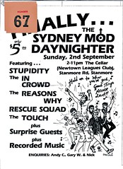
This is a scan of a cheap and cheerful Mod 'zine from circa 1980.
Mod Scene Club mag
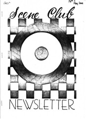
This is a scan of a cheap and cheerful Mod 'zine from circa 1980.
Wednesday, September 9, 2009
King Street - ahhh, what a streetscape
Read on for some local history... Kingston Farm, O'Connell Town, the Newtown Store, Burren Farm... I stumbled over this (via @Stilgherrian)
Heritage Branch Website - Listing Heritage Items - State Heritage Register - Item View
In the 1840s Newtown was described as 'a beautiful village of New South Wales, situated on the road to Cook's River, about three miles from the city of Sydney; it contains 323 houses and 1215 inhabitants, of whom 631 are males and 584 females'.

Monday, August 24, 2009
Marrickville's first Town Hall, Illawarra Road
The original Marrickville Town Hall was opened in 1879 as a single storey building, designed by John Michael Despointes, an architect and local brick maker. Despointes of course lent his name to Despointes Street, one of those locally fascinating facts that have perplexed a few people. It sounds French... why name a street in Marrickville after some obscure French person? Well now you know. In 1883 a second storey was added, to plans prepared by Blacket & Son Architects.
(Despointes Street, BTW, was a boundary of the "Frogmore Estate". Sales plans for land in the suburb showed that Frogmore was bordered by Marrickville Road, Petersham Road, Cecilia Street, Malakoff Street, Despointes Street, Illawarra Road, Frogmore Street, and Sydenham Road. Can anyone shed light on Frogmore itself? Was it a homestead? Was it related to the Frogmore at Werrington?)
Entering the old school building in the late 1960s via the front gate in the low wire fence you passed the brick milk crate shelter (where we got our small bottle of milk, free, if you could stand the cream at the top and the curdling from the heat - I certainly could, just) and went straight up the steps between resting lions. Fairly ornate wooden doors swung open to reveal a solid wooden staircase to the left - or was it 2, one on each side? Hmmm. The Principal's office was to the right, I think! Straight ahead was a classroom with a backdoor into a teachers library and common room, with a common room and kitchen. Exit to the playground on the left, and also I think to the street on the right. Upstairs was a larger, more ornately clad room that comprised a pupil's library and the assembly hall. The Queen of England was dead ahead, on the western wall. We faced her when we sang God Save the Queen (original, not the Sex Pistols version still to come). A staircase led down from the left hand side, facing west. Or so I think (memory can play tricks)!
Anyway, Marrickville Council built the "new" town hall (now another old one, since Council moved to Petersham at least) in 1922 on Marrickville Road, up against Petersham Rd. There was a wooden library at the back of that building. (Childhood immunisations were done in the main building, and I can remember paying rates with my mother at a small office upstairs.) Council sold the original Illawarra Rd building to the
Appropriately, given the late-60s/early 70s dominance by Greek immigrants, in 2006 the building was sold on to Atlas Hall Pty Ltd as Trustee for The Greek Atlas League of NSW. Apparently restoration works are progressing. Any updates out there?
There's a pic and more words here via Marrickville Council.
Cycling, Henson Park, Marrickville and the 1938 Empire Games
My dad used to catch rabbits at Henson Park, but before that locals took a dicey dip in the fathomless and sometimes deadly depths of the ponds in Daley's Brickworks. Marrickville Council even has some pics.
As a kid growing up in Marrickville myself I did wonder about the very slightly banked tarred oval - some 800m long from memory - it seemed like it to a bookish sub-10 year old asked to run around it at school athletics carnivals, anyway. It was lit by rusty lamps on rusty lamposts and surrounded by an equally rusty old, low wire fence decorated with scattered advertising hoardings. There were coloured lines that seemed indecipherable at the time but must have represented the duckboard, the inner edge line, the sprinters line and so on. Inside the oval was a football field, the home of the Newtown Jets, formerly the Bluebags.
The velodrome itself was the home of Dulwich Hill club until they were offered a much better deal - the 45 degree banked concrete Camperdown track. In return they gave up the big old saucer at Henson Park, with the Rugby League club taking over completely an dinstalling massive lighting towers for night matches. I'm pretty sure that Marrickville Council stumped up some of the cash for that, but it was a poor deal for Newtown RLFC anyway as they were still booted out of the first grade comp.
Still, that's the stuff of Sydney's history.
In brief:
- Henson Park was established in 1933 on the site of Daley’s brick pit
- Thomas Daley operated the Standsure Brick Company from 1886 to 1914. The brickworks occupied 3.6 ha. When the brickworks closed the pits filled with rain and ground water, forming waterholes, of which “The Blue Hole” was the biggest
- Marrickville Council purchased the site in 1923 as it was a serious danger to the braver local kids
- Henson Park was officially opened in 1933 with a cricket match between a Marrickville Eleven team and a North Sydney District team, including Don Bradman
- Henson Park was named after William Henson, Mayor of Marrickville in 1902, 1906 to 1908 and his son, Alfred Henson, who was an Alderman of Marrickville Council from 1922 to 1931
- Henson Park hosted the cycling events and the closing Games ceremony of the 1938 British Empire Games, 40,000 people packing the ground (a record for the ground and likely to be the top attendance at any suburban ground in Sydney)
- The Henson Park Hill is steep and huge. You can easily see how they packed the numbers in.
Tuesday, May 19, 2009
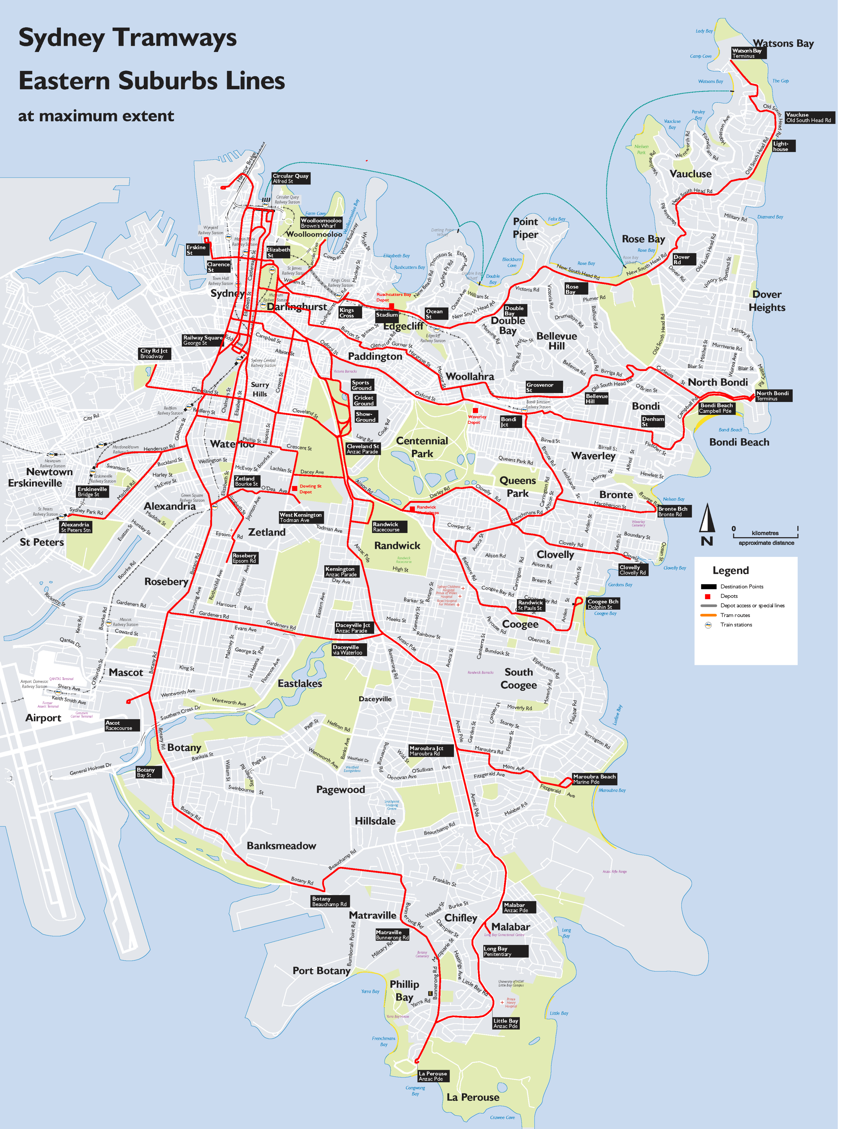
Shooting through like a Bondi Tram...
But not as thick as the successive NSW State governments that oversaw the dismantling of the tramway system, though. (OK, another cheap shot - hindsight is a wonderful thing.) As I mentioned yesterday, some parts of the network remain and are worth re-visiting, if only for the memories. So what features of the inner-west and eastern suburban tramway system can still be discerned?
Well Bondi Beach is a prime example. The trams that famously "shot through" to Bondi terminated at North Bondi where Military Road meets Campbell Parade (AKA 'Scarborough Crescent'). The terminus can still be clearly seen, as can much of the route along Campbell Pde, although cars and buses have tended to take over the trampath for parking. Interestingly, bicycle races were also held on the Campbell Parade "hot-dog", before they too were driven out by the car traffic, firstly to road races along semi-deserted Bunnerong Road and finally into the fully-enclosed Heffron Park.
The tram route to Bondi is well documented with the most interesting deviation from the obvious being where the track took a graceful curve to the right (from Bondi Rd, heading down the hill) into Denham Street, then along Fletcher and onto reserved track just past Dudley Street. (The reserved track later became Rowland Ave.) The track crossed under Wilga Street in a cutting that continued on to also pass under Bondi Road, rejoining the main drag (southern end of Campbell Parade) on the other side of Bondi Road (at the Francis Street intersection). It's hard to imagine now, but yes there was a cutting and 2 overbridges involved in keeping the track at the desired gradient, all subsequently filled in. I witnessed the start of the filling-in in the mid 1970s.
Monday, May 18, 2009
Sydney's real infrastructure debacle... ditching the extensive tram network by 1961
Why oh why did we ditch light rail? Wikipedia says this: The overcrowded and heaving trams running at a high frequency, in competition with growing private motor car and bus use, created congestion. Competition from the private car, private bus operators and the perception of traffic congestion led to the gradual closure of lines from the 1940s.
Buses, you see, were more flexible in their routing and interfered less with other vehicular traffic. Which was good in theory, but the government-run bus routes largely replicated the tram routes anyway; and as both bus and car traffic grew the road network hit its natural limit as well - stopping everything in its peak-hour tracks.
Now this infrastructure planning miracle was achieved after seeking the input of overseas "experts" and largely executed by Labor governments. Interestingly, again quoting Wikipedia, closure was supported by the NRMA, but generally went against public opinion. Thank you once again, National Roads and Motoring Association. Nothing ever really changes, does it?
All that aside, some tantalising remnants of Sydney's trams exist, to remind us of our folly. For instance there are tramway remnants along Anzac Parade, through Randwick and Kensington, including reserved track and "bus stops" facing the "wrong way" (ie towards the trams, not the buses) towards La Perouse. There is a tram bridge at Annandale and sheds at Rozelle, Tempe and Newtown, plus recycled tram depots like Randwick bus workshops and a shopping centre at North Sydney. And plenty more, if you look closely enough.
Sunday, April 5, 2009
Short Sandringham Rose Bay
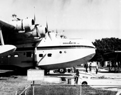
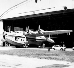
There were 2 of these 'boats (used on the run to Lord Howe Island):
(1) 'BRC had the rounded nose of a more 'pure' Sandringham (even though it was a converted Sunderland) and was called 'Beachcomber', becoming N158C with Antilles Airboats in 1974. 'BRC is now landlocked, at Southampton, UK.
(2) 'BRF, named 'Islander', was a 'near-converted' Sunderland with a blunter nose. It's now landlocked at Miami, Florida.
I may not have taken this shot - I took a lot, but so did my late friend James Davidson, who had access to the Rose Bay base via his flight engineer father. James got me hooked onto black and white photography in the first place.
Friday, March 27, 2009
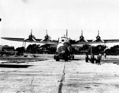
Last one for now - Short Sandringham at Rose Bay
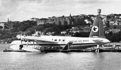
This Ansett service was to Lord Howe Island, ending in late '74 when a 'conventional' runway came into service on the island. Apart from Rose Bay there was also a major RAAF flying boat base at Rathmines on Lake Macquarie, less than 100 nautical miles north. International flights in the flying boat era also regularly touched down at such exotic locales as the Clarence River at Grafton...
- Interesting and relevant site: http://www.airwaysmuseum.com/
- "Golden Age of Flying Boats"
- RAAF Rathmines - flying boats on Lake Macquarie
- One of my Rose Bay posts
- Short Sandringham at Rose Bay
- Another Short Sandringham shot!
- Another post by me
- And my Flickr images of the Rose Bay site.
- Or here is an updated list of Sydney's airports.
Short Sandringham at Rose Bay
- Interesting and relevant site: http://www.airwaysmuseum.com/
- "Golden Age of Flying Boats"
- RAAF Rathmines - flying boats on Lake Macquarie
- One of my Rose Bay posts
- Short Sandringham at Rose Bay
- Another Short Sandringham shot!
- Another post by me
- And my Flickr images of the Rose Bay site.
- Or here is an updated list of Sydney's airports.
Short Sandringham at Rose Bay, 1974
There were just 2 of these 'boats left in the end, plying the well-worn path to Lord Howe Island:
(1) 'BRC had the rounded nose of a more 'pure' Sandringham (even though it was a converted Sunderland) and was called 'Beachcomber', becoming N158C with Antilles Airboats in 1974. 'BRC is now landlocked, at Southampton, UK.
(2) 'BRF, named 'Islander', was a 'near-converted' Sunderland with a blunter nose. It's now landlocked at Miami, Florida.
I may not have taken this shot - I took a lot, but so did my late friend James Davidson, who had access to the Rose Bay base via his flight engineer father. James got me hooked onto black and white photography in the first place.
- Interesting and relevant site: http://www.airwaysmuseum.com/
- "Golden Age of Flying Boats"
- RAAF Rathmines - flying boats on Lake Macquarie
- One of my Rose Bay posts
- Short Sandringham at Rose Bay
- Another Short Sandringham shot!
- Another post by me
- And my Flickr images of the Rose Bay site.
- Or here is an updated list of Sydney's airports.
Thursday, January 29, 2009
The Richmond line
Many years ago when I was much younger Richmond was steam operated - we are talking the late 60's into the early 1970s, but now it is electrified.
Here are some more details and links related to closed lines in Sydney:
- Richmond-Kurrajong line history in detail
- Pics and brief history
- Yet more - the stations on the Richmond line
- Parramatta to Castle Hill line, extended to Rogan's Hill
- Mortuary line to Woronora
- Mortuary line to Rookwood
- The military/industrial line to Rope's Creek
- The Sandown line
- The Warwick Farm line
- Prospect quarry line
- Potts Hill line
- North Sydney car sidings
- Holsworthy line
- Still running but with the odd closed station, the Carlingford line
- Campsie to Flemington goods line
- Homebush Abattoir branch line
- A lost station at Parramatta Park
Prospect Quarry
The railway gets a mention: "The remnant railway embankment represents a particular period in the life of the quarry and as such has historic value that should be included as part of the site interpretation. The alignment of the original branch railway should be identified and marked out, where this is feasible within the proposed development, so that this aspect of the quarry’s history is not lost. If not feasible it could be incorporated into an interpretive display panel." Let's hope that happens.
Boral (the landowner) also has an interesting historical article on the local area. The railway and the quarry get a mention:
"The subject site was originally part of the 500 acre land grant made to the
explorer William Lawson, who built his home Veteran Hall (now an identified
archaeological site on the SHR), to the west of Prospect Hill. In 1846 William
Lawson’s third son, Nelson Simmons Lawson, developed the property as the
Greystanes Estate; the name derived from the grey colour of the basalt
outcrops on the Hill, and built “Greystanes House” to the east of Prospect
Hill. Greystanes was approached by a long drive lined with a mix of English
trees and jacarandas. The house was demolished in 1946 after having fallen
into a state of disrepair (Pollen, 1988: 210)."
Greystanes is of course a local suburb, to the east of the site. The article continues:
"The quarry was formally established in 1870 and soon after was identified as
having the potential to be the principal supplier of basalt rock for metal
production in western Sydney.
"In 1910 a branch railway line was added, connecting the site with the Prospect
line. The Prospect line was constructed in 1901 by the Emu Gravel Company,
it ran for a total of 5.2km on a standard gauge. The original line not only
carried gravel from the site but also carried workers to the quarry until the
line closed in 1926. Evidence exists that this line was used for picnic outings,
where families were taken for a day out. A part of the railway embankment,
is still discernible within Prospect Quarry."
Now I'm a bit confused here. Although it seems logical (by proximity) to connect to the neighbouring private railway to Toongabbie, I always believed the Widemere line ran independently from the quarry to Fairfield, not Toongabbie. Certainly the graceful curve of the local street layout partially supports that idea, at least to Hassall Street. More investigation needed, I suspect! Back to the article:
"Construction of Prospect Reservoir began in 1882, as an important element of
the Upper Nepean Scheme, and was the main storage reservoir of Sydney's
fourth water supply system. The water from Prospect Reservoir travelled to
Pipehead Guildford via the Lower Canal, which is south of the Quarry, and to
the immediate north of Widemere East. The western boundary of the quarry
is shared with the Prospect Reservoir which contains several elements in close
proximity to this shared boundary including the outlet/scour tunnel, the
Lower Valve House, the receiving basin and the initial section of the Lower
Canal and the former inlet for 30 inch by-pass. None of these items are visible
from the quarry site.
"The landscape of Prospect Hill on Greystanes Estate has been significantly
altered from its original form. Early grazing practices cleared the entire hill,
as shown in a photograph taken in 1927 (Wallace 1992:2). Quarrying in the
area began in the 1820s, and by the latter part of the century dolorite was
being extracted from Lawson’s estate on the west and north sides of the Hill."
That's another story - the Sydney water supply!