Sydney has suffered many planning misfortunes and missteps, including the lack of a heavy rail connection to the northern beaches, despite long-standing plans to do so, and the seemingly endless indecision over the location of a "second" major airport (although some may argue that Bankstown airport already fills that role). My personal favourite though would have to be the dismantling of what was the 2nd-most extensive tram system in the British Commonwealth - second only to the London network and many times larger that Melbourne's. This startling removal of track, electric catenary and associated tram sheds was largely "achieved" by 1961. Tracks were ripped up or submerged under tar; tramcars were sold for scrap or burned; and land and buildings were reused as bus depots or sold.
Why oh why did we ditch light rail? Wikipedia says this: The overcrowded and heaving trams running at a high frequency, in competition with growing private motor car and bus use, created congestion. Competition from the private car, private bus operators and the perception of traffic congestion led to the gradual closure of lines from the 1940s.
Buses, you see, were more flexible in their routing and interfered less with other vehicular traffic. Which was good in theory, but the government-run bus routes largely replicated the tram routes anyway; and as both bus and car traffic grew the road network hit its natural limit as well - stopping everything in its peak-hour tracks.
Now this infrastructure planning miracle was achieved after seeking the input of overseas "experts" and largely executed by Labor governments. Interestingly, again quoting Wikipedia, closure was supported by the NRMA, but generally went against public opinion. Thank you once again, National Roads and Motoring Association. Nothing ever really changes, does it?
All that aside, some tantalising remnants of Sydney's trams exist, to remind us of our folly. For instance there are tramway remnants along Anzac Parade, through Randwick and Kensington, including reserved track and "bus stops" facing the "wrong way" (ie towards the trams, not the buses) towards La Perouse. There is a tram bridge at Annandale and sheds at Rozelle, Tempe and Newtown, plus recycled tram depots like Randwick bus workshops and a shopping centre at North Sydney. And plenty more, if you look closely enough.
Monday, May 18, 2009


Sunday, April 5, 2009
Short Sandringham Rose Bay
Another load of old airliners... all in Sydney during the early to mid 1970s. This is one of 2 ex-Ansett Sandringhams prior to handover to Antilles Airboats in late 1974.
There were 2 of these 'boats (used on the run to Lord Howe Island):
(1) 'BRC had the rounded nose of a more 'pure' Sandringham (even though it was a converted Sunderland) and was called 'Beachcomber', becoming N158C with Antilles Airboats in 1974. 'BRC is now landlocked, at Southampton, UK.
(2) 'BRF, named 'Islander', was a 'near-converted' Sunderland with a blunter nose. It's now landlocked at Miami, Florida.
I may not have taken this shot - I took a lot, but so did my late friend James Davidson, who had access to the Rose Bay base via his flight engineer father. James got me hooked onto black and white photography in the first place.
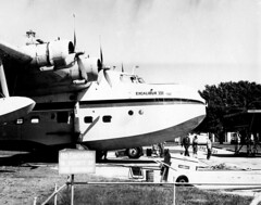
There were 2 of these 'boats (used on the run to Lord Howe Island):
(1) 'BRC had the rounded nose of a more 'pure' Sandringham (even though it was a converted Sunderland) and was called 'Beachcomber', becoming N158C with Antilles Airboats in 1974. 'BRC is now landlocked, at Southampton, UK.
(2) 'BRF, named 'Islander', was a 'near-converted' Sunderland with a blunter nose. It's now landlocked at Miami, Florida.
I may not have taken this shot - I took a lot, but so did my late friend James Davidson, who had access to the Rose Bay base via his flight engineer father. James got me hooked onto black and white photography in the first place.
Friday, March 27, 2009
Last one for now - Short Sandringham at Rose Bay
This is one of those "things" that I would guess most Sydney-siders wouldn't know - that Rose Bay was once Australia's primary airport for international travel. For many decades the most comfortable - and the safest - way to fly across oceans was via these big boats, or ones much like them. QANTAS, TEAL, Imperial Airways, Pan American: you name it, they relied on big flying boats to do the really long haul flights across water.
This Ansett service was to Lord Howe Island, ending in late '74 when a 'conventional' runway came into service on the island. Apart from Rose Bay there was also a major RAAF flying boat base at Rathmines on Lake Macquarie, less than 100 nautical miles north. International flights in the flying boat era also regularly touched down at such exotic locales as the Clarence River at Grafton...
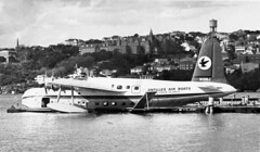
This Ansett service was to Lord Howe Island, ending in late '74 when a 'conventional' runway came into service on the island. Apart from Rose Bay there was also a major RAAF flying boat base at Rathmines on Lake Macquarie, less than 100 nautical miles north. International flights in the flying boat era also regularly touched down at such exotic locales as the Clarence River at Grafton...
- Interesting and relevant site: http://www.airwaysmuseum.com/
- "Golden Age of Flying Boats"
- RAAF Rathmines - flying boats on Lake Macquarie
- One of my Rose Bay posts
- Short Sandringham at Rose Bay
- Another Short Sandringham shot!
- Another post by me
- And my Flickr images of the Rose Bay site.
- Or here is an updated list of Sydney's airports.
Short Sandringham at Rose Bay
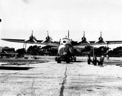
Another shot of what looks like Islander, on the hard-standing at what was once Australia's primary International Airport - Rose Bay, Sydney.
- Interesting and relevant site: http://www.airwaysmuseum.com/
- "Golden Age of Flying Boats"
- RAAF Rathmines - flying boats on Lake Macquarie
- One of my Rose Bay posts
- Short Sandringham at Rose Bay
- Another Short Sandringham shot!
- Another post by me
- And my Flickr images of the Rose Bay site.
- Or here is an updated list of Sydney's airports.
Short Sandringham at Rose Bay, 1974
This is one of 2 ex-Ansett Sandringhams prior to handover to Antilles Airboats in late 1974.
There were just 2 of these 'boats left in the end, plying the well-worn path to Lord Howe Island:
(1) 'BRC had the rounded nose of a more 'pure' Sandringham (even though it was a converted Sunderland) and was called 'Beachcomber', becoming N158C with Antilles Airboats in 1974. 'BRC is now landlocked, at Southampton, UK.
(2) 'BRF, named 'Islander', was a 'near-converted' Sunderland with a blunter nose. It's now landlocked at Miami, Florida.
I may not have taken this shot - I took a lot, but so did my late friend James Davidson, who had access to the Rose Bay base via his flight engineer father. James got me hooked onto black and white photography in the first place.
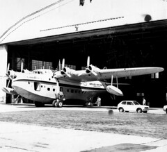
There were just 2 of these 'boats left in the end, plying the well-worn path to Lord Howe Island:
(1) 'BRC had the rounded nose of a more 'pure' Sandringham (even though it was a converted Sunderland) and was called 'Beachcomber', becoming N158C with Antilles Airboats in 1974. 'BRC is now landlocked, at Southampton, UK.
(2) 'BRF, named 'Islander', was a 'near-converted' Sunderland with a blunter nose. It's now landlocked at Miami, Florida.
I may not have taken this shot - I took a lot, but so did my late friend James Davidson, who had access to the Rose Bay base via his flight engineer father. James got me hooked onto black and white photography in the first place.
- Interesting and relevant site: http://www.airwaysmuseum.com/
- "Golden Age of Flying Boats"
- RAAF Rathmines - flying boats on Lake Macquarie
- One of my Rose Bay posts
- Short Sandringham at Rose Bay
- Another Short Sandringham shot!
- Another post by me
- And my Flickr images of the Rose Bay site.
- Or here is an updated list of Sydney's airports.
Thursday, January 29, 2009
The Richmond line
I mentioned the Richmond line a moment ago. It's still a lovely single track line for the most part with a country air about it. It ends abruptly, like it was cut short - as indeed it was. You can still see where the tracks once went on, crossed the road and went through the park. You can see remains of reserved track and old bridges alongside the main road.
Many years ago when I was much younger Richmond was steam operated - we are talking the late 60's into the early 1970s, but now it is electrified.
Here are some more details and links related to closed lines in Sydney:
Many years ago when I was much younger Richmond was steam operated - we are talking the late 60's into the early 1970s, but now it is electrified.
Here are some more details and links related to closed lines in Sydney:
- Richmond-Kurrajong line history in detail
- Pics and brief history
- Yet more - the stations on the Richmond line
- Parramatta to Castle Hill line, extended to Rogan's Hill
- Mortuary line to Woronora
- Mortuary line to Rookwood
- The military/industrial line to Rope's Creek
- The Sandown line
- The Warwick Farm line
- Prospect quarry line
- Potts Hill line
- North Sydney car sidings
- Holsworthy line
- Still running but with the odd closed station, the Carlingford line
- Campsie to Flemington goods line
- Homebush Abattoir branch line
- A lost station at Parramatta Park
Prospect Quarry
I mentioned the private railway to the Prospect quarry, well here's the current owner's heritage report on the site.
The railway gets a mention: "The remnant railway embankment represents a particular period in the life of the quarry and as such has historic value that should be included as part of the site interpretation. The alignment of the original branch railway should be identified and marked out, where this is feasible within the proposed development, so that this aspect of the quarry’s history is not lost. If not feasible it could be incorporated into an interpretive display panel." Let's hope that happens.
Boral (the landowner) also has an interesting historical article on the local area. The railway and the quarry get a mention:
"The subject site was originally part of the 500 acre land grant made to the
explorer William Lawson, who built his home Veteran Hall (now an identified
archaeological site on the SHR), to the west of Prospect Hill. In 1846 William
Lawson’s third son, Nelson Simmons Lawson, developed the property as the
Greystanes Estate; the name derived from the grey colour of the basalt
outcrops on the Hill, and built “Greystanes House” to the east of Prospect
Hill. Greystanes was approached by a long drive lined with a mix of English
trees and jacarandas. The house was demolished in 1946 after having fallen
into a state of disrepair (Pollen, 1988: 210)."
Greystanes is of course a local suburb, to the east of the site. The article continues:
"The quarry was formally established in 1870 and soon after was identified as
having the potential to be the principal supplier of basalt rock for metal
production in western Sydney.
"In 1910 a branch railway line was added, connecting the site with the Prospect
line. The Prospect line was constructed in 1901 by the Emu Gravel Company,
it ran for a total of 5.2km on a standard gauge. The original line not only
carried gravel from the site but also carried workers to the quarry until the
line closed in 1926. Evidence exists that this line was used for picnic outings,
where families were taken for a day out. A part of the railway embankment,
is still discernible within Prospect Quarry."
Now I'm a bit confused here. Although it seems logical (by proximity) to connect to the neighbouring private railway to Toongabbie, I always believed the Widemere line ran independently from the quarry to Fairfield, not Toongabbie. Certainly the graceful curve of the local street layout partially supports that idea, at least to Hassall Street. More investigation needed, I suspect! Back to the article:
"Construction of Prospect Reservoir began in 1882, as an important element of
the Upper Nepean Scheme, and was the main storage reservoir of Sydney's
fourth water supply system. The water from Prospect Reservoir travelled to
Pipehead Guildford via the Lower Canal, which is south of the Quarry, and to
the immediate north of Widemere East. The western boundary of the quarry
is shared with the Prospect Reservoir which contains several elements in close
proximity to this shared boundary including the outlet/scour tunnel, the
Lower Valve House, the receiving basin and the initial section of the Lower
Canal and the former inlet for 30 inch by-pass. None of these items are visible
from the quarry site.
"The landscape of Prospect Hill on Greystanes Estate has been significantly
altered from its original form. Early grazing practices cleared the entire hill,
as shown in a photograph taken in 1927 (Wallace 1992:2). Quarrying in the
area began in the 1820s, and by the latter part of the century dolorite was
being extracted from Lawson’s estate on the west and north sides of the Hill."
That's another story - the Sydney water supply!
The railway gets a mention: "The remnant railway embankment represents a particular period in the life of the quarry and as such has historic value that should be included as part of the site interpretation. The alignment of the original branch railway should be identified and marked out, where this is feasible within the proposed development, so that this aspect of the quarry’s history is not lost. If not feasible it could be incorporated into an interpretive display panel." Let's hope that happens.
Boral (the landowner) also has an interesting historical article on the local area. The railway and the quarry get a mention:
"The subject site was originally part of the 500 acre land grant made to the
explorer William Lawson, who built his home Veteran Hall (now an identified
archaeological site on the SHR), to the west of Prospect Hill. In 1846 William
Lawson’s third son, Nelson Simmons Lawson, developed the property as the
Greystanes Estate; the name derived from the grey colour of the basalt
outcrops on the Hill, and built “Greystanes House” to the east of Prospect
Hill. Greystanes was approached by a long drive lined with a mix of English
trees and jacarandas. The house was demolished in 1946 after having fallen
into a state of disrepair (Pollen, 1988: 210)."
Greystanes is of course a local suburb, to the east of the site. The article continues:
"The quarry was formally established in 1870 and soon after was identified as
having the potential to be the principal supplier of basalt rock for metal
production in western Sydney.
"In 1910 a branch railway line was added, connecting the site with the Prospect
line. The Prospect line was constructed in 1901 by the Emu Gravel Company,
it ran for a total of 5.2km on a standard gauge. The original line not only
carried gravel from the site but also carried workers to the quarry until the
line closed in 1926. Evidence exists that this line was used for picnic outings,
where families were taken for a day out. A part of the railway embankment,
is still discernible within Prospect Quarry."
Now I'm a bit confused here. Although it seems logical (by proximity) to connect to the neighbouring private railway to Toongabbie, I always believed the Widemere line ran independently from the quarry to Fairfield, not Toongabbie. Certainly the graceful curve of the local street layout partially supports that idea, at least to Hassall Street. More investigation needed, I suspect! Back to the article:
"Construction of Prospect Reservoir began in 1882, as an important element of
the Upper Nepean Scheme, and was the main storage reservoir of Sydney's
fourth water supply system. The water from Prospect Reservoir travelled to
Pipehead Guildford via the Lower Canal, which is south of the Quarry, and to
the immediate north of Widemere East. The western boundary of the quarry
is shared with the Prospect Reservoir which contains several elements in close
proximity to this shared boundary including the outlet/scour tunnel, the
Lower Valve House, the receiving basin and the initial section of the Lower
Canal and the former inlet for 30 inch by-pass. None of these items are visible
from the quarry site.
"The landscape of Prospect Hill on Greystanes Estate has been significantly
altered from its original form. Early grazing practices cleared the entire hill,
as shown in a photograph taken in 1927 (Wallace 1992:2). Quarrying in the
area began in the 1820s, and by the latter part of the century dolorite was
being extracted from Lawson’s estate on the west and north sides of the Hill."
That's another story - the Sydney water supply!
My list of Sydney's race tracks and circuits.
or checkout my list of Sydney and surrounding airstrips and airports.
Wednesday, January 28, 2009
Things I plan to do...
Well I plan to do a lot of things, whether I find the time is another matter..
- I plan to look at disused, discarded or removed railway lines in Sydney (here's a short list: The line from Richmond across the Nepean and up the mountains; the line from Campbelltown to Camden; the Toongabbie private line to the Associated Blue Metal Company quarry near the CSIRO's sheep research station at Prospect that survives as an embankment in a field; Widemere, same area but servicing the Sydney and Suburban Blue Metal Quarry Ltd, running from the south eastern side of Prospect Reservoir down to the main railway at Fairfield; and the private zig zag railway at Thornleigh)
- "Old" roads, like Old Cowpasture Road, now mostly known as the Horsley Drive
- Disused ferry crossings, like the Georges River crossing at the southern end of Forest Road - still largely intact. Or the ferrymasters' cottage and remains of the punt infrastructure at the Punt Bridge, East Gosford
- The remains of old bridges, like the original Iron Cove Bridge at Gladesville, still clearly visible, or the burnt out remains of the Lane Cove River Bridge at North Ryde; the original low-level Roseville Bridge, of which the snaking approach roads tell the tale
- Old tram routes, especially the steam trams such as the line to Parramatta from Castle Hill, or from Redbank Wharf
- And anything else I stumble over.
Saturday, November 15, 2008
Sydney AP Tower overview
I'm not sure where Tower number 1 was, but I guess it was fairly close to Tower 2. Tower 2 became quite substantial over time and morphed into the TAA and East West Airlines terminal by the 1970s. It's still there, embedded into the Qantas domestic terminal.
Tower 3 is also still there, near the intersection of 16/34 and 07/25, and is a fire station.
Tower 4 is still there, near the (relocated) Cooks River mouth.
And Tower 5 is the active current tower.
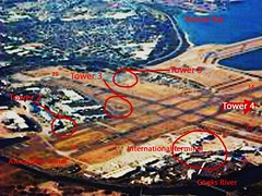
Tower 3 is also still there, near the intersection of 16/34 and 07/25, and is a fire station.
Tower 4 is still there, near the (relocated) Cooks River mouth.
And Tower 5 is the active current tower.
Friday, November 14, 2008
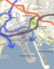
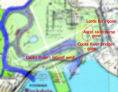
Sydney Airport - Part 6 - Cooks River 2008 vs 1940
History of Sydney Airport in pictures, number 6 in the series. This overview shows the lot. We have the old river course (dotted blue) and the new (solid blue). The original railway is dotted orange and the deviated line is solid. The original Cooks River bridge and associated roadway to Kyeemagh (including Lord's Rd) is dotted purple, the current motorway solid. Ascot Racecourse is in yellow. You can see all of the current runways and how they are placed against these changes.
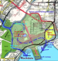
Sydney Airport - Part 5 - Cooks River 1966 vs 1940
History of Sydney Airport in pictures, number 5 in the series. In this overview of changes apparent between 1940 and 1966 we see the Botany Goods Railway deviation (red line, original route dotted) and the Cooks River in its original course (dotted blue) and altered course (solid blue). Ascot racecourse is shown in yellow but was of course closed and overlaid in the mid-50s by the 07/25 runway, shown here faintly in pink.
Also shown in pink is the slightly-extended 16/34 runway, yet to be taken fully out into the bay. That extension as shown caused General Holmes Drive to be laid into a cutting where it went under the runway. General Holmes Drive (in solid black) replaced the Lords Road/Government Rd combination (dotted black) that was also cut in the mid-50s by the east-west runway.
The International or Overseas terminal was still sited at Lauriston Park, near the TAA terminal (later to become Australian Airlines and then Qantas domestic).
Also shown in pink is the slightly-extended 16/34 runway, yet to be taken fully out into the bay. That extension as shown caused General Holmes Drive to be laid into a cutting where it went under the runway. General Holmes Drive (in solid black) replaced the Lords Road/Government Rd combination (dotted black) that was also cut in the mid-50s by the east-west runway.
The International or Overseas terminal was still sited at Lauriston Park, near the TAA terminal (later to become Australian Airlines and then Qantas domestic).
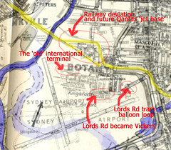
Sydney Airport - part 3- 1954 vs 1965
History of Sydney Airport in pictures, number 3. Some detail that appears when you compare a 1954 map with a '65 one. You can see that the new runways - short 16/34 and main 07/25 are in place and the remaining roadways renamed. There's a tram balloon loop on Lords Road in 1954 that used to serve the Ascot racecourse. The railway has deviated to the north, leaving room for Qantas to expand.
Sydney Airport - Part 4 - 1966 vs 1940
History of Sydney Airport in pictures, number 4. Big changes. Cooks River was shifted west, with the roadway to Kyeemagh largely removed or relocated. Polo and cricket grounds and the golf links to the west and south were also removed or relocated. Ascot Racecourse was absorbed.
Sydney Airport - part 2 - 1940 vs 1954
My potted history of Sydney Airport in pictures, part 2. Comparing and contrasting street directories by Premier, Robinson and Gregory's, here we are looking at what happened between 1940 and 1954. Please forgive me if you disagree, oh map-makers and publishers, but I think this is "fair use" - or re-use - of your art.
Starting from the north, Ricketty Street bridge is just such a great name that I have to include it. It spans one of only 3 industrial canals in Australia, and is still worth a visit today.
The original goods railway line is shown in yellow, with the northward diversion in pink and orange. I have shown where the suburb of Lauriston Park was, and Ascot racecourse in relation to the concrete (main) east-west runway (in pink) that was laid by 1954. To build that and the new but then-shorter north-south runway involved diverting and filling the course of the Cooks River (in blue). That was quite a project. Imagine trying to move a river now - you'd need to be pretty sure about how the changes would impact the local ecology, for starters.
Anyway, the Bonnie Doon Golf links in the north-west corner were replaced with what later became the International terminal and the cargo precinct. More recreation grounds were lost - a polo field, a cricket ground and another golf links to the south. And the main runway now ended where Ascot racecourse was in 1940. Muddy creek was also shortened in the whole process of moving the Cooks River.
The dotted black line shows the new General Holmes Drive, replacing the old road, the bridge and Government Rd, all marked in brown. Some residences were left stranded by these changes, particularly those near the southern end of the short 16/34 runway. These houses were "on" General Holmes Drive until the mid-1960s, when the road was diverted into a cutting to the south and bridged-over with the extended north/south runway.

Starting from the north, Ricketty Street bridge is just such a great name that I have to include it. It spans one of only 3 industrial canals in Australia, and is still worth a visit today.
The original goods railway line is shown in yellow, with the northward diversion in pink and orange. I have shown where the suburb of Lauriston Park was, and Ascot racecourse in relation to the concrete (main) east-west runway (in pink) that was laid by 1954. To build that and the new but then-shorter north-south runway involved diverting and filling the course of the Cooks River (in blue). That was quite a project. Imagine trying to move a river now - you'd need to be pretty sure about how the changes would impact the local ecology, for starters.
Anyway, the Bonnie Doon Golf links in the north-west corner were replaced with what later became the International terminal and the cargo precinct. More recreation grounds were lost - a polo field, a cricket ground and another golf links to the south. And the main runway now ended where Ascot racecourse was in 1940. Muddy creek was also shortened in the whole process of moving the Cooks River.
The dotted black line shows the new General Holmes Drive, replacing the old road, the bridge and Government Rd, all marked in brown. Some residences were left stranded by these changes, particularly those near the southern end of the short 16/34 runway. These houses were "on" General Holmes Drive until the mid-1960s, when the road was diverted into a cutting to the south and bridged-over with the extended north/south runway.
Sydney Airport - part 1 - 1926 vs 1940
I think it's extraordinary what we did to create Sydney Airport at Mascot and it's worth revisiting the story occasionally to remind ourselves of both what we have created and what we have lost.
Thus begins my potted history of Sydney Airport, in pictures. It really started in the early 1920s with Nigel Love leasing land from the Ascot Racecourse and Recreation club, to the west of the racecourse, immediately west of the suburb of Lauriston Park, shaded green here. It was flat but boggy ground, bordered by Shea's Creek to the west and Cook's River to the south.
I have shaded the Ascot track in blue. It's shown on both the 1926 and 1940 Premier and Robinson street directories, but disappears by the 1950s. That racecourse area became, variously, vacant land to the east of the threshold of runway 07/25; the Flight Facilities or GA area to the northeast; the east-west runway threshold itself; and what is now long-term parking. You can see that Lord's Rd and the Cooks River bridge (in yellow) were still around in 1940, but disappeared when the river was diverted and the new concrete runways built (in the mid-1950s).
To the north is the Botany Goods Railway. You can see it is a straight line here, both in 1926 and 1940, but was later diverted to the north. Grass and gravel runways pointed roughly north-east to the south-west, and east-west during this period. The northeast threshold was cut by the railway line and one incident occurred when a DC3 collided famously with a goods train!
The streets to the north were subsumed into the airport after the railway diversion, later becoming part of what Qantas called its "Jet Base" with the advent of the 707. To the south are recreation grounds.

Thus begins my potted history of Sydney Airport, in pictures. It really started in the early 1920s with Nigel Love leasing land from the Ascot Racecourse and Recreation club, to the west of the racecourse, immediately west of the suburb of Lauriston Park, shaded green here. It was flat but boggy ground, bordered by Shea's Creek to the west and Cook's River to the south.
I have shaded the Ascot track in blue. It's shown on both the 1926 and 1940 Premier and Robinson street directories, but disappears by the 1950s. That racecourse area became, variously, vacant land to the east of the threshold of runway 07/25; the Flight Facilities or GA area to the northeast; the east-west runway threshold itself; and what is now long-term parking. You can see that Lord's Rd and the Cooks River bridge (in yellow) were still around in 1940, but disappeared when the river was diverted and the new concrete runways built (in the mid-1950s).
To the north is the Botany Goods Railway. You can see it is a straight line here, both in 1926 and 1940, but was later diverted to the north. Grass and gravel runways pointed roughly north-east to the south-west, and east-west during this period. The northeast threshold was cut by the railway line and one incident occurred when a DC3 collided famously with a goods train!
The streets to the north were subsumed into the airport after the railway diversion, later becoming part of what Qantas called its "Jet Base" with the advent of the 707. To the south are recreation grounds.
Thursday, September 11, 2008
Sydney AP Tower c1930s
Sydney Airport goes back a long way, like aviation in Australia in general. Whilst early aviators tended to fly out of Penrith, Parramatta or Richmond (Clarendon) at first, a site closer to Sydney itself was selected near the Ascot race course, on flat marshland adjoining the Cooks River. To the east was extensive swampland and a mill, to the north was a brickworks. To the west was market gardens. To the south was the river, more swamp and Botany Bay, of course.
I'm unsure exactly when this tower was built but sometime in the 1930s would be close.

I'm unsure exactly when this tower was built but sometime in the 1930s would be close.
Friday, July 25, 2008
The ramp from bridge to tunnel

The Sydney Harbour bridge carries train (and bicycle) traffic on its western side. This is a shot of a mixed suburban electric set on the ramp from bridge to tunnel, just short of the tunnel itself. Next stop Wynyard station.
What is less well known is that the eastern side was designed for the same purpose, but for a heavy rail line that was never built. The line would have gone from Wynyard to the northern beaches, however the tide of public opinion (or perhaps political will) turned against infrastructure investment and plans for the line were filed away. However a somewhat less costly option was taken up: trams. As Sydney had an extensive tramway network on both sides of the harbour, it made sense to connect the 2 'halves' as it were and thereby avoid avoid maintenance facility duplication, tram/rail interchanges or even truck transport, whilst also providing a service to commuters.
Of course this impacted ferry use, but not as much as a heavy rail line would have. Manly's tram network was an isolated one, cut at the Spit, so whilst some commuters would not mind a short (mostly covered) walk over the Spit bridge, many more would still choose the ferry.
So the compromise bought a cheaper but less useful light-rail line but at the price of a 'proper' straight-through heavy rail line. A compromise that may still have paid dividends today, except we tore up the tram system by 1961. Which leaves us with buses and extra roadlanes on the bridge.
The tramline (whilst it lasted) paralleled the rail in many ways, with a tunnel to platforms at Wynyard (now deserted and partially used as car parking), a station at the Milson's Point side and a flyover bridge to North Sydney. The approach to that bridge is used (again) as car parking .
Thursday, July 24, 2008
Honey, I've shrunk the tram network

Oops. We lost a few lines between 1921 and 1950. Still, it's better than what we ended up with after 1961 - ie nothing. (Nothing but buses, anyway.)
So what disappeared? The Manly line went. Narrabeen went as well. Parramatta to Rosehill and Parramatta to Castle Hill, gone. Sutherland to Cronulla, gone. Kogarah to Sans Souci, gone. Rockdale to Brighton, gone.
And then in 1961 we pulled the plug on the whole Sydney system.
Whilst we may blame our current governments for lack of investment in public infrastructure we must remember that this "trend" really dates back some 50 years or more. And it's hard to turn these things around.
So how did it happen? After the mad rush to build infrastucture and create a backbone for Sydney's development a few sums were quietly done. Whilst many tram lines were opened to win political favour as well as to profit developers, the actual patronage revealed was quite poor on the outer lines, whilst costs were absurdly high. These outer suburban lines were also isolated from the main network or were using outdated technology. So the low-hanging fruit (as we say) was plucked - the worst returns in the least politically sensitive areas went first. Light and heavy rail plans were quietly scrapped (like heavy rail to the northern beaches), scaled back or slowed down (like the eastern suburbs railway) and investment switched to cheaper, more flexible but oil-dependent buses instead.
Of course buses use roads, and cars also need roads. So it all seemed to make sense in a world of cheap oil and post-war wealth. People liked cars after all. And it benefited the increasingly important - and powerful - automobile industry. It seems amazing that the trams stopped less than 50 years ago - and that here we are now facing a growing shortage of public transport infrastructure, in a world where trams could have played a wonderfully effective role.
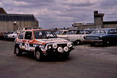
Rally cars on roof of Bankstown Square shopping centre
In the '70s we could even start car rallies from the roof of a major suburban shopping centre. Imagine that.
Did you say 'trams'? Have a look at this...

You wanna see a tram network? THIS is a tram network... alas it's all gone, bar one newish and oh-so-short light rail system that runs briefly over some of the same territory.
Subscribe to:
Posts (Atom)