Wednesday, December 3, 2014

Pitt Town satellite airstrip and Hardie Ferodo test track

Pitt Town airstrip was a WWII airfield satellite of RAAF Richmond. Satellites and dispersal strips eased capacity constraints at primary air bases and dispersed aircraft for tactical security reasons.

Can you spot the now disused strip? I had a hunch but...
Then again Airstrip Road is a bit of a giveaway...
It wasn't far from RAAF Richmond...
And it was also the site of the Hardie Ferodo test track (for vehicle brakes and components). Some club motor sport events were also held here post-war.


Postscript... I have received an email from reader Rob who has taken the trouble to sketch the runway, the test track and more (thanks Rob!).

In the image below the red line is the HF proving ground. Rob reports that it has leveled areas raised in places to keep it out of what were regular floods, presumably. The floods I remember well from my childhood. I'm sure it still happens but it used to be quite catastrophic and regular in the past, until remediation and flood management work was done. 

The blue line is the actual airstrip. Again Rob reports that the surface is still quite visible in parts as you drive along Airstrip Rd. The kink at the southern end seems there for no reason, although it presumably made sense to someone when the land was parceled up and sold off over time.

The yellow line on the western side is where there are houses/buildings now, and Rob suggests that you can see clearly the flat hard surfaces that probably were the tie-down/flight-line areas. There are also some unusual looking depressions and berms that could have been dugouts near Pitt Town/Dural Rd.

Here's Rob's sketch:


 Well worth a visit, I suspect!


Indeed why not visit the full list of Sydney's airfields and airports?

Jamison Park airfield at Penrith - or is that Belmore Park airfield - and speedway!

Penrith was a center for aviation in Sydney before Richmond (1912, or perhaps 1914) - or even Mascot (1919). This is the brief story of 3 key historic sites for aviation in the Penrith - indeed greater Sydney - region: Emu Plains and LJR Jones (1911); Bill Hart and Smith's Belmore Park speedway and aerodrome (also 1911); and Jamison Park (possibly in the 1930s).

The 'flying dentist' William Ewart Hart operated from Penrith in these early years, circa 1911 onwards, from a site known as "Belmore Park", just north of the railway line. This site later became the Penrith Speedway and - as we often do with history - is now largely buried under new development. (Another Penrith Speedway was developed by Victor Sutherland, naming it Brooklands after, umm, Brooklands.)

Indeed the Belmore Park site is regarded as the first dedicated "aerodrome" in Australia. Shame we haven't done more to recognise that as an important fact...

The first manned flight of note in the Penrith region had been completed in November 1911 with William Ewart Hart’s flight from that same Belmore Park, Penrith to Parramatta Park, Parramatta in a Bristol biplane, taking about 20mins. Hart also flew what is regarded as the longest flight at that time in the Southern Hemisphere, from Penrith to Sydney Showground. It took just 55 minutes, including a stop at St Marys.

Hart, born in Parramatta, practiced dentistry at several locations and trained as an aviator at Penrith, at the private flight school known as the Aerial League of Australia. That operation was based at Belmore Park. The Aerial League itself had been formed in 1909 by George and Florence Taylor. Their selection of Belmore Park is reputedly the first instance in Australia of a piece of ground being set aside specifically for aviation purposes: ie arguably the first 'aerodrome'. Hart himself subsequently founded an aviation school at Belmore Park in January 1912 and had intention to do the same again at Richmond that same year, but was thwarted by an accident early that year.


Interestingly, Leslie John Roberts Jones was reportedly testing his experimental (initially steam-driven!) aircraft at Emu Plains at roughly the same time. L.J.R. Jones hailed from Bathurst but his family moved to Hereford St, Glebe in Sydney. In any event Jones too played an important role in the development of manned flight in Australia, becoming well known for his engine and aircraft designs and aviation engineering expertise. Jones used a field at "Eden Glassie", Herman Hollier's property at Emu Plains to put his experimental aircraft to the test. The aircraft, having been entirely built - including engine castings - at his parent's home in Glebe, was trucked (disassembled) in one night to Emu Plains. On 4th of June 1911 his super-heated steam-engined aircraft lifted off (or perhaps hopped) for a short distance. Unfortunately the impressive but fragile machine was damaged beyond repair by bad weather. Jones went onto design and build further flying machines and in so doing carve a sizable niche in aviation history for himself.  


On the other (southern) side of the railway is Jamison Park. Originally Penrith's racecourse (dating back to the late 19th Century) this park was still noted in the 6th edition of The Premier Street Directory of Sydney, circa 1940, as "Penrith Racecourse". And of course today "Racecourse Rd" runs north-south down one side of the park. But there are few if any remaining signs of that racecourse. This document from Penrith City Council gives more detail on the racecourse and South Penrith in particular. 

The Penrith Aero Club also operated from the Jamison Park site from perhaps the early 1940s until the late 1950s. Certainly the Penrith Aero Club was known to be conducting joy flights and training from Jamison Park during the 1950s.

In 1968 the Penrith Aero Club's disused clubhouse in Jamison Park was - I believe - moved, becoming the 'N. A. Hunter Pavilion', at Howell Oval. It didn't move far, if it moved at all - it's just on the other side of Jamison Road. 

Why 2 airfields in Penrith? And why are there so many other airstrips and army camps (mostly old and forgotten) dotted around western Sydney? The western and south-western fringes of the Cumberland Plain are mostly flat and open, and at the outbreak of both world wars were sparsely settled and quite distant from the main centres of population; despite that relative isolation they mostly had good rail links to Sydney. The army for example had established a base near Liverpool and later at Ingleburn. And the Royal Australian Air Force (RAAF) selected sites nearby or in similar terrain but more suited to aviation. One other reason for "going west" was the military value of being out of range of naval bombardment. 

The Penrith area is Mulgoa peoples' land, who spoke the Darug language. Jamison Park was named for Thomas Jamison, a pioneer landowner and First Fleet surgeon. 

Selected sources:
Penrith City heritage study (1) and (2) and (3)
Thornton Hall website
More on LJR Jones
More on Penrith Speedway

Checkout my list of Sydney and surrounding airstrips and airports.  There is a discussion in the comments to that page about a possible EAA or emergency alighting area for seaplanes on the Nepean River, adjacent to Jamison Road. (Alternatively that EAA was at the more remote Nepean Dam.)


or checkout my list of Sydney and surrounding airstrips and airports.   

Monday, December 1, 2014

Bankstown Airport - Sydney's "other" second airport

Bankstown Airport, once the busiest by movements in Australia but I'm told it's just 4th now. I think they are miscounting but anyway, that's the official story. Bankstown has multi-runway parallel strips, plus some crossing (but disused). There are three main parallel east-west runways, a long centre runway for high-performance aircraft, a northern runway for arrivals and departures, and a southern runway for circuit training.

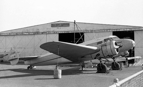
Originally planned in 1929, but not established until 1940 as an RAAF facility. Subsequently taken over by the USAAF and established as a key strategic air base to support the war effort, circa 1942. It transferred from US to British Fleet Air Arm operations in 1945, and was known as Royal Naval Air Station Bankstown, or HMS Nabberley, until handed back to the RAAF in 1946. Interestingly, several "dummy houses" were built to make Bankstown Airport appear as a farm, with disguised hangers and fake roads.

There was an underground command post on Black Charlie's Hill with gun pits located within and around the airport to protect it from air attack. Another anti-aircraft battery was situated on high land on the corner of Bexley Road and Homer Street, Clemton Park.

de Havilland and its successors have been located at this airport since 1942, occupying the area south of the main runway. RAAF Mosquito "Wooden Wonder" bombers were built there. The primary (centre) runway (11C/29C) is 1,415m x 30m, limited to 50 tonnes MTOW.

Marshall Airways and Sid Marshall's musuem was based here, too - very important information to any Sydney-born child obsessed with aviation in the late '60s and early '70s.  I undertook flying training here at Illawarra Airways, too, so it's of some personal interest. Not that I ever finished that training: I got distracted!


These days Bankstown is lumped into a commercial bundle with Camden via privatisation. That means user pays and "other use" optimisation, so - for me at least - some of the charm has gone. Again, that's life.   

Friday, November 28, 2014

Sydney Airport - Kingsford-Smith, Mascot and Ascot racecourse

Well we call it Sydney Airport but really it's just one of many in the Sydney region. It's not the largest either but it is the "international" one, of course. And the one we first think of, unless you think of Bankstown or Richmond or Camden or whatever first.

It isn't - or wasn't - the Sydney international airport at Rose Bay, of course!


That one was at Rose Bay on Sydney Harbour. 

No, we are looking a a land-based "airfield". Like Rose Bay it's historically important - not because it was Sydney's first aviation location or even "landing ground" but because it's relatively old and significant on several different levels. It has layers of history, with indigenous use, environmental importance, recreational use and major engineering works to commend it to our attention. We've even moved a river just to accommodate it.


In short, Sydney "Kingsford-Smith" Airport at Mascot is one of the oldest continually operating airports in the world. In 1919, Nigel Love's Australian Aircraft and Engineering Company leased land from the Kensington Racing Club (adjacent to Ascot racecourse) and established an aerodrome. It was, basically, a swampy paddock. A flat, swampy paddock. With Cooks River to the west, some recreational grounds and Botany Bay to the south and Eastlakes swamp to the east.


As an aside, it was H. E. Broadsmith and Nigel Love who in 1919 established Australia's aircraft manufacturing industry, forming the Australian Aircraft and Engineering Company (AAEC) to  produce 6 AVRO 504K training biplanes for the R.A.A.F. and 7 for other customers. Broadsmith determined that Mountain Ash was the best local timber for manufacture to British Aeronautical specifications.

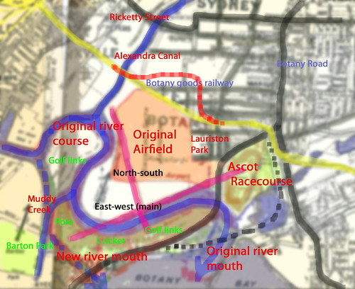
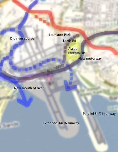
A canvas hangar was built and the first aircraft was assembled on site; the first flight taking place in November 1919 with the aforementioned Nigel Love in command. By the mid-1920s, regular air services between Sydney, Melbourne and Adelaide were underway and the Australian Federal Government had taken control of the airport. In the 1940s a passenger terminal was opened and the Cooks River diverted to allow for the construction of two new runways, including 07/25 as the "main" runway aligned east to west.


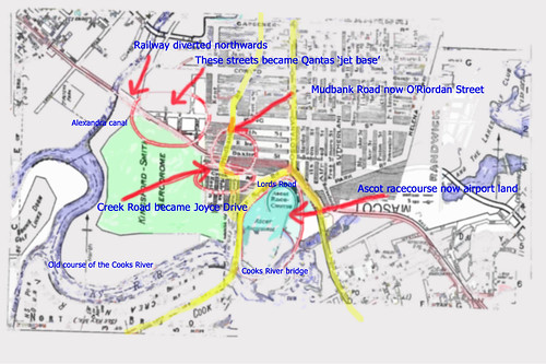
Both the suburb of "Lauriston Park" and the Ascot Racecourse, immediately to the east, were subsumed into the growing aerodrome. As shown in the map above, the main road south originally  split the racecourse and the aerodrome, with a tramline and a balloon loop to the north of the racecourse itself. As the airport grew the road south - and its bridge over the Cooks River - was diverted to the east. The Cooks River itself being diverted to the west.    

During WWII Sydney hosted No 4 EFTS at Mascot, part of the Elementary Flying Training Schools (EFTS) scheme, later to be re-dedicated to Communications.
 
In 1963 work commenced on the construction of the 34/16 runway extension southwards into Botany Bay, in preparation for larger, heavier international aircraft carrying greater fuel loads (and needing a longer runway). In 1965 work commenced on the construction of the "new" International Terminal, again in readiness for newer, larger aircraft (not that they actually expected the Boeing 747 to be quite that big.).


In 1989 a fairly close-spaced and slightly staggered parallel runway 34/16 was approved, being  completed in 1994 (making 3 operational runways).

After all of that investment the Australian Government then privatised - for better or for worse - Sydney Airport in 2002.

Not to be confused with Western Sydney Airport, not built but "planned". 

or checkout my list of Sydney and surrounding airstrips and airports

Thursday, November 27, 2014

Lost but not forgotten: RAAF Rathmines on Lake Macquarie

RAAF Rathmines on Lake Macquarie, south and west of Newcastle and north of Sydney and the Central Coast. A WWII "air base" with a difference!
The traditional inhabitants of this land were known as the Awabakal people. Awaba is the Aboriginal name for the region and Ninkinbah was the Aboriginal name for Lake Macquarie. There are several sites within Rathmines Park that demonstrate Aboriginal use of the area.

Early European settlement around Rathmines took place in the 1840's with the name of Rathmines derived from the Hely family (extensive landholders on the Central Coast) that came from a town named Rathmines, located near Dublin in Ireland. The Hely family built a homestead and farmed a significant portion of the land that now makes up Rathmines Park.

However the story of Rathmines as an air base starts when the site on the shores of Lake Macquarie was identified as a possible place for a flying boat base in 1936, after the Director of Duties, RAAF HQ Victoria Barracks, Melbourne gave instructions to investigate and recommend a site for a flying boat base in the Newcastle region. A ground and water survey of the bay and inlet was undertaken, and while the Rathmines site was the second recommendation, it was considered as the most likely site, and was chosen.

During July 1938, No 5 Squadron from RAAF Base Richmond was sent to investigate landing areas and sites around the Lake Macquarie area for the establishment of the Rathmines Base and the eventual move of the squadron. On January 1 1939, the No 5 squadron was renamed No 9 (Fleet Cooperation) Squadron. Further surveys of the area were made in August 1939, and in September camp was set up, with arrangements made to rent local cottages as living quarters. The Base became operational when the No 9 Squadron transferred from RAAF Base Point Cook to the selected 31 hectare site. 9 Squadron was initially equipped with Supermarine Seagull flying boats.

PBY-5 Catalina flying boats were next to arrive in February 1941, and by September 1943 the base comprised 14 Catalinas, two Seagulls, a Dornier Do24 and a Douglas Dolphin.

Rathmines also housed Walrus, Martin Mariner, Kingfisher and Short Sunderland and Empire flying boats. With 230 buildings and other marine facilities there were 40 aircraft and almost 3,000 RAAF personnel at the base c.1944-45. As well as being a repair, servicing and new aircraft conversion centre, it was also a base for air crew training.  A total of 168 Catalinas were flown with the RAAF, the Catalina flying boats being the only aircraft to see continuous service with the RAAF during wartime operations against Japan. Nevertheless, and somewhat sadly, in January 1952 the Catalina was declared surplus to requirements and the aircraft taken out of service.

Post-WWII Rathmines continued as a ground training base with an Officers' Training School and training facilities for senior NCOs, PT instructors and national servicemen. The operational focus shifted to "search and recovery" operations. An airstrip was also roughly built on the promontory for the sole use of the C.O.'s Auster aircaft. Seaplane operations were progressively disbanded during the 1950s.

Circa 1962 the site was sold to Lake Macquarie Council, following which many smaller buildings were purchased and removed from the base or re-purposed by the Council as, for example, local community halls. Of 230 buildings just 10 remained intact in 1998. A large seaplane/flying boat servicing hangar was also disassembled and shipped to RAAF Base Richmond to house the RAAF's initial fleet of  Lockheed C-130 Hercules aircraft.

The Rathmines base has since been heritage listed by the NSW State Government.

See also:
See also the Woy Woy/Ettalong airstrip and nearby Tuggerah airstrip (where Catalinas were reputed to do "touch and goes").

And Rose Bay Flying Boat base - Sydney's forgotten International Airport

Want even more? Here is an updated list of Sydney's airports.  
Lost airfields of the Central Coast - Woy Woy (AKA Ettalong)

Woy Woy Aerodrome was constructed in 1942 as a 'dispersal' airstrip for the Fleet Air Arm of the Royal Navy. The airfield was built as a satellite of Schofields.


The airstrip ran north to south next to what is now Trafalgar Avenue, Woy Woy. It was constructed from compacted red gravel. The red gravel may still be seen (if you look hard enough) along the edge of the road surface in some places. As Trafalgar Avenue has a slight bend at the northern end it's unclear to me exactly what the alignment was, however it was of a substantial length roughly parallel with current day Trafalgar Ave. 

The hangars and service area were located in what is now Alma Avenue. Some hangars or support may still be in existence, perhaps much modified, used as warehouses or other industrial buildings.
I have looked at these building but without looking inside and out the back it's hard to be certain of their vintage.

The airfield was last used in 1946 and officially closed by 1950; the land subsequently developed for residences. A last-ditch stand was made to preserve both this strip and Tuggerah to the north as emergency landing fields between Sydney and Brisbane but as the reliability of commercial aircraft improved the need for such airfields declined. An anti-aircraft battery protected the airfield, located in Blackwall Mountain Reserve to the north and east of the strip.

From time to time artifacts, including aero engines and drop tanks have been found discarded and buried alongside the strip. More details may be found on Steve's All things Woy blog and a reworded version with slight differences here and a crash landing in 1950.

Another post by me on this strip.

Want even more? Here is an updated list of Sydney's airports.   
Wednesday, November 26, 2014

The Oaks aerodrome, a WWII satellite nestled against the mountains

The Oaks 'dispersal' airstrip, another WWII runway, as per Menangle and several others.
The image above shows what I presume to be the WWII runway alignments, as shown on a recent Google Map. The green alignment is "certain" based on what is visible and recorded elsewhere, however the shorter yellow alignment is probably only a recent development post-WWII. 

The Oaks airfield was constructed circa 1942 as a satellite aerodrome to RAAF Camden. There was a 5000 foot x 150 foot sealed runway aligned 36/18 and split by Burragorang Road (complete with gates to stop stray cars!). Operations probably included Hudsons, B24 Liberator bombers and Kittyhawks.

Not required post-war by the RAAF, it was offered for sale in 1946. The current strip is a private field, roughly the southern half of the wartime area. The original runway was removed but a 950m 18/36 main grass strip (perhaps a wartime taxiway) was left and a new grass strip of just 400m added (aligned 09/27).

One description states that the graded and grassed strip was 5000x 400ft and confirms the "centrally located" sealed runway measured 5000x 150ft.

There were 8 fighter hideouts, similar to the hides at Hoxton Park.
  • 2 were 'concealment only' hideouts with hardstanding and natural tree coverage
  • 1 other hide included additional disruptive colouring
  • 1 included partly excavated hardstandings
  • 2 were partly palisaded and partly excavated with sealed harstandings
  • 2 more were palisaded with sealed hardstandings
  • plus 1 included most of that plus netting and garnished camouflage.
The taxiways were all 30ft wide, 2 of which were gravelled, 2 wire meshed. There were also 5 hardstanding gravelled areas and 3 hardstanding gravelled areas with wire mesh.

Wikipedia has a detailed and fairly well kept description of history and current operations. Worth noting that Badgery's Creek has been selected to be Sydney's 2nd "major" airport site, if you discount Bankstown, rather than the Wilton option.   

Hoxton Park aerodrome - WWII dispersal strip with aircraft "hides"

Gone but not forgotten.

Hoxton Park airstrip, Cowpastures Road, 1098m long, oriented 16/34. Closed, redeveloped.

A WWII 'dispersal strip' runway (in case of Japanese attack) Hoxton closed circa 2008. It did retain features from the war, including gravelled aircraft hide-outs and wartime drainage, taxiways and markings. At the northern end of the runway could be seen 2 earlier forms of surface, one bitumen and the other gravel, and wartime drainage works were found under the runway. There was also a wartime taxiway leading off to the north-west, beyond what was the airport perimeter and evidence of aircraft 'hideouts' in the neighbouring eucalyptus forest.

There were 2 surviving taxiway bridges across gullies or drainage lines prior to redevelopment. There was further evidence of taxiways and hideouts to the east of the current runway. The original airstrip was 5000ft (1524m) long and 172ft (52m) wide. The runway had been shortened since World War II and the former runway extension is noticeable at the northern end of the runway. The aircraft revetments or hideaways to the west of the aerodrome may have been removed or destroyed during the construction of the M7 motorway and building of a large suupermarket distribution centre. Progress?

As a personal note I used to practise "touch and goes" at Hoxton, circa 1974 to 1977. I never actually progressed to a full licence - I got distracted by cars and cameras and ran out of cash! - but it was an excellent site for flying training, close to Bankstown airport but not too close, plenty of emergency landing options and quiet. I also parachuted from Hoxton in or around 1979.

Sunday, November 23, 2014

Whalan Reserve (Mt Druitt) - another of Sydney's WWII airstrips - and post-war race tracks

Whalan Reserve, a recreation area beside and east of Ropes Creek and close to the main western railway line, has an interesting story to tell. It's within the Blacktown City Council local government area, in close proximity to Mt Druitt (close to the east) and Penrith (further west). Of course it has a long indigenous history with some archaeological evidence found of camping by Darug people in several locations in the area, but sadly - to my knowledge - there has been little investigation into that aspect of the landuse. It also housed an airstrip during WWII, after which time it was recycled to become Mt Druitt's once famous - but sadly almost forgotten - motor sport track with meetings regularly organised by the still extant Australian Racing Drivers Club.

The site itself was used by the RAAF during World War II as a "dispersal field", one of many in the Sydney area. It was also used for training, repair and salvage units. The first RAAF guard dog unit also used the site during this period. During this time it was known as "Mt Druitt" rather than the later locality name of Whalan.

I wasn't able to find a 1943 aerial image in the NSW SIX database but there was a 1961 image available via Blacktown City Council. I have marked the runway/"strip straight" alignment plus the future Debrincat Ave (which severs the runway at the northern end) and the race track extension to the south:
The airstrip was positioned roughly (ie very approximately!) where I have placed the red bar (based on every image I could find - fair use claimed for historical research by the way - from Blacktown City Council, Google Maps, Wikipedia and various Robinson's street directories):  
 
I am currently unsure what other features may be "leftovers" from the RAAF use. Other dispersal fields included hangars, admin buildings and aircraft "hides" but whilst presumed to have existed, at least to some degree and in some form, size and location are not specifically mentioned at Whalan/Mt Druitt in any documentation I have found.

Like the other satellite or dispersal strips around Sydney the land was gradually re-purposed post-war. Between 1948 and 1958 the old (roughly north-south) airstrip was incorporated into what became the main straight of the Mount Druitt race track. Initially it was a 1.5 mile (2.4km or possibly 2.9km by one source) out-and-back or "hot dog" style with tight 180 degree turn-arounds at each end but the full course, using a privately-owned paddock, was measured variously at 2.4miles (3.8km) or perhaps 3.6 kilometres long; it was situated on what is believed to be Whalan Reserve, possibly Tregear Reserve, part of the current Mount Druitt Industrial area and Madang Avenue Primary School. (Whilst the airstrip itself certainly extended into what is now Tregear Reserve I am uncertain that the race track used the full length of the airstrip.) The longer course was in use by 1952.

The track was in any event closed in 1958 when a trench was cut roughly east-west by an excavator as a result of heated land ownership and management disputes, rendering the full length circuit unusable for racing. That trench is apparently still visible as a drainage ditch in parts.

Now - and this could be a scaling issue - the maps I have seen so far offer up a question or 2: did the Mt Druitt race track use the full length of the airstrip, or just the southern section? Or did the track get shortened to the north before the digger went through to the south? The 1961 aerial shows the runway quite clearly and appears to show the race track looping back before the end of the strip (to my eyes, anyway). OTOH there was no need to allow for Debrincat Ave as it clearly didn't exist before the track ceased operation in 1958. Hopefully someone can fill me in on the answers here!

So take your pick. Here's option (a) with the race track using the full length of the airstrip (ie crossing what is now Debrincat Ave into what became Tregear Reserve):
The map and aerial photograph above has been sourced from Blacktown City Council. Not only does it show a longer circuit using the full length of the airstrip to the north (crossing Debrincat Ave) and the later extension into the private (and higher) land to the east, it also shows the full length of the "hot dog" circuit, including a larger turning loop at the far southern end of the airstrip that extends well beyond both the width and length of the strip. This may be the definitive version, until someone who actually knows can confirm or deny.

Option (b) is a race track cut short at the northern end, no longer crossing into Tregear Reserve. Maybe this actually happened? The shorter "full" track is shown on a number of images to be found on the Internet and it's unclear which is the original source. Perhaps there were 2 versions of the "full" circuit, or perhaps it's that scaling issue I mentioned! 

I did attempt to reconcile the scale by matching landmarks but am not convinced either way. In this image I have superimposed the shorter "full" circuit on the airfield site. Again credit to Blacktown City Council, Google Maps and Wikipedia for information and images that helped locate the track.


Here's an image I have compiled from several Internet sources into one complete image showing all known (to me) corner names and other labels:
Belfred Jones was by one account the first lessee, and by another account the man who dug a trench across the track to end the use of the full circuit; in any case, hence "Belf's Bend", I presume!

This map becomes your option (c), if you like! It shows a shorter "full circuit" in the thickest black line with a dotted alternative route to the east (that shows in all versions of course) and thinner lines suggesting an extension to the north (though perhaps not long enough to cross current day Debrincat Ave?) and south plus a smaller loop added again to the south, all within bounds of the airstrip width. Confused? You should be...

Interestingly there's also bitumen "bike track" at the southern end of the site that was (according to Blacktown City Council records) "originally utilised as a small race circuit". It looks substantial, if dilapidated now, apparently with banked corners! So, was it for pushbikes or motor bikes? The oldest sections are wider than strictly "necessary" for push bike racing (ie criteriums) and several people have mistakenly assumed that the cycle track is remnant motor race track; however there is considerable doubt over that. Whilst some sections do indeed seem to coincide others are clearly "new" and unrelated to previous use. The narrowest sections of this cycling track do appear to follow the course of the previous motor race track but lie on top of previous use and in parts are offset to one side. In any case I have found no evidence (yet) of racing on that "new" circuit. It has been used for recreational cycling and is cut at 2 points by a newer shared pedestrian/cyclepath. Had it been used by pushbikes then it would have made a rather nice criterium track indeed... curious that it seemingly was not used or maintained.

Bicycle track location (blue text) with runway/strip straight (red text):

Lastly, wheeled racing continues on the site with a BMX track (official or not!) to the north-east and an "on road" RC model car racing group coincidentally and slightly ironically using one of the tennis courts (on the runway/strip straight alignment) as a purpose-built race circuit.

Selected sources:

Further related reading on this site:
    or checkout my list of Sydney and surrounding airstrips and airports

      Maroubra's Olympia Speedway - now housing (and a park)

      I've raced both cars and bicycles and part of the interest - if not the actual thrill - is, for me at least,  the race tracks or circuits themselves. Maybe it's the design, or the history, or the cultural associations; I don't know. Maybe humans just have an affinity with tracks. Perhaps it's all of that. I even like old horse/pony tracks yet I've never been to "the races".

      Anyway, I'm not that into oval speedway racing but I do like the famous old race tracks. And Sydney's Maroubra "Olympia" Speedway is a fine example of a banked concrete bowl or oval, modelled as it were along the lines of an overgrown bicycle velodrome. Which is pretty much exactly what it is, or was.

      Here's a map I found several times in several places, presumably all scanned out of a Wilson's street directory (or similar) circa 1928... BTW it's not shown in my 1926 Wilson's and is just a blank space in later Robinson's directories, but there you go... and here it is:
      If you race pushbikes at Heffron Park (as I used to do) you'll know the area - it's just a hop, skip and a wheelie across Anzac Parade. And in the 1920s that equated to a long way out of town. When competition reopened at the much more convenient Sydney Showground patronage at Maroubra fell sharply. Coupled with the free viewing offered from local sandhills and a possibly undeserved reputation as a "killer" track (although it was indeed the scene of several deaths) revenues failed to match costs.. and thus it closed.

      If you look at today's maps you'll see housing with a park in the middle. No sandhills! It's been that way for as long as I can recall. Actually there is a remnant sandhill in Heffron Park, less than a kilometre to the west, if you want to check it out. Heffron itself was a military base, then migrant housing before re-dedication as a park with public pool, cycling (criterium) circuit and other sports fields. It's likely that the original indigenous people camped there as well with some evidence of fire and middens in the area, although sadly much of that evidence has been lost.    

      Further related reading on this site:

      or checkout my list of Sydney and surrounding airstrips and airports

      Wednesday, July 16, 2014

      Not Sydney but close enough - Newcastle's District Park Airfield

      Newcastle is the northern-most end of the Sydney "conurbation" so I'll include it in my ramblings - plus it's relatively close-by to me and interesting. Newcastle had trams, like Sydney, and an airport close to its heart. Alas, a few near-misses and crashes plus the encroachment of housing saw the end of this convenient strip in 1963.

      Where was it? District Park, Broadmeadow. Yep, right next to the railway. Perfect spot, really. Except for the houses. And the crashes, mostly during the 1940s. Famously a C47 over-ran the strip in bad weather and ended in the stormwater drain, and a Bristol Beaufort ended up breaching the fence. A USAF A20 Havoc (AKA Boston) also ended up nose-down on Lambton Rd.  

      Here's a Google Earth shot of it, as it is now, overlaid with an old black-and-white shot of the field, date unknown but I'm guessing it was 1940 or so:

      If you look closely the trams ran along the right-hand (eastern) side of the field (ie Broadmeadow Rd) before crossing in reserved track along what is now Curley Rd and then Lambton Rd (southern end of the image), The tram line then went along Hobart Rd.

      More soon!

      Can't resist this velodrome, can we? Camperdown!


      Camperdown Velodrome is now gone. It's O'Dea Reserve, if you want to look it up.

      From a "lost Sydney" perspective we have lost a velodrome, and before that we lost a brick pit, a tip and some factory waste. Before that the original custodians of the land lost their say in all of this, alas.

      But anyway, you can search the Marrickville council records on this but in brief the enormous saucer (440m?) that was the 1938 Commonwealth Games velodrome (also lost!) at Henson Park, Marrickville was closed in the late 60s or thereabouts (check that, someone!) and the Dulwich Hill cycling club was assisted by council to move to a purpose-built if somewhat dicey and much smaller (250m) concrete track with proper banking.

      It was bumpy, it had little or no curving between track and duckboard but it was proper!

      FWIW I last rode the Henson Park track in about 1976, I think, before it was removed and replaced by impressively-bright TV-quality RL footy club floodlights for the benefit of the Newtown 'Bluebags'. Yes, we soon effectively lost the Bluebags as well, or at least lost them from first grade.
       
      Alas the toxic waste fill was seeping out and council closed and remediated the Camperdown site. The cycling club moved to Tempe velodrome, a slightly bigger (330m?) but less scary beast, and Camperdown was left to rot for a while. And now it's gone. 

      or checkout my list of Sydney and surrounding airstrips and airports

      Tuesday, April 8, 2014

      Gumbramorra swamp - the final word (for now)

      It seems that there is some confusion over both Gumbramorra swamp and creek - where they were being the key question, both Marrickville and Sydenham being the alternative and competing "correct" answers.  Some documentation clearly indicates that Sydenham is the preferred and most likely primary location but there's no doubt that another related, indeed connected swamp, one that inevitably fed into Gumbramorra, existed around Addison Road, Marrickville. As they were connected, most likely they could be considered "part of the Gumbramorra system" and most maps show this to be so. However it is also possible that in drier years the connection dried up, isolating the upper, Addison Road swamp. As it interests me, mainly 'cause I grew up in the area, I've gone into a bit more depth with this post. Wherever possible I have given credit for previous work. Where uncredited it's most likely just my opinion!

      Anyway... firstly, what does Gumbramorra mean? I still don't have an answer to that!

      OK, disappointing - but maybe someone will chip in one day and answer that one.

      So, secondly, where do I think it was? I've written a detailed post on this already (drawing heavily on Chrys Meader's work, see that post for details) but in short it was hemmed in by foothills and escarpments to the north, east and northwest. That's incontrovertible, based on topography. It extended from the Cooks River mudflats and saltmarsh of Tempe, where the Gumbramorra Creek joined the Cooks River in the south, to a north-western extent along what is now Sydenham Rd. It possibly at its greatest extent reached west to Livingstone Road (both Sydenham and Petersham Roads were once and variously known as Swamp Road, so it likely extended some distance) but must have narrowed considerably as it expanded west. The northern and western edge was blocked by the rising land to the north, including that along Illawarra Road, forcing the swamp to form an edge at Sydenham Road around to Victoria Rd, and probably northwards as far as Enmore Park. That flat, easily flooded area to the south and east of today's Victoria Road is now industrial land and lies at the core of the swamp. Partly, to the south, it was once the location of the tragically flooded estate of Tramvale (1889).

      The Addison Road swamp is a little higher and to the north and west of that, although it clearly doesn't take much imagination to see the two systems merging in wetter years. The Addison Road swamp visibly lies in a depression between two ridges, draining to the east at, around, or just to the south of Enmore Park. Whether the Addison Road swamp was permanently connected to Gumbramorra Swamp is possible, if unlikely. More likely the connection dried up periodically. They are certainly connected, related systems, obviously so during the wetter years and seasons. But it's a stretch to say that Gumbramorra Creek itself flowed through (or under, if you like) the current community centre (as has been claimed). It was a swamp, it didn't really "flow" but it drained slowly to the east. In any case Gumbramorra Creek lies to the south of the primary swamp in that narrowing around Carrington Road and clearly emptied into saltmarsh and mudflats at Cooks River. It's then a question of where to put the headwaters and to name any feeder creeks - to the north, northwest or west. And I have no definitive answer on that!  

      Anyway, Marrickville Council has had a stab at mapping it (reference 4. below), with attribution as an adaptation of Benson et al (1999)..
      Whilst I tend to agree, it's worth noting that (as mentioned on the image above) the swamp could "double in size". Most likely it would expand along the path of current Sydenham Road and also north east towards St Peters. It should be remembered that it drains to the south, if somewhat slowly due to the narrowing egress, and that the topography further suggests that the core swamp is centred west and north of Sydenham. In a dry season or worse, a dry spell of years, the Addison Road swamp may well be cut off quite early on, being to the north of the primary swap. Similarly the narrowing to the south suggests also that the creek itself could slow or even stop, leaving the swamp in the main cut off from the Cooks River. We know it was tidal at the southern extreme, so salt water would have penetrated but would have been periodically flushed by fresh water rainfall. If Gumbramorra Creek were blocked after a dry spell then a sudden, drought-breaking deluge could well force the swamp to "back up" quite a distance before forcing itself to reopen the creek.    

      Which is all well and good - it would have been a wonderful system for wildlife - but today is little more than an interesting set of concrete-lined drains, historic pumping stations and a massive (often empty) outflow pond ('Sydenham Storage Pit'). As well as losing this swamp, we also lost the marshes at Mascot, in an impressive feat of drainage and, ultimately, destruction. If that's progress, can we at least learn from it and leave (or restore?) a bit more of the natural world in our over-built urban environment, please? 

      Some references and further reading:
      1. Dictionary of Sydney on this subject: http://www.dictionaryofsydney.org/entry/sydenham 
      2. Reasonable claim by Golden Barley Hotel to be at the head of the swamp: http://www.goldenbarleyhotel.com.au/history.html 
      3. The Addison Road Community Centre also quite reasonably lays claim to be part of the Gumbramorra swamp: http://www.arcco.org.au/history/ but the claim about the creek location is less credible
      4. Marrickville Council has produced this booklet, 'Water Revolution', which includes a guesstimated map of the swamp. And again here for the Council's water strategy.
      5. A very good read by Sydney Water on the Carrington Road Pumping Station: https://www.sydneywater.com.au/SW/water-the-environment/what-we-re-doing/Heritage-search/heritage-detail/index.htm?heritageid=4571743&FromPage=searchresults and on Sydenham Storage Pit: https://www.sydneywater.com.au/SW/water-the-environment/what-we-re-doing/Heritage-search/heritage-detail/index.htm?heritageid=4571743&FromPage=searchresults
      6. Steam Tram rescue, 1889 flood: http://www.tramscrolls.com.au/2010/12/steam-tram-rescue/ 
      7. My previous post on Gumbramorra: http://sydneypast.blogspot.com.au/2011/12/gumbramorra-swamp-or-sydenham-if-you.html 
      8. My previous post on Addison Road: http://sydneypast.blogspot.com.au/2009/12/addison-rd-centre-or-barracks-linked-to.html 
      9. Local Land sales and more (my post): http://sydneypast.blogspot.com.au/2009/12/charles-street-marrickville-and_27.html 
      10. My post on Marrickville history: http://sydneypast.blogspot.com.au/2009/12/charles-street-marrickville-and.html
      11. Another take on Marrickville History, by the local Heritage group: http://marrickville-heritage.blogspot.com.au/2012/10/marrickville-suburb-history.html
      12. My post on Cooks River history: http://sydneypast.blogspot.com.au/2010/06/some-snippets-of-history-lime-mills.html
      13. My post on moving Cooks River to make Sydney Airport (part 1 of a series): http://sydneypast.blogspot.com.au/2008/11/sydney-airport-part-1-1926-vs-1940.html
      14. And again, part 4: http://sydneypast.blogspot.com.au/2008/11/sydney-airport-part-4-1966-vs-1940.html 
      Apologies if any links are broken, my domain name was inadvertently "pinched". Please use the search box to find the article(s) in question. Thanks.

      I've been informed that there's a recent book by Sue Castrique that is declarative in asserting that the 'Addison Road creek' fed Gumbramorra swamp, running through the current Addison Road Community Centre (i.e. the Army camp, or market garden/dairy land which was thought to be drained swamp rather than a clearly defined 'creek') and crossing Victoria Road near Smith Street. This is (apparently) evidenced by an open canal south of Smith Street. Whilst certainly 'in the ballpark', previous work has stressed the cyclically varying (ie ephemeral) yet largely swampy nature of both the Addison Rd swamp and the sometimes contiguous and often linked Gumbramorra swamp. Rather than being a creek bed, it may simply be a convenient place for draining swampy land to the northwest of the Sydenham basin. The the Eastern and Empire Lane stormwater channels (the 'northern catchment') are close by, running in part under Marrickville Metro and Sydney Steel Rd. It's possible that Smith Street is indeed a remnant watercourse from the northwest. I haven't read the book so I'm not sure what evidence backs the claim up. It may simply be one of several ephemeral creeks that ultimately fed Gumbramorra, and the alignment may or may not be the "main channel" as it were, or simply the centre of a semi-permanent swamp.  


      Tuesday, February 18, 2014

      I'm still here, I assure you

      Sometimes it's by the skin of my teeth but I am still here, promise!

      More soon.

      That's another promise.

      Rob.

      Tuesday, March 5, 2013

      Alcon bicycles from Marrickville

      My father passed his (I guess) mid-to-late1940s-era Alcon road bike onto me and later I (lamentably) passed it on as a trade-in on another bike at Mick Mazza's shop in Illawarra Rd, Marrickville. Now I realise that the bike was probably made just a kilometer or so away from where we lived and that Mick Mazza had a hand in selling the brand, albeit perhaps a few years later. Anyway, the story as I see it... with links....

      Alcon circa 1930 bicycle drive detail 76_912 - Sydney Cyclist
      Alcon circa 1930 bicycle drive detail 76_912
      My first bike... 2 gear ratios, just flip the wheel around to change gear... perfect! (with photos)
      Alcon circa 1930 bicycle drive detail 76_912 - Sydney Cyclist
      Assume when you say 'Alcon' the frame was made by Bill Connolly of Victoria Rd, Marrickville. If so, not sure if the frame dates back to 1930. Bill was born in 1917 (give or take a couple of years) so doubt if he had his own business at 13. Believe he started making frames from 1943.
      BNA - Australian Cycling Forums • View topic - 1948-ish Alcon
      Alcon was set up at 312 Victoria Road, Marrickville in about 1948 by Alvia Mervyn Connolly (1918-1974), who (unsurprisingly) preferred to be known as Bill Connolly. Connolly was a former bike racer who was building bikes (employer unknown) by 1943. Alcon derives directly from his name, ALvia CONnolly. I understand that Mick Mazza was associated with Alcon and sold Alcon bikes. As best I can work out the Alcon name disappeared with Bill Connolly's death.
      BNA - Australian Cycling Forums • View topic - 1948-ish Alcon
      My uncle Alvia (Bill) Connolly made Alcon bikes. I remember visiting him at Marrickville lots of times when I was a small girl.with my father Ron Connolly who was Alvia's older brother. In fact
      my brother & I were given custom made Alcon bikes as a Xmas surprise one year. Memories of a workshop with Lionel Cox's
      poster on the wall & an Uncle who was always covered in grease. I also remember a cart made out of bicycle parts was pulled around by his Great Dane dog. He also made bikes for Russell Mockeridge. Many happy times were spent at his house with his wife Mary.
      BNA - Australian Cycling Forums • View topic - 1948-ish Alcon
      My father is Raymond Connolly... nephew of Alvia Connolly. He was telling me about reading your post on this site and sharing many of the same memories as you, especially the huge dog! Cycling has been, and still is, a huge part of his life. I know he would love to catch up with you if possible. Please contact me if you are interested. Thanks, Gemma Currey (nee Connolly)
      And so on.... I threw the last one in because I Have Curreys in my family tree... probably no relation but anyway...!

      Oh, worth mentioning that the "Alcone" brand is from the Connolly line as well. It seems to have been the racing or premium frame.

      Some images of 'my' Alcon, hopefully still out there in the wild...


      or checkout my list of Sydney and surrounding airstrips and airports

      Wednesday, February 20, 2013

      Secrets, Sydney's airports and the Central Coast

      Yes, I live on the Central Coast, but I grew up in inner western Sydney right under the flightpath to what became the main, longest runway. I loved it. My mother hated it. Of course she had earlier moved from Kogarah (which was under what was then the main runway's flightpath) to Marrickville when it was affected only by the "second", less used runway. And before the jet era, anyway. But they grew that short, secondary runway into the bay, an eminently sensible option in many respects, didn't they?

      Of course the noise could be horrendous - and isn't much better now, even if high-bypass engines are demonstrably quieter and cleaner. And back then planes were smaller, so there were more of them at peak times. But now they are larger but quieter, which somehow sounds good on paper but in reality is as bad as ever. But they bought out the worst affected homes and insulated others, too. So "bearable" may suffice, if you like.

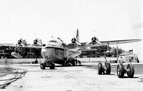
      Anyway, point is that it's been there - Sydney Airport - since a certain Mr Love turned some distant Sydney swamp into an airfield not long into the 20th century. The runways were grassed and switched around a bit over the years, but it wasn't a problem for the locals, really, as it was just a swampy area fit only for pony racing, golf courses and industry (at least to a developer's eyes). When international air travel began to take off it was from Rose Bay, not Mascot. Flying boats were the long-haul heavy-lifters of their day. What happened next however is that Love's Mascot airfield slowly grew and so did the surrounding suburbs. And when the flying boats boomed then declined after the second world war Sydney's major air traffic needed to shift to the land - and thus the chickens came home to roost.

      Traffic of course grew and runways became fixed - and longer. Aircraft now flew in and out over those growing suburbs to the west and the golf courses to the east. Until suddenly 747s arrived with larger payloads and longer runway requirements. Hence the focus shifted to the short north-south runway which was lengthened substantially into the bay. And then a parallel runway to that was built as well. But well before all of that came to pass various plans were put forward for a "second" Sydney Airport. Indeed there were studies galore.

      In the 1970's it was proposed that the Central Coast could well be the right site for a second airport (although in truth there have always been many more airfields in Sydney than just one, indeed Bankstown Aiport has regularly exceeded Sydney in air movement volumes) and a lumpy, foggy and expensive Somersby site was seriously considered, amongst others. But political will was weak and impetus was lost until finally the Badgery's Creek site was selected in western Sydney. Or so we thought. In fact it stalled. And we are left here, decades later, with just the one "main" domestic and international airport at Mascot. Which suits the commercial airport operator just fine, of course, and keeps things simple for airlines and passengers, too. (There's no confusion over which airfield is which, for example, and no expensive transfer to distant termials to change flights.)

      Of course Sydney AP could stay "as is" for decades, anyway, or even grow further into the bay.  But the wheels are still turning on a "second" airport - if slowly - and Badgery's - or is it Wilton? - may one day come to be. But that doesn't stop the odd proposal for a regional airport that could siphon off some Sydney air traffic, just like Newcastle airport does today but moreso. It's not a "second Sydney airport" like the beat-up kings at The Telegraph would have us believe but a serious regional airport that would - if allowed to proceed - attract many northern-dwelling Sydney-siders looking for an easier way to fly within Australia. It would be an economic  boon to the Central Coast and make interstate air travel more attractive to many, getting more cars off the roads. But it will get tarred with the usual brush, of course, and is almost certainly doomed.   

      Council's airport fibs put region in tailspin | thetelegraph.com.au
      Wyong mayor Doug Eaton last month accused the media of a beat-up after The Daily Telegraph reported the council's plans for a second Sydney airport. "The key words here are 'regional airport'," he wrote in his weekly local newspaper column.

      "The Sydney media have built it up to be our grab for Sydney's second airport.

      "But all we ever proposed was a single runway, type 3 regional airport, similar to Coffs Harbour or Port Macquarie."

      Mr Eaton has repeatedly stated it was meant to be a small regional airport despite the proposal featuring a 2600m-long runway, which would make it the second longest runway in NSW behind Sydney's main runway and capable of accommodating international flights.

      Yarramalong resident Laurie Eyes, who lodged the GIPA request, said Mr Eaton and the council had been caught out in a "bare-faced lie".

      Back-peddling yesterday, Mr Eaton said he strongly refuted claims he or the council misled the public in that the proposal started out as a push for a second airport.
      Here is an updated list of Sydney's airports.  

      Monday, December 3, 2012

      Bondi Beach once had a dedicated tramway...

      ...with cuttings and bridges and curves.... and now we have buses and cars. Oh well. And the tramway reservation? Gone. Filled in. Some of it became park, some sold off to developers. Like a lot of Sydney's reserved track, just gone.

      Here are some snaps I took in the mid-70s when the in-filling was taking place...