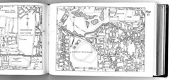
OK, from the left - South Dowling street just stops at Kensington Golf Links. Today it carries on to the airport. To the left of that, Victoria Park Racecourse - gone. Below, Rosebery Park racecourse - gone, replaced by flats - lot's of 'em. To the right of that is a tramway sand quarry (or whatever you call it!). On the next page is Centennial Park at the top, largely intact but now sadly invaded by sports fields and other "single use" recreations like coffee drinking (not that I don't enjoy a coffee) and car parking.
Below that is Randwick Racecourse with its own tram station. Of course pre-war transport was mostly by foot, bike or tram so the dreaded waste and extravagance of low-cost private cars was still ahead of us.
You'll also spot Randwick Tram Workshop in the middle with a few stretches of reserved track so public transport was not only better but quicker. Wait here for trams: Sydney's trams during the last decade of operation
Click through for more personal research and opinion on Sydney history.
Street directory and associated material, scanned for historical research purposes only. Attribution for street directories to HEC Robinson and Gregory's Maps, now UBD. As I say, it's for historical reference only.
My list of Sydney's race tracks and circuits.
or checkout my list of Sydney and surrounding airstrips and airports.
No comments:
Post a Comment